20.3 miles
Distance
823 ft
Climb
-822 ft
Descent
1,082 ft
High Point
928 ft
Altitude min
1,025 ft
Altitude start
1,027 ft
Altitude end
-24.6%
Grade max
38.3%
Grade min
4 miles
Distance climb
4 miles
Distance down
13 miles
Distance flat

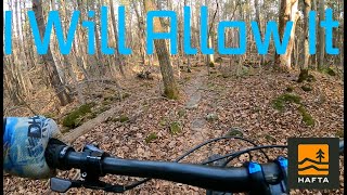
A good tour of what the Agreement Forest/Hilton Falls has to offer. Tough route on a hardtail, Full suspension recommended. Thanks to the trail builders.

Detailed Description
Hardtail Hell is a 20 mile moderately popular expert route located near Milton Ontario. This mountain bike only route can be used one direction and has a hard overall physical rating. This route includes 25 trails. This route climbs 823 ft with a max elevation of 1,082 ft then descends -822 ft.

Trail Issues on Route

  • Significant Issue / Amber: 1 trail (newest: Mar 15, 2026)
  • Minor Issue / Yellow: 1 trail (newest: Sep 19, 2022)
Local Trail Association
Local trail association
Conservation Halton (www.conservationhalton.ca)
Please consider joining or donating to the local riding association to support trail development & maintenance.
Donate to earn trail karma!

Stats

  • Distance
    20 miles
  • Avg time
    3 hr 40 min
  • Altitude min
    928 ft
  • Altitude start
    1,025 ft
  • Altitude end
    1,027 ft
  • Climb
    823 ft
  • Descent
    -822 ft
  • Grade max
    -24.6%
  • Grade min
    38.3%
  • Distance climb
    4 miles
  • Distance down
    4 miles
  • Distance flat
    13 miles

28 Reviews & Comments


We hope you've been enjoying Trailforks!

Create a FREE account to view route comments and much more.

Details

  • Riding area
  • Primary Activity
    Mountain Bike
  • Difficulty rating
    Black Diamond
  • Route Type
    Loop
  • Bike type
    AM, XC, Fat
  • Direction
    One Direction
  • Physical rating
    Hard
  • Ridelogs
    3
no votes yet
close
3D
Trail Conditions
  • Unknown
  • Snow Groomed
  • Snow Packed
  • Snow Covered
  • Snow Cover Partial
  • Freeze/thaw Cycle
  • Icy
  • Prevalent Mud
  • Wet
  • Variable
  • Ideal
  • Dry
  • Very Dry
Trail Flow (Ridden Direction)
Trailforks scans users ridelogs to determine the most popular direction each trail is ridden. A good flowing trail network will have most trails flowing in a single direction according to their intension.
The colour categories are based on what percentage of riders are riding a trail in its intended direction.
  • > 96%
  • > 90%
  • > 80%
  • > 70%
  • > 50%
  • < 50%
  • bi-directional trail
  • no data
Trail Last Ridden
Trailforks scans ridelogs to determine the last time a trail was ridden.
  • < 2 days
  • < 1 week
  • < 2 weeks
  • < 1 month
  • < 6 months
  • > 6 months
Trail Ridden Direction
The intended direction a trail should be ridden.
  • Downhill Only
  • Downhill Primary
  • Both Directions
  • Uphill Primary
  • Uphill Only
  • One Direction
Contribute Details
Colors indicate trail is missing specified detail.
  • Description
  • Photos
  • Description & Photos
  • Videos
Trail Popularity ?
Trailforks scans ridelogs to determine which trails are ridden the most in the last 9 months. Trails are compared with nearby trails in the same city region with a possible 25 colour shades. Think of this as a heatmap, more rides = more kinetic energy = warmer colors.
  • most popular
  • popular
  • less popular
  • not popular
ATV/ORV/OHV Filter
Max Vehicle Width
inches
US Cell Coverage
Legend
cell carrier legend

Radar Time
Activity Recordings
Trailforks uses anonymized public activity data. ?
Activity Recordings
Trailforks uses anonymized public activity data. ?
Personal Heatmap
Activity Types
all / none
Options
2
Date range month
Winter Trails
Warning A routing network for winter maps does not exist. Selecting trails using the winter trails layer has been disabled.
Missing Trails
Most Popular
Least Popular
Trails are colored based on popularity. The more popular a trail is, the more red. Less popular trails trend towards green.
Jump Magnitude Heatmap
Heatmap of where riders jump on trails. Zoom in to see individual jumps, click circles to view jump details.
BC Backroad Status

Service Road Atlas is a free to use, community-driven service for viewing and creating reports on the numerous back-country service roads around B.C. and Alberta.

map legend
Slope Aspect
Direction the slope faces
Flat N NE E SE S SW W NW
Trails Deemphasized
Trails are shown in grey.
disable
Only show trails with no bike usage.
Enable
Suggested Layers
Based on selected activity type

    Save the current map location and zoom level as your default home location whenever this page is loaded.

    Save
    Trail transparency
    • Singletrack
    56
    44
    124
    364
    I Will Allow It
    I Will Allow It
    4:02 | 105 | comments: 0 | favs:
    Oct 31, 2024
    The Den
    The Den
    trail: The Den
    8:01 | 693 | comments: 0 | favs:
    Sep 22, 2021

    Recent Trail Reports Along Route

    statustraildateconditiondescription
    Bat Boxes
    Jun 15, 2026 @ 7:08pm (America/Toronto)
    Jun 15, 2026
    The Den
    Jun 12, 2026 @ 2:17pm (America/Toronto)
    Jun 12, 2026
    we should rock.this up reporter
    I Will Allow It
    Apr 24, 2026 @ 2:04pm (America/Toronto)
    Apr 24, 2026
    Tim Horton's
    Apr 24, 2026 @ 2:04pm (America/Toronto)
    Apr 24, 2026
    Bent Rim 2
    Apr 24, 2026 @ 2:04pm (America/Toronto)
    Apr 24, 2026
    more reports »
    • By skateboardnorthTF Pro & contributors
    • #23094 - 1,613 views

    Hit the Trail

    Open in App

    Get this route on your phone instantly.

    Download Route

    Save to wishlist, Garmin & download.