7.6 miles
Distance
369 ft
Climb
-616 ft
Descent
4,285 ft
High Point
-247 ft
Altitude change
3,787 ft
Altitude min
4,282 ft
Altitude start
4,035 ft
Altitude end
-0.6%
Grade
-23.9%
Grade max
13.7%
Grade min
2 miles
Distance climb
4 miles
Distance down
1 mile
Distance flat

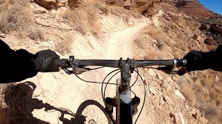
Take deadringer down, all downhill. and then come back on goosebump.

Detailed Description
Hurricane is a 8 mile popular intermediate route located near Hurricane Utah. This mountain bike only route. This route includes 2 trails. This route climbs 369 ft with a max elevation of 4,285 ft then descends -616 ft.
Local Trail Association
Please consider joining or donating to the local riding association to support trail development & maintenance.
Donate to earn trail karma!

Stats

  • Distance
    8 miles
  • Altitude change
    -247 ft
  • Altitude min
    3,787 ft
  • Altitude start
    4,282 ft
  • Altitude end
    4,035 ft
  • Climb
    369 ft
  • Descent
    -616 ft
  • Grade
    -0.6%
  • Grade max
    -23.9%
  • Grade min
    13.7%
  • Distance climb
    2 miles
  • Distance down
    4 miles
  • Distance flat
    1 mile

24 Reviews & Comments


We hope you've been enjoying Trailforks!

Create a FREE account to view route comments and much more.

Trails in Route

Dead Ringer4 miles
Connector171 ft

Details

  • Riding area
  • Primary Activity
    Mountain Bike
  • Difficulty rating
    Blue
no votes yet
close
3D
Trail Conditions
  • Unknown
  • Snow Groomed
  • Snow Packed
  • Snow Covered
  • Snow Cover Partial
  • Freeze/thaw Cycle
  • Icy
  • Prevalent Mud
  • Wet
  • Variable
  • Ideal
  • Dry
  • Very Dry
Trail Flow (Ridden Direction)
Trailforks scans users ridelogs to determine the most popular direction each trail is ridden. A good flowing trail network will have most trails flowing in a single direction according to their intension.
The colour categories are based on what percentage of riders are riding a trail in its intended direction.
  • > 96%
  • > 90%
  • > 80%
  • > 70%
  • > 50%
  • < 50%
  • bi-directional trail
  • no data
Trail Last Ridden
Trailforks scans ridelogs to determine the last time a trail was ridden.
  • < 2 days
  • < 1 week
  • < 2 weeks
  • < 1 month
  • < 6 months
  • > 6 months
Trail Ridden Direction
The intended direction a trail should be ridden.
  • Downhill Only
  • Downhill Primary
  • Both Directions
  • Uphill Primary
  • Uphill Only
  • One Direction
Contribute Details
Colors indicate trail is missing specified detail.
  • Description
  • Photos
  • Description & Photos
  • Videos
Trail Popularity ?
Trailforks scans ridelogs to determine which trails are ridden the most in the last 9 months. Trails are compared with nearby trails in the same city region with a possible 25 colour shades. Think of this as a heatmap, more rides = more kinetic energy = warmer colors.
  • most popular
  • popular
  • less popular
  • not popular
ATV/ORV/OHV Filter
Max Vehicle Width
inches
US Cell Coverage
Legend
cell carrier legend

Radar Time
Activity Recordings
Trailforks uses anonymized public activity data. ?
Activity Recordings
Trailforks uses anonymized public activity data. ?
Personal Heatmap
Activity Types
all / none
Options
2
Date range month
Winter Trails
Warning A routing network for winter maps does not exist. Selecting trails using the winter trails layer has been disabled.
Missing Trails
Most Popular
Least Popular
Trails are colored based on popularity. The more popular a trail is, the more red. Less popular trails trend towards green.
Jump Magnitude Heatmap
Heatmap of where riders jump on trails. Zoom in to see individual jumps, click circles to view jump details.
BC Backroad Status

Service Road Atlas is a free to use, community-driven service for viewing and creating reports on the numerous back-country service roads around B.C. and Alberta.

map legend
Slope Aspect
Direction the slope faces
Flat N NE E SE S SW W NW
Trails Deemphasized
Trails are shown in grey.
disable
Only show trails with no bike usage.
Enable
Suggested Layers
Based on selected activity type

    Save the current map location and zoom level as your default home location whenever this page is loaded.

    Save
    Trail transparency
    • Singletrack
    31
    26
    431
    447

    Recent Trail Reports Along Route

    statustraildateconditiondescription
    Dead Ringer
    Apr 20, 2026 @ 9:38am (America/Phoenix)
    Apr 20, 2026
    Connector
    Mar 13, 2026 @ 2:49pm (America/Denver)
    Mar 13, 2026
    Great shape!
    more reports »
    • By luketielemansTF Pro & contributors
    • #67048 - 44 views

    Hit the Trail

    Open in App

    Get this route on your phone instantly.

    Download Route

    Save to wishlist, Garmin & download.