more stats
4.4 miles
Distance
502 ft
Climb
-23 ft
Descent
00:33:27
Avg time
479 ft
Altitude change
3,786 ft
Altitude min
4,265 ft
Altitude max
3,786 ft
Altitude start
4,265 ft
Altitude end
2.1%
Grade
-4.3%
Grade max
16.5%
Grade min
3 miles
Distance climb
2,211 ft
Distance down
2,858 ft
Distance flat
00:33:27
Avg time

Dead Ringer Details

  • Activities
    • Mountain Bike
    • Gravel Bike
    • Adaptive Bike
    • Winter Fat Bike
    • Hike
    • Trail Running
  • Riding Area
    Hurricane Cliffs
    Hurricane, Utah
  • Difficulty Rating
  • Voted Difficulty
    Blue (3 votes)
  • Local Popularity
    95 in Mountain Biking [+]
    • 65 in Trail Running
    • 95 in Hiking
  • Global Ranking
    #12753 in Mountain Biking [+]
    • #2951 in Trail Running
    • #1307 in Hiking
  • Trail Type
    Singletrack
  • Bike Type
    AM, XC, Fat, Adaptive MTB, Gravel
  • Direction
    Both Directions
  • Climb Difficulty
    Blue
  • Physical Rating
    Moderate
  • Dogs Allowed
    Yes
  • eBike Allowed
  • Year Opened
    2014
  • Land Owner
    Bureau of Land Management

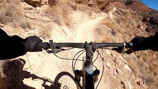
New extension to the Goosebumps trails. This trail was built and designed as a climbing trail to access the top of the JEM trail (Southern most end also the highest point). There is a section of climb that is bench cut leaving little to no room for passing, as this trail is used primarily as a climb, please descend with care and caution.
Overall a great climb.

Adaptive Bike Info
aMTB Blue Rating: Intermediate features and steeper terrain.

Trailer is 24 to 36 inches wide. Mostly on camera, though there are Probably five or six spots that is definitely off camper during the climb. Little to no true exposure, but you don’t want to fall into a wash. No technical sections, it’s a smooth elevator to the top of Jem.

Trail Supporters
  • BLM
    BLM
    Land Manager
Local Trail Association
Traditionally Indigenous Territory

Recent Activity on Trail

Past Week
  • 6 rides
  • 17 miles average
6 Months
  • 170 rides
  • 19 miles avg distance
All
  • 1,319 rides
  • Last: Jun 24, 2026
c1c2c3c4
January
February
March
April
May
June
July
August
September
October
November
December
update trails status or condition

Dead Ringer Trail Reports

statusdatedescription
Apr 20, 2026 @ 9:38am (America/Phoenix)
Apr 20, 2026
Apr 9, 2026 @ 6:26pm (America/Phoenix)
Apr 9, 2026
Mar 13, 2026 @ 2:49pm (America/Denver)
Mar 13, 2026
Great shape!
Feb 1, 2026 @ 11:19am (America/Denver)
Feb 1, 2026
Jan 18, 2026 @ 11:26pm (America/Denver)
Jan 18, 2026
Lots of soft and muddy sections this morning. We tried both directions where Deadringer intersects with Jem and it was pretty bad sticky mud so we...
more »
Status:
on Apr 20, 2026
Very Dry
Avg: 4.02 (56 votes)
Your vote: 0

view (5,310)
close
3D
Trail Conditions
  • Unknown
  • Snow Groomed
  • Snow Packed
  • Snow Covered
  • Snow Cover Partial
  • Freeze/thaw Cycle
  • Icy
  • Prevalent Mud
  • Wet
  • Variable
  • Ideal
  • Dry
  • Very Dry
Trail Flow (Ridden Direction)
Trailforks scans users ridelogs to determine the most popular direction each trail is ridden. A good flowing trail network will have most trails flowing in a single direction according to their intension.
The colour categories are based on what percentage of riders are riding a trail in its intended direction.
  • > 96%
  • > 90%
  • > 80%
  • > 70%
  • > 50%
  • < 50%
  • bi-directional trail
  • no data
Trail Last Ridden
Trailforks scans ridelogs to determine the last time a trail was ridden.
  • < 2 days
  • < 1 week
  • < 2 weeks
  • < 1 month
  • < 6 months
  • > 6 months
Trail Ridden Direction
The intended direction a trail should be ridden.
  • Downhill Only
  • Downhill Primary
  • Both Directions
  • Uphill Primary
  • Uphill Only
  • One Direction
Contribute Details
Colors indicate trail is missing specified detail.
  • Description
  • Photos
  • Description & Photos
  • Videos
Trail Popularity ?
Trailforks scans ridelogs to determine which trails are ridden the most in the last 9 months. Trails are compared with nearby trails in the same city region with a possible 25 colour shades. Think of this as a heatmap, more rides = more kinetic energy = warmer colors.
  • most popular
  • popular
  • less popular
  • not popular
ATV/ORV/OHV Filter
Max Vehicle Width
inches
US Cell Coverage
Legend
cell carrier legend

Radar Time
Activity Recordings
Trailforks uses anonymized public activity data. ?
Activity Recordings
Trailforks uses anonymized public activity data. ?
Personal Heatmap
Activity Types
all / none
Options
2
Date range month
Winter Trails
Warning A routing network for winter maps does not exist. Selecting trails using the winter trails layer has been disabled.
Missing Trails
Most Popular
Least Popular
Trails are colored based on popularity. The more popular a trail is, the more red. Less popular trails trend towards green.
Jump Magnitude Heatmap
Heatmap of where riders jump on trails. Zoom in to see individual jumps, click circles to view jump details.
BC Backroad Status

Service Road Atlas is a free to use, community-driven service for viewing and creating reports on the numerous back-country service roads around B.C. and Alberta.

map legend
Slope Aspect
Direction the slope faces
Flat N NE E SE S SW W NW
Trails Deemphasized
Trails are shown in grey.
disable
Only show trails with no bike usage.
Enable
Suggested Layers
Based on selected activity type

    Save the current map location and zoom level as your default home location whenever this page is loaded.

    Save
        Directions to dead-ringer trailhead (37.176490, -113.239490)

        Photos

        44 more »
        431 |
        Jul 19, 2018 @ 8:11am
        Jul 19, 2018
        447 |
        Jul 12, 2018 @ 5:28pm
        Jul 12, 2018
        31 |
        Apr 12, 2026 @ 4:39pm
        Apr 12, 2026
        26 |
        Apr 12, 2026 @ 2:50pm
        Apr 12, 2026

        Videos

        4 more »
        youtuber Best mountain bike flow trail in Hurricane, UT...
        11:45 | 197 | Apr 1, 2025 , Hurricane
        Twitch’n! Hurricane, Utah MTB | Dead Ringer...
        22:53 | 381 | Jan 7, 2023 , Hurricane
        Dead Ringer on JEM Trail
        1630 | Mar 17, 2017 , Hurricane
        Dead Ringer Upper Section
        2:41 | 249 | Sep 23, 2020 , Hurricane

        Trail Lists

        Routes with this trail

        5.0 17 miles 1,287 ft 22 Loop
        Just a cool loop to discover Hurricane flat
        1.0 22 miles 1,742 ft 8
        Partial and
        8 miles 369 ft 2
        Take deadringer down, all downhill. and then come back on goosebump.

        24 Reviews & Comments


        We hope you've been enjoying Trailforks!

        Create a FREE account to view trail comments and much more.

        • By toddTF Pro Trailforks & contributors
        • #24769 - 10,554 views

        Frequently Asked Questions About Dead Ringer

        Where is Dead Ringer located?
        Dead Ringer is located in Hurricane Cliffs, Hurricane, Utah, United States. It is part of the Hurricane Cliffs trail network. The trailhead is located at coordinates 37.17649, -113.23949.
        How hard is Dead Ringer?
        Dead Ringer is rated as Blue difficulty. The physical rating is Moderate. The average grade is 2.1%. The climb difficulty is rated Blue.
        What is the elevation gain for Dead Ringer?
        Dead Ringer has 502 ft of elevation gain. The trail has 23 ft of elevation descent. The elevation ranges from 3,786 ft to 4,265 ft.
        Is Dead Ringer a point to point trail?
        Dead Ringer is not a point to point trail. The direction is Both Directions. The trail type is singletrack.

        Hit the Trail

        Open in App

        Get this trail on your phone instantly.
        open trail in app

        Download Trail

        Save to wishlist, Garmin & download.
        save the trail

        Find Related Routes

        Find routes and users activities that include this trail.
        find routes for this trail

        You must enter a description before submitting.