18.2 miles
Distance
3,197 ft
Climb
-3,201 ft
Descent
1 mile
High Point
-5 ft
Altitude change
4,914 ft
Altitude min
4,930 ft
Altitude start
4,925 ft
Altitude end
-52.7%
Grade max
52.3%
Grade min
12 miles
Distance climb
6 miles
Distance down
2,198 ft
Distance flat

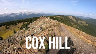
Somewhat civilized, but definitely not an easy loop. This route has fewer hikers on the climb up to the ridge.

Detailed Description
JP Cox Loop is a 18 mile popular expert route located near Jumpingpound Ridge Alberta. This mountain bike only route can be used one direction and has a hard overall physical rating. This route includes 8 trails. This route climbs 3,197 ft with a max elevation of 7,268 ft then descends -3,201 ft.

Trail Issues on Route

  • Minor Issue / Yellow: 1 trail (newest: Oct 10, 2025)

Stats

  • Distance
    18 miles
  • Avg time
    3 hr 27 min
  • Altitude min
    4,914 ft
  • Altitude start
    4,930 ft
  • Altitude end
    4,925 ft
  • Climb
    3,197 ft
  • Descent
    -3,201 ft
  • Grade max
    -52.7%
  • Grade min
    52.3%
  • Distance climb
    12 miles
  • Distance down
    6 miles
  • Distance flat
    2,198 ft

17 Reviews & Comments


We hope you've been enjoying Trailforks!

Create a FREE account to view route comments and much more.

Details

  • Riding area
  • Primary Activity
    Mountain Bike
  • AKA
    Jumping Pound Cox Hill
  • Difficulty rating
    Black Diamond
  • Route Type
    Loop
  • Bike type
    AM, XC
  • Direction
    One Direction
  • Physical rating
    Hard
  • Ridelogs
    35
Avg: 4 (3 votes)
close
3D
Trail Conditions
  • Unknown
  • Snow Groomed
  • Snow Packed
  • Snow Covered
  • Snow Cover Partial
  • Freeze/thaw Cycle
  • Icy
  • Prevalent Mud
  • Wet
  • Variable
  • Ideal
  • Dry
  • Very Dry
Trail Flow (Ridden Direction)
Trailforks scans users ridelogs to determine the most popular direction each trail is ridden. A good flowing trail network will have most trails flowing in a single direction according to their intension.
The colour categories are based on what percentage of riders are riding a trail in its intended direction.
  • > 96%
  • > 90%
  • > 80%
  • > 70%
  • > 50%
  • < 50%
  • bi-directional trail
  • no data
Trail Last Ridden
Trailforks scans ridelogs to determine the last time a trail was ridden.
  • < 2 days
  • < 1 week
  • < 2 weeks
  • < 1 month
  • < 6 months
  • > 6 months
Trail Ridden Direction
The intended direction a trail should be ridden.
  • Downhill Only
  • Downhill Primary
  • Both Directions
  • Uphill Primary
  • Uphill Only
  • One Direction
Contribute Details
Colors indicate trail is missing specified detail.
  • Description
  • Photos
  • Description & Photos
  • Videos
Trail Popularity ?
Trailforks scans ridelogs to determine which trails are ridden the most in the last 9 months. Trails are compared with nearby trails in the same city region with a possible 25 colour shades. Think of this as a heatmap, more rides = more kinetic energy = warmer colors.
  • most popular
  • popular
  • less popular
  • not popular
ATV/ORV/OHV Filter
Max Vehicle Width
inches
US Cell Coverage
Legend
cell carrier legend

Radar Time
Activity Recordings
Trailforks uses anonymized public activity data. ?
Activity Recordings
Trailforks uses anonymized public activity data. ?
Personal Heatmap
Activity Types
all / none
Options
2
Date range month
Winter Trails
Warning A routing network for winter maps does not exist. Selecting trails using the winter trails layer has been disabled.
Missing Trails
Most Popular
Least Popular
Trails are colored based on popularity. The more popular a trail is, the more red. Less popular trails trend towards green.
Jump Magnitude Heatmap
Heatmap of where riders jump on trails. Zoom in to see individual jumps, click circles to view jump details.
BC Backroad Status

Service Road Atlas is a free to use, community-driven service for viewing and creating reports on the numerous back-country service roads around B.C. and Alberta.

map legend
Slope Aspect
Direction the slope faces
Flat N NE E SE S SW W NW
Trails Deemphasized
Trails are shown in grey.
disable
Only show trails with no bike usage.
Enable
Suggested Layers
Based on selected activity type

    Save the current map location and zoom level as your default home location whenever this page is loaded.

    Save
    Trail transparency
    • Singletrack
    • Unpaved
    50
    54
    47
    60
    Cox Hill Elites | Mountain Biking video
    Cox Hill Elites | Mountain Biking video
    3:15 | 125 | comments: 0 | favs:
    Sep 15, 2025
    Cox Hill Trail - The Uphill was brutal,...
    Cox Hill Trail - The Uphill was brutal, Downhill was so rewarding!
    32:59 | 114 | comments: 0 | favs:
    Sep 1, 2025

    Recent Trail Reports Along Route

    statustraildateconditiondescription
    Tom Snow
    Jun 7, 2026 @ 12:05pm (America/Edmonton)
    Jun 7, 2026
    Jumpingpound Summit Trail
    Oct 10, 2025 @ 11:12am (America/Edmonton)
    Oct 10, 2025
    A few minor wet spots at the start of the climb, and 1 or 2 small patches of snow up top that are easily ridden through. No sniper roots or rocks despite the handful of wet/snowy spots, although the trail is over all chunkier than I remember...
    Jumping Pound Trail
    Sep 13, 2025 @ 11:09am (America/Creston)
    Sep 13, 2025
    Cox Hill Trail
    Aug 23, 2025 @ 9:32am
    Aug 23, 2025
    Jumping Pound Ridge Trail
    Sep 19, 2021 @ 11:59am
    Sep 19, 2021
    more reports »
    • By pinkrobe & contributors
    • #3199 - 9,476 views

    Hit the Trail

    Open in App

    Get this route on your phone instantly.

    Download Route

    Save to wishlist, Garmin & download.