11.3 miles
Distance
1,691 ft
Climb
-1,692 ft
Descent
1 mile
High Point
-1 ft
Altitude change
4,827 ft
Altitude min
4,828 ft
Altitude start
4,826 ft
Altitude end
-60.6%
Grade max
29.8%
Grade min
6 miles
Distance climb
4 miles
Distance down
4,639 ft
Distance flat

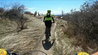
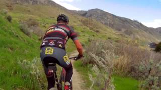
This ride starts and ends the Wade Springs Trailhead parking lot. The real singletrack starts and ends at Valley Vista. The spin up is a bit of a grind but not rocky or loose. Only as you approach the very top of thunderdome does the trail get a bit more difficult to navigate, but mostly due to some steep pitches. The rocks and small roots are embedded.

Once you reach the top of Thunderdome, you will have a 3-sided view of the valley below. The drop down is a loose and rocky riot. Some sections are very straight lines with big speed. There are a few places to check your speed where there are some abrupt turns and what a very big whoop-di-do that you do not want to huck to flat on. Do the descent once with reasonable speed before attempting it full gas.

Detailed Description
Master Blaster is a 11 mile popular intermediate route located near Pleasant Grove Utah. This mountain bike only route can be used one direction and has a hard overall physical rating. This route includes 15 trails. This route climbs 1,691 ft with a max elevation of 6,289 ft then descends -1,692 ft.
Local Trail Association
Utah Rocky Mountain Bikers
Please consider joining or donating to the local riding association to support trail development & maintenance.
Donate to earn trail karma!

Stats

  • Distance
    11 miles
  • Avg time
    1 hr 49 min
  • Altitude min
    4,827 ft
  • Altitude start
    4,828 ft
  • Altitude end
    4,826 ft
  • Climb
    1,691 ft
  • Descent
    -1,692 ft
  • Grade max
    -60.6%
  • Grade min
    29.8%
  • Distance climb
    6 miles
  • Distance down
    4 miles
  • Distance flat
    4,639 ft

47 Reviews & Comments


We hope you've been enjoying Trailforks!

Create a FREE account to view route comments and much more.

Details

  • Riding area
  • Primary Activity
    Mountain Bike
  • Difficulty rating
    Blue
  • Route Type
    Loop
  • Direction
    One Direction
  • Physical rating
    Hard
  • Ridelogs
    8
Avg: 5 (1 votes)
close
3D
Trail Conditions
  • Unknown
  • Snow Groomed
  • Snow Packed
  • Snow Covered
  • Snow Cover Partial
  • Freeze/thaw Cycle
  • Icy
  • Prevalent Mud
  • Wet
  • Variable
  • Ideal
  • Dry
  • Very Dry
Trail Flow (Ridden Direction)
Trailforks scans users ridelogs to determine the most popular direction each trail is ridden. A good flowing trail network will have most trails flowing in a single direction according to their intension.
The colour categories are based on what percentage of riders are riding a trail in its intended direction.
  • > 96%
  • > 90%
  • > 80%
  • > 70%
  • > 50%
  • < 50%
  • bi-directional trail
  • no data
Trail Last Ridden
Trailforks scans ridelogs to determine the last time a trail was ridden.
  • < 2 days
  • < 1 week
  • < 2 weeks
  • < 1 month
  • < 6 months
  • > 6 months
Trail Ridden Direction
The intended direction a trail should be ridden.
  • Downhill Only
  • Downhill Primary
  • Both Directions
  • Uphill Primary
  • Uphill Only
  • One Direction
Contribute Details
Colors indicate trail is missing specified detail.
  • Description
  • Photos
  • Description & Photos
  • Videos
Trail Popularity ?
Trailforks scans ridelogs to determine which trails are ridden the most in the last 9 months. Trails are compared with nearby trails in the same city region with a possible 25 colour shades. Think of this as a heatmap, more rides = more kinetic energy = warmer colors.
  • most popular
  • popular
  • less popular
  • not popular
ATV/ORV/OHV Filter
Max Vehicle Width
inches
US Cell Coverage
Legend
cell carrier legend

Radar Time
Activity Recordings
Trailforks uses anonymized public activity data. ?
Activity Recordings
Trailforks uses anonymized public activity data. ?
Personal Heatmap
Activity Types
all / none
Options
2
Date range month
Winter Trails
Warning A routing network for winter maps does not exist. Selecting trails using the winter trails layer has been disabled.
Missing Trails
Most Popular
Least Popular
Trails are colored based on popularity. The more popular a trail is, the more red. Less popular trails trend towards green.
Jump Magnitude Heatmap
Heatmap of where riders jump on trails. Zoom in to see individual jumps, click circles to view jump details.
BC Backroad Status

Service Road Atlas is a free to use, community-driven service for viewing and creating reports on the numerous back-country service roads around B.C. and Alberta.

map legend
Slope Aspect
Direction the slope faces
Flat N NE E SE S SW W NW
Trails Deemphasized
Trails are shown in grey.
disable
Only show trails with no bike usage.
Enable
Suggested Layers
Based on selected activity type

    Save the current map location and zoom level as your default home location whenever this page is loaded.

    Save
    Trail transparency
    170
    216
    78
    251
    Valley Vista MTB 4-4-2020
    Valley Vista MTB 4-4-2020
    12:27 | 630 | comments: 0 | favs:
    May 22, 2020
    Valley Vista Trail System
    Valley Vista Trail System
    trail: Gambel
    1159 | comments: 0 | favs:
    Oct 10, 2017

    Recent Trail Reports Along Route

    statustraildateconditiondescription
    Grove Creek Upper
    May 27, 2026 @ 2:13pm (Pacific/Midway)
    May 27, 2026
    Dry as ever
    Pg Upper Conn
    May 27, 2026 @ 2:13pm (Pacific/Midway)
    May 27, 2026
    Dry as ever
    Sneaky
    May 27, 2026 @ 2:13pm (Pacific/Midway)
    May 27, 2026
    Dry as ever
    Valley Vista
    May 27, 2026 @ 12:58pm (America/Boise)
    May 27, 2026
    Cowley's Curse (S)
    May 22, 2026 @ 8:57am (America/Denver)
    May 22, 2026
    more reports »
    • By toddTF Pro Trailforks & contributors
    • #6967 - 3,468 views

    Hit the Trail

    Open in App

    Get this route on your phone instantly.

    Download Route

    Save to wishlist, Garmin & download.