3.8 miles
Distance
234 ft
Climb
-1,818 ft
Descent
2,304 ft
High Point
-1,585 ft
Altitude change
638 ft
Altitude min
2,298 ft
Altitude start
712 ft
Altitude end
-8%
Grade
-61.8%
Grade max
23.1%
Grade min
3,917 ft
Distance climb
3 miles
Distance down
1,355 ft
Distance flat

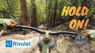
Starting at the springs, this sheds almost 500m of elevation in just over 3km of single track.

Detailed Description
Mega Hoot is a 4 mile popular expert route located near Hobart. This mountain bike only route can be used one direction and has a hard overall physical rating. This route includes 5 trails. This route climbs 234 ft with a max elevation of 2,304 ft then descends -1,818 ft.

Trail Issues on Route

  • Minor Issue / Yellow: 1 trail (newest: Dec 28, 2025)
Local Trail Association
Local trail association
Hobart Dirt Devils (www.dirtdevilsmtb.com)
Please consider joining or donating to the local riding association to support trail development & maintenance.
Donate to earn trail karma!

Stats

  • Distance
    4 miles
  • Avg time
    47 min 17 sec
  • Altitude change
    -1,585 ft
  • Altitude min
    638 ft
  • Altitude start
    2,298 ft
  • Altitude end
    712 ft
  • Climb
    234 ft
  • Descent
    -1,818 ft
  • Grade
    -8%
  • Grade max
    -61.8%
  • Grade min
    23.1%
  • Distance climb
    3,917 ft
  • Distance down
    3 miles
  • Distance flat
    1,355 ft

10 Reviews & Comments


We hope you've been enjoying Trailforks!

Create a FREE account to view route comments and much more.

Trails in Route

Radfords Track4,629 ft
Bracken Lane Fire Trail768 ft
Drops1,791 ft
Rivulet3,970 ft
Cascadia3,993 ft

Details

  • Riding area
  • Primary Activity
    Mountain Bike
  • Difficulty rating
    Black Diamond
  • Route Type
    Shuttled
  • Bike type
    DH, AM
  • Direction
    One Direction
  • Physical rating
    Hard
Avg: 4.5 (2 votes)
close
3D
Trail Conditions
  • Unknown
  • Snow Groomed
  • Snow Packed
  • Snow Covered
  • Snow Cover Partial
  • Freeze/thaw Cycle
  • Icy
  • Prevalent Mud
  • Wet
  • Variable
  • Ideal
  • Dry
  • Very Dry
Trail Flow (Ridden Direction)
Trailforks scans users ridelogs to determine the most popular direction each trail is ridden. A good flowing trail network will have most trails flowing in a single direction according to their intension.
The colour categories are based on what percentage of riders are riding a trail in its intended direction.
  • > 96%
  • > 90%
  • > 80%
  • > 70%
  • > 50%
  • < 50%
  • bi-directional trail
  • no data
Trail Last Ridden
Trailforks scans ridelogs to determine the last time a trail was ridden.
  • < 2 days
  • < 1 week
  • < 2 weeks
  • < 1 month
  • < 6 months
  • > 6 months
Trail Ridden Direction
The intended direction a trail should be ridden.
  • Downhill Only
  • Downhill Primary
  • Both Directions
  • Uphill Primary
  • Uphill Only
  • One Direction
Contribute Details
Colors indicate trail is missing specified detail.
  • Description
  • Photos
  • Description & Photos
  • Videos
Trail Popularity ?
Trailforks scans ridelogs to determine which trails are ridden the most in the last 9 months. Trails are compared with nearby trails in the same city region with a possible 25 colour shades. Think of this as a heatmap, more rides = more kinetic energy = warmer colors.
  • most popular
  • popular
  • less popular
  • not popular
ATV/ORV/OHV Filter
Max Vehicle Width
inches
US Cell Coverage
Legend
cell carrier legend

Radar Time
Activity Recordings
Trailforks uses anonymized public activity data. ?
Activity Recordings
Trailforks uses anonymized public activity data. ?
Personal Heatmap
Activity Types
all / none
Options
2
Date range month
Winter Trails
Warning A routing network for winter maps does not exist. Selecting trails using the winter trails layer has been disabled.
Missing Trails
Most Popular
Least Popular
Trails are colored based on popularity. The more popular a trail is, the more red. Less popular trails trend towards green.
Jump Magnitude Heatmap
Heatmap of where riders jump on trails. Zoom in to see individual jumps, click circles to view jump details.
BC Backroad Status

Service Road Atlas is a free to use, community-driven service for viewing and creating reports on the numerous back-country service roads around B.C. and Alberta.

map legend
Slope Aspect
Direction the slope faces
Flat N NE E SE S SW W NW
Trails Deemphasized
Trails are shown in grey.
disable
Only show trails with no bike usage.
Enable
Suggested Layers
Based on selected activity type

    Save the current map location and zoom level as your default home location whenever this page is loaded.

    Save
    Trail transparency
    • Singletrack
    • Unpaved
    97
    96
    153
    249
    How Hard Can You Push This Blue Trail?
    How Hard Can You Push This Blue Trail?
    trail: Rivulet
    3:19 | 10 | comments: 0 | favs:
    Jun 14, 2026
    Mt Wellington MTB - Sexual Soil | Red Wine |...
    Mt Wellington MTB - Sexual Soil | Red Wine | Drops | Upper Luge Trails
    trail: Drops
    16:02 | 235 | comments: 0 | favs:
    Jan 29, 2025

    Recent Trail Reports Along Route

    statustraildateconditiondescription
    Drops
    Dec 30, 2025 @ 12:05pm (Australia/Hobart)
    Dec 29, 2025
    Rivulet
    Dec 28, 2025 @ 8:34pm (Australia/Hobart)
    Dec 28, 2025
    Tee down across trail
    Cascadia
    Apr 4, 2022 @ 12:12am
    Apr 4, 2022
    Radfords Track
    Nov 3, 2021 @ 1:12pm
    Nov 3, 2021
    A moderate, challenging trail, if you’re walking to see the Disappearing Tarn you’ll be challenged with 2km of hard rock to trek over, 4km from Springs car park to the Tarn and I found the second half the toughest but still a lot of fun : )
    Radfords Track
    Feb 7, 2020 @ 3:21pm
    Feb 7, 2020
    more reports »
    • By SchrodingersGatTF Pro MRTG & contributors
    • #3184 - 2,316 views

    Hit the Trail

    Open in App

    Get this route on your phone instantly.

    Download Route

    Save to wishlist, Garmin & download.