19.8 miles
Distance
2,107 ft
Climb
-2,105 ft
Descent
2 miles
High Point
1 ft
Altitude change
6,939 ft
Altitude min
7,155 ft
Altitude start
7,156 ft
Altitude end
-32.6%
Grade max
26.3%
Grade min
9 miles
Distance climb
9 miles
Distance down
2 miles
Distance flat

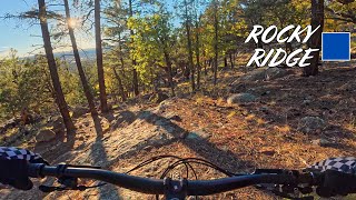
A classic XC / Trail ride in Flagstaff. Nothing too challenging but lots of fun and many great view. The milage can be deceiving; expect the ride to take a bit longer than you might think. The trail network on the south side of Elden is very convoluted and can be hard to navigate if you are unfamiliar so be prepared.

Detailed Description
Mount Elden Loop is a 20 mile moderately popular intermediate route located near Flagstaff Arizona. This mountain bike only route can be used both directions and has a moderate overall physical rating. This route includes 17 trails. This route climbs 2,107 ft with a max elevation of 8,076 ft then descends -2,105 ft.

Trail Issues on Route

  • Minor Issue / Yellow: 1 trail (newest: Apr 11, 2026)
Local Trail Association
Local trail association
Flagstaff Biking Organization (flagstaffbiking.org)
Please consider joining or donating to the local riding association to support trail development & maintenance.
Donate to earn trail karma!

Stats

  • Distance
    20 miles
  • Avg time
    2 hr 18 min
  • Altitude min
    6,939 ft
  • Altitude start
    7,155 ft
  • Altitude end
    7,156 ft
  • Climb
    2,107 ft
  • Descent
    -2,105 ft
  • Grade max
    -32.6%
  • Grade min
    26.3%
  • Distance climb
    9 miles
  • Distance down
    9 miles
  • Distance flat
    2 miles

62 Reviews & Comments


We hope you've been enjoying Trailforks!

Create a FREE account to view route comments and much more.

Details

  • Riding area
  • Primary Activity
    Mountain Bike
  • Difficulty rating
    Blue
  • Route Type
    Loop
  • Bike type
    AM, XC
  • Direction
    Both Directions
  • Physical rating
    Moderate
  • Ridelogs
    19
no votes yet
close
3D
Trail Conditions
  • Unknown
  • Snow Groomed
  • Snow Packed
  • Snow Covered
  • Snow Cover Partial
  • Freeze/thaw Cycle
  • Icy
  • Prevalent Mud
  • Wet
  • Variable
  • Ideal
  • Dry
  • Very Dry
Trail Flow (Ridden Direction)
Trailforks scans users ridelogs to determine the most popular direction each trail is ridden. A good flowing trail network will have most trails flowing in a single direction according to their intension.
The colour categories are based on what percentage of riders are riding a trail in its intended direction.
  • > 96%
  • > 90%
  • > 80%
  • > 70%
  • > 50%
  • < 50%
  • bi-directional trail
  • no data
Trail Last Ridden
Trailforks scans ridelogs to determine the last time a trail was ridden.
  • < 2 days
  • < 1 week
  • < 2 weeks
  • < 1 month
  • < 6 months
  • > 6 months
Trail Ridden Direction
The intended direction a trail should be ridden.
  • Downhill Only
  • Downhill Primary
  • Both Directions
  • Uphill Primary
  • Uphill Only
  • One Direction
Contribute Details
Colors indicate trail is missing specified detail.
  • Description
  • Photos
  • Description & Photos
  • Videos
Trail Popularity ?
Trailforks scans ridelogs to determine which trails are ridden the most in the last 9 months. Trails are compared with nearby trails in the same city region with a possible 25 colour shades. Think of this as a heatmap, more rides = more kinetic energy = warmer colors.
  • most popular
  • popular
  • less popular
  • not popular
ATV/ORV/OHV Filter
Max Vehicle Width
inches
US Cell Coverage
Legend
cell carrier legend

Radar Time
Activity Recordings
Trailforks uses anonymized public activity data. ?
Activity Recordings
Trailforks uses anonymized public activity data. ?
Personal Heatmap
Activity Types
all / none
Options
2
Date range month
Winter Trails
Warning A routing network for winter maps does not exist. Selecting trails using the winter trails layer has been disabled.
Missing Trails
Most Popular
Least Popular
Trails are colored based on popularity. The more popular a trail is, the more red. Less popular trails trend towards green.
Jump Magnitude Heatmap
Heatmap of where riders jump on trails. Zoom in to see individual jumps, click circles to view jump details.
BC Backroad Status

Service Road Atlas is a free to use, community-driven service for viewing and creating reports on the numerous back-country service roads around B.C. and Alberta.

map legend
Slope Aspect
Direction the slope faces
Flat N NE E SE S SW W NW
Trails Deemphasized
Trails are shown in grey.
disable
Only show trails with no bike usage.
Enable
Suggested Layers
Based on selected activity type

    Save the current map location and zoom level as your default home location whenever this page is loaded.

    Save
    Trail transparency
    • Singletrack
    • Unpaved
    20
    21
    21
    19
    youtuber A Hidden Gem | Flagstaff, Arizona.
    A Hidden Gem | Flagstaff, Arizona.
    10:07 | 1025 | comments: 0 | favs:
    Nov 27, 2019
    Flagstaff Trail Guide: Rocky Ridge
    Flagstaff Trail Guide: Rocky Ridge
    21:16 | 38 | comments: 0 | favs:
    Nov 13, 2025

    Recent Trail Reports Along Route

    statustraildateconditiondescription
    Schultz Creek
    Jun 3, 2026 @ 12:39pm (America/Phoenix)
    Jun 3, 2026
    Christmas Tree
    May 2, 2026 @ 7:56pm (America/Phoenix)
    May 2, 2026
    AZT - Little Elden Trail
    May 2, 2026 @ 5:10pm (America/Phoenix)
    May 2, 2026
    Sunset (Lower)
    Apr 11, 2026 @ 3:37pm (America/Phoenix)
    Apr 11, 2026
    Tree down 1.5km from Sunset Trailhead
    Rocky Ridge Trail
    Sep 25, 2025 @ 10:38am (America/Phoenix)
    Sep 25, 2025
    Conditions were good. Dry, not too dusty. I suspect that the afternoon's extensive hailstorm helped dampen it all down.
    more reports »
    • By scottay & contributors
    • #5132 - 5,291 views

    Hit the Trail

    Open in App

    Get this route on your phone instantly.

    Download Route

    Save to wishlist, Garmin & download.