8.3 miles
Distance
1,183 ft
Climb
-2,272 ft
Descent
1 mile
High Point
-1,089 ft
Altitude change
6,275 ft
Altitude min
7,402 ft
Altitude start
6,312 ft
Altitude end
-2.5%
Grade
-59.1%
Grade max
50.4%
Grade min
3 miles
Distance climb
5 miles
Distance down
4,295 ft
Distance flat

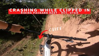
Ride up the road from the Packard trailhead, then take the connector to the Mapleton Ridge trail, and come down Packard trail.

Detailed Description
Packard Loop is a 8 mile moderately popular expert route located near Provo Utah. This mountain bike only route can be used one direction and has a moderate overall physical rating. This route includes 5 trails. This route climbs 1,183 ft with a max elevation of 7,614 ft then descends -2,272 ft.

Trail Issues on Route

  • Minor Issue / Yellow: 3 trails (newest: Jul 2, 2024)
Local Trail Association
Provo Bicycle Committee (www.facebook.com)
Please consider joining or donating to the local riding association to support trail development & maintenance.
Donate to earn trail karma!

Stats

  • Distance
    8 miles
  • Avg time
    1 hr 37 min
  • Altitude min
    6,275 ft
  • Altitude start
    7,402 ft
  • Altitude end
    6,312 ft
  • Climb
    1,183 ft
  • Descent
    -2,272 ft
  • Grade
    -2.5%
  • Grade max
    -59.1%
  • Grade min
    50.4%
  • Distance climb
    3 miles
  • Distance down
    5 miles
  • Distance flat
    4,295 ft

16 Reviews & Comments


We hope you've been enjoying Trailforks!

Create a FREE account to view route comments and much more.

Details

  • Riding area
  • Primary Activity
    Mountain Bike
  • Difficulty rating
    Black Diamond
  • Route Type
    Loop
  • Bike type
    AM, XC
  • Direction
    One Direction
  • Physical rating
    Moderate
  • Ridelogs
    3
no votes yet
close
3D
Trail Conditions
  • Unknown
  • Snow Groomed
  • Snow Packed
  • Snow Covered
  • Snow Cover Partial
  • Freeze/thaw Cycle
  • Icy
  • Prevalent Mud
  • Wet
  • Variable
  • Ideal
  • Dry
  • Very Dry
Trail Flow (Ridden Direction)
Trailforks scans users ridelogs to determine the most popular direction each trail is ridden. A good flowing trail network will have most trails flowing in a single direction according to their intension.
The colour categories are based on what percentage of riders are riding a trail in its intended direction.
  • > 96%
  • > 90%
  • > 80%
  • > 70%
  • > 50%
  • < 50%
  • bi-directional trail
  • no data
Trail Last Ridden
Trailforks scans ridelogs to determine the last time a trail was ridden.
  • < 2 days
  • < 1 week
  • < 2 weeks
  • < 1 month
  • < 6 months
  • > 6 months
Trail Ridden Direction
The intended direction a trail should be ridden.
  • Downhill Only
  • Downhill Primary
  • Both Directions
  • Uphill Primary
  • Uphill Only
  • One Direction
Contribute Details
Colors indicate trail is missing specified detail.
  • Description
  • Photos
  • Description & Photos
  • Videos
Trail Popularity ?
Trailforks scans ridelogs to determine which trails are ridden the most in the last 9 months. Trails are compared with nearby trails in the same city region with a possible 25 colour shades. Think of this as a heatmap, more rides = more kinetic energy = warmer colors.
  • most popular
  • popular
  • less popular
  • not popular
ATV/ORV/OHV Filter
Max Vehicle Width
inches
US Cell Coverage
Legend
cell carrier legend

Radar Time
Activity Recordings
Trailforks uses anonymized public activity data. ?
Activity Recordings
Trailforks uses anonymized public activity data. ?
Personal Heatmap
Activity Types
all / none
Options
2
Date range month
Winter Trails
Warning A routing network for winter maps does not exist. Selecting trails using the winter trails layer has been disabled.
Missing Trails
Most Popular
Least Popular
Trails are colored based on popularity. The more popular a trail is, the more red. Less popular trails trend towards green.
Jump Magnitude Heatmap
Heatmap of where riders jump on trails. Zoom in to see individual jumps, click circles to view jump details.
BC Backroad Status

Service Road Atlas is a free to use, community-driven service for viewing and creating reports on the numerous back-country service roads around B.C. and Alberta.

map legend
Slope Aspect
Direction the slope faces
Flat N NE E SE S SW W NW
Trails Deemphasized
Trails are shown in grey.
disable
Only show trails with no bike usage.
Enable
Suggested Layers
Based on selected activity type

    Save the current map location and zoom level as your default home location whenever this page is loaded.

    Save
    Trail transparency
    • Singletrack
    22
    40
    42
    44
    Riding The Packard East Trail
    Riding The Packard East Trail
    8:03 | 358 | comments: 0 | favs:
    Sep 3, 2020
    youtuber The Perfect Trail For A Plus Bike | 29 Plus...
    The Perfect Trail For A Plus Bike | 29 Plus Fat MTB
    8:03 | 366 | comments: 0 | favs:
    Sep 3, 2020

    Recent Trail Reports Along Route

    statustraildateconditiondescription
    Packard Cutoff
    Jul 7, 2024 @ 8:16pm
    Jul 7, 2024
    brush cleared on whole trail.
    Packard East
    Jul 2, 2024 @ 3:36pm
    Jul 2, 2024
    Some water problems that could use attention.
    Packard Canyon Trail
    Nov 14, 2023 @ 2:50pm
    Nov 14, 2023
    Packard Canyon Trail
    Apr 23, 2022 @ 11:26am
    Apr 23, 2022
    Still some snow at the top, and one very large tree that needs to be cleared.
    Mapleton-Sawmill Hollow Trail
    Aug 29, 2020 @ 7:36pm
    Aug 29, 2020
    This was, by FAR, the dryest, moon dustiest trail I have ever ridden in my entire life.
    more reports »
    • By jed-campbellTF Pro & contributors
    • #2000 - 1,539 views

    Hit the Trail

    Open in App

    Get this route on your phone instantly.

    Download Route

    Save to wishlist, Garmin & download.