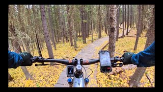
Ridgeback was built and is maintained by the Calgary Mountain Bike Alliance. It's a mix of machine-built and hand-built construction, designed to provide an alternative to the perpetual wetness of the Tom Snow trail.
Ridgeback has a bit of everything - smooth dirt, roots, rocks, berms, boardwalks and views - providing a significant challenge for beginners and a fun rip for more advanced riders.
Ridgeback and Tom Snow come together at three points, dividing Ridgeback into four main sections, all of which are good in either direction. The parts of Tom Snow that Ridgeback bypasses are almost always wet & muddy, especially the section that parallels R3.
Trail Issues on Route
- Minor Issue / Yellow: 4 trails (newest: Jun 13, 2026)
Route Supporters

Calgary Mountain Bike Alliance
since 2009Maintainer
Local Trail Association
Calgary Mountain Bike Alliance (www.cmbalink.com)Stats
-
Distance6 miles
-
Altitude change665 ft
-
Altitude min4,687 ft
-
Altitude start4,737 ft
-
Altitude end5,404 ft
-
Climb1,379 ft
-
Descent-714 ft
-
Grade2.2%
-
Grade max-46.6%
-
Grade min49.9%
-
Distance climb3 miles
-
Distance down2 miles
-
Distance flat3,294 ft
15 Reviews & Comments
We hope you've been enjoying Trailforks!
Create a FREE account to view route comments and much more.
Trails in Route
| 2,516 ft | |||||
| 1 mile | |||||
| 2 miles | |||||
| 4,918 ft |
Details
-
Riding area
-
Primary ActivityMountain Bike
-
Other Activities
- E-Bike
- Winter Fat Bike
- Hike
- Trail Running
- Snowshoe
-
Difficulty ratingBlue
-
Route TypePoint to Point
-
eBike Allowed
-
Bike typeAM, XC
-
DirectionBoth Directions
-
Physical ratingModerate
Directions
- Walk north on Ridgeback 1.
- Continue for 800 meters.
- Keep left to take Ridgeback 2.
- Continue for 2.5 kilometers.
- Turn left onto Tom Snow.
- Continue for 20 meters.
- Keep left to stay on Tom Snow.
- Continue for less than 10 meters.
- Keep straight to stay on Tom Snow.
- Continue for 10 meters.
- Keep left to stay on Tom Snow.
- Continue for 30 meters.
- Keep straight to stay on Tom Snow.
- Continue for 40 meters.
- Keep left to stay on Tom Snow.
- Continue for 30 meters.
- Keep straight to stay on Tom Snow.
- Continue for 40 meters.
- Keep straight to stay on Tom Snow.
- Continue for 20 meters.
- Keep straight to stay on Tom Snow.
- Continue for 10 meters.
- Keep left to stay on Tom Snow.
- Continue for 10 meters.
- Keep right to stay on Tom Snow.
- Continue for 50 meters.
- Turn right to stay on Tom Snow.
- Continue for 10 meters.
- Turn right to stay on Tom Snow.
- Continue for 10 meters.
- Keep straight to stay on Tom Snow.
- Continue for 20 meters.
- Keep left to stay on Tom Snow.
- Continue for 30 meters.
- Bear right onto Ridgeback 3.
- Continue for 3 kilometers.
- Turn left to stay on Ridgeback 3.
- Continue for 1 kilometer.
- Walk south on Ridgeback 4.
- Continue for 1.5 kilometers.
- Unknown
- Snow Groomed
- Snow Packed
- Snow Covered
- Snow Cover Partial
- Freeze/thaw Cycle
- Icy
- Prevalent Mud
- Wet
- Variable
- Ideal
- Dry
- Very Dry
The colour categories are based on what percentage of riders are riding a trail in its intended direction.
- > 96%
- > 90%
- > 80%
- > 70%
- > 50%
- < 50%
- bi-directional trail
- no data
- < 2 days
- < 1 week
- < 2 weeks
- < 1 month
- < 6 months
- > 6 months
- Downhill Only
- Downhill Primary
- Both Directions
- Uphill Primary
- Uphill Only
- One Direction
- Description
- Photos
- Description & Photos
- Videos
- most popular
- popular
- less popular
- not popular
Service Road Atlas is a free to use, community-driven service for viewing and creating reports on the numerous back-country service roads around B.C. and Alberta.
Save the current map location and zoom level as your default home location whenever this page is loaded.
Save- Singletrack
Photos
Videos