13.6 miles
Distance
2,283 ft
Climb
-2,265 ft
Descent
2 miles
High Point
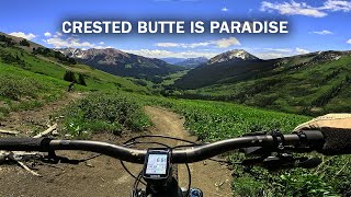
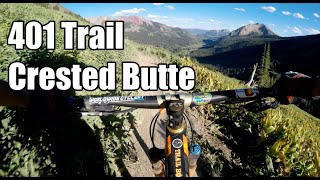
Trail Riders 401 trail is Crested Butte's most famous trail for good reason. Lots of intermediate mountain bikers can be found spinning their way up to behold shoulder high flowers, fast single track, and heavenly views of Mount Crested Butte. Take your time, drink lots of water, and bring some sort of camera. It gets an intermediate plus rating due to the steep, but nontechnical climbing involved on 401, especially at the beginning.
Detailed Description
Trail 401 Loop is a 21882 popular intermediate route located near Crested Butte Colorado. This mountain bike only route. This route includes 1 trails. This route climbs 695.9 with a max elevation of 3459.3 then descends -690.4.
Local Trail Association
Crested Butte Mountain Bike Association (crestedbuttemountainbike.com)Please consider joining or donating to the local riding association to support trail development & maintenance.
donate to earn trail karma!
Trails in Route
8 miles |
Details
More Stats for Trail 401 Loop mountain bike route
-
Altitude change18 ft
-
Altitude min9,583 ft
-
Altitude start9,583 ft
-
Altitude end9,603 ft
-
Grade max-35.9%
-
Grade min50.5%
-
Distance climb7 miles
-
Distance down6 miles
-
Distance flat1 mile
close
Trail Conditions
- Unknown
- Snow Groomed
- Snow Packed
- Snow Covered
- Snow Cover Inadequate
- Freeze/thaw Cycle
- Icy
- Prevalent Mud
- Wet
- Variable
- Ideal
- Dry
- Very Dry
Trail Flow (Ridden Direction)
Trailforks scans users ridelogs to determine the most popular direction each trail is ridden. A good flowing trail network will have most trails flowing in a single direction according to their intension.
The colour categories are based on what percentage of riders are riding a trail in its intended direction.
- > 96%
- > 90%
- > 80%
- > 70%
- > 50%
- < 50%
- bi-directional trail
- no data
Trail Last Ridden
Trailforks scans ridelogs to determine the last time a trail was ridden.
- < 2 days
- < 1 week
- < 2 weeks
- < 1 month
- < 6 months
- > 6 months
Trail Ridden Direction
The intended direction a trail should be ridden.
- Downhill Only
- Downhill Primary
- Both Directions
- Uphill Primary
- Uphill Only
- One Direction
Contribute Details
Colors indicate trail is missing specified detail.
- Description
- Photos
- Description & Photos
- Videos
Trail Popularity ?
Trailforks scans ridelogs to determine which trails are ridden the most in the last 9 months.
Trails are compared with nearby trails in the same city region with a possible 25 colour shades.
Think of this as a heatmap, more rides = more kinetic energy = warmer colors.
- most popular
- popular
- less popular
- not popular
ATV/ORV/OHV Filter
Max Vehicle Width
inches
Radar Time
x
Activity Recordings
Trailforks users anonymized public ridelogs from the past 6 months.
- mountain biking recent
- mountain biking (>6 month)
- hiking (1 year)
- moto (1 year)
Activity Recordings
Trailforks users anonymized public skilogs from the past 12 months.
- Downhill Ski
- Backcountry Ski
- Nordic Ski
Jump Magnitude Heatmap
Heatmap of where riders jump on trails. Zoom in to see individual jumps, click circles to view jump details.
Trails Deemphasized
Trails are shown in grey.
Only show trails with NO bikes.
Trail transparency
Photos
Videos

#MTB2K21 Day 4 - Snodgrass Paradise 401
trail: Trail 401
4:07 | 36 | comments: 0 | favs:
Dec 9, 2021
Recent Trail Reports Along Route
more reports »
- By CBMtnBike
CBMBA & contributors
- #33317 - 248 views
- login to download gpx or kml files.