2.8 miles
Distance
197 ft
Climb
-199 ft
Descent
4,886 ft
High Point
4,715 ft
Altitude min
4,725 ft
Altitude start
4,724 ft
Altitude end
-41.2%
Grade max
17.7%
Grade min
1 mile
Distance climb
3,881 ft
Distance down
5,187 ft
Distance flat

Parking at 2750 N & Mountain Road Trailhead

Warmup on bike traveling south on Mountain Road to 2450 North, turn east to enter Canal Road

Enter Canal Road and start/end is just South of gate on Canal Road (Start & End of Lollipop Loop)

Travel South on Canal Road to the Pipeline BST Connector

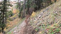
Complete Pipeline BST Connector and enter Coldwater Canyon (BST) traveling North to One Horse Shortcut

Travel West on One Horse Shortcut back to Canal Road

Travel North on Canal Road back to gate near 2450 North

Detailed Description
Weber High Loop is a 3 mile popular easy route located near North Ogden Utah. This mountain bike only route can be used one direction and has a easy overall physical rating. This route includes 3 trails. This route climbs 197 ft with a max elevation of 4,886 ft then descends -199 ft.
Local Trail Association
Please consider joining or donating to the local riding association to support trail development & maintenance.
Donate to earn trail karma!

Stats

  • Distance
    3 miles
  • Altitude min
    4,715 ft
  • Altitude start
    4,725 ft
  • Altitude end
    4,724 ft
  • Climb
    197 ft
  • Descent
    -199 ft
  • Grade max
    -41.2%
  • Grade min
    17.7%
  • Distance climb
    1 mile
  • Distance down
    3,881 ft
  • Distance flat
    5,187 ft

1 Review & Comments


We hope you've been enjoying Trailforks!

Create a FREE account to view route comments and much more.

Details

  • Riding area
  • Primary Activity
    Mountain Bike
  • Difficulty rating
    Green
  • Route Type
    Loop
  • eBike Allowed
  • Bike type
    XC
  • Direction
    One Direction
  • Physical rating
    Easy
Avg: 5 (1 votes)
close
3D
Trail Conditions
  • Unknown
  • Snow Groomed
  • Snow Packed
  • Snow Covered
  • Snow Cover Partial
  • Freeze/thaw Cycle
  • Icy
  • Prevalent Mud
  • Wet
  • Variable
  • Ideal
  • Dry
  • Very Dry
Trail Flow (Ridden Direction)
Trailforks scans users ridelogs to determine the most popular direction each trail is ridden. A good flowing trail network will have most trails flowing in a single direction according to their intension.
The colour categories are based on what percentage of riders are riding a trail in its intended direction.
  • > 96%
  • > 90%
  • > 80%
  • > 70%
  • > 50%
  • < 50%
  • bi-directional trail
  • no data
Trail Last Ridden
Trailforks scans ridelogs to determine the last time a trail was ridden.
  • < 2 days
  • < 1 week
  • < 2 weeks
  • < 1 month
  • < 6 months
  • > 6 months
Trail Ridden Direction
The intended direction a trail should be ridden.
  • Downhill Only
  • Downhill Primary
  • Both Directions
  • Uphill Primary
  • Uphill Only
  • One Direction
Contribute Details
Colors indicate trail is missing specified detail.
  • Description
  • Photos
  • Description & Photos
  • Videos
Trail Popularity ?
Trailforks scans ridelogs to determine which trails are ridden the most in the last 9 months. Trails are compared with nearby trails in the same city region with a possible 25 colour shades. Think of this as a heatmap, more rides = more kinetic energy = warmer colors.
  • most popular
  • popular
  • less popular
  • not popular
ATV/ORV/OHV Filter
Max Vehicle Width
inches
US Cell Coverage
Legend
cell carrier legend

Radar Time
Activity Recordings
Trailforks uses anonymized public activity data. ?
Activity Recordings
Trailforks uses anonymized public activity data. ?
Personal Heatmap
Activity Types
all / none
Options
2
Date range month
Winter Trails
Warning A routing network for winter maps does not exist. Selecting trails using the winter trails layer has been disabled.
Missing Trails
Most Popular
Least Popular
Trails are colored based on popularity. The more popular a trail is, the more red. Less popular trails trend towards green.
Jump Magnitude Heatmap
Heatmap of where riders jump on trails. Zoom in to see individual jumps, click circles to view jump details.
BC Backroad Status

Service Road Atlas is a free to use, community-driven service for viewing and creating reports on the numerous back-country service roads around B.C. and Alberta.

map legend
Slope Aspect
Direction the slope faces
Flat N NE E SE S SW W NW
Trails Deemphasized
Trails are shown in grey.
disable
Only show trails with no bike usage.
Enable
Suggested Layers
Based on selected activity type

    Save the current map location and zoom level as your default home location whenever this page is loaded.

    Save
    Trail transparency
    • Singletrack
    44
    39
    49
    49
    8:18 | 31 | comments: 0 | favs:
    Nov 10, 2021

    Recent Trail Reports Along Route

    statustraildateconditiondescription
    One Horse Shortcut
    Apr 17, 2026 @ 5:31pm (America/Denver)
    Apr 17, 2026
    Coldwater Canyon (BST)
    Mar 21, 2026 @ 9:05am (America/Boise)
    Mar 21, 2026
    Loose dry
    Canal Road - Mountain Road
    Oct 30, 2022 @ 7:18am
    Oct 30, 2022
    more reports »
    • By FlippwdTF Pro & contributors
    • #50734 - 437 views

    Hit the Trail

    Open in App

    Get this route on your phone instantly.

    Download Route

    Save to wishlist, Garmin & download.