With skills primed from the first classic of the season, this race gives riders who are ready to leave it all on the trail a chance to crush. Add points to qualify for the Enduro World Series on some of the best trails in the world. The scenic Whistler Valley offers lakeside vistas and scree-covered alpine descents, all within walking distance of metropolitan-quality fine dining. This is where enduro comes home to roost, the home of the Sea-to-Sky Enduro Series, Pemberton Enduro Series, BC Enduro Series West and, of course, the SRAM Canadian Open Enduro presented by Specialized, an annual stop on the Enduro World Series.
Local Trail Association
Trail Products
-
 WORCA Trail DonationTrail Pass
48 Reviews & Comments
We hope you've been enjoying Trailforks!
Create a FREE account to view route comments and much more.
Route Sections
| 1 | Stage 1
|
| 2 | Stage 2
|
| 3 | Stage 3
|
| 4 | Stage 4
|
Trails in Route
| 4 miles | |||||
Details
- Featured
-
Race Course
-
Riding area
-
Primary ActivityMountain Bike
-
Difficulty ratingBlack Diamond
-
Route TypePoint to Point
-
Bike typeAM
-
DirectionOne Direction
-
Physical ratingHard
More Stats for Whistler Fall Classic 2016 - North American Enduro Tour mountain bike route
-
Avg time1 hr 39 min
-
Altitude change-4,731 ft
-
Altitude min2,191 ft
-
Altitude start7,007 ft
-
Altitude end2,277 ft
-
Grade-5%
-
Grade max-81.7%
-
Grade min444.6%
-
Distance climb4 miles
-
Distance down14 miles
-
Distance flat581 ft
-
Layers w
- Map Content
- More Layers
- Pro
- Pro
- Pro
- Pro
- Pro
- Pro
- Pro
- Pro
-
Upgrade to

- Unknown
- Snow Groomed
- Snow Packed
- Snow Covered
- Snow Cover Partial
- Freeze/thaw Cycle
- Icy
- Prevalent Mud
- Wet
- Variable
- Ideal
- Dry
- Very Dry
The colour categories are based on what percentage of riders are riding a trail in its intended direction.
- > 96%
- > 90%
- > 80%
- > 70%
- > 50%
- < 50%
- bi-directional trail
- no data
- < 2 days
- < 1 week
- < 2 weeks
- < 1 month
- < 6 months
- > 6 months
- Downhill Only
- Downhill Primary
- Both Directions
- Uphill Primary
- Uphill Only
- One Direction
- Description
- Photos
- Description & Photos
- Videos
- most popular
- popular
- less popular
- not popular

- mountain biking recent
- mountain biking (>6 month)
- hiking (1 year)
- moto (1 year)
- Downhill Ski
- Backcountry Ski
- Nordic Ski
- Snowmobile
Save the current map location and zoom level as your default home location whenever this page is loaded.
SavePhotos
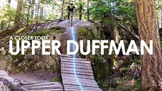
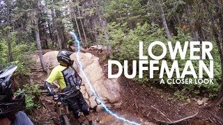
Videos
Recent Trail Reports Along Route
- By jimmimac
 WBP & contributors
 - #2397 - 1,600 views