
Open in App
Get this route on your phone instantly.
Als alternative kann man ganz bequem mit der Gondel bis Reuti hochfahren, damit spart man die eher steilen 400 Höhenmeter am Anfang der Runde. (Biketransport kein Problem)
Aufstieg bis Reuti auf Kiesstrasse, danach bis Winterlicken auf Belag.
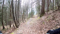
Super flowige Abfahrt Im Bereich Hundschipfi ist der Weg ein bisschen ausgesetzt, links geht es steil runter nach Äppigen.
We hope you've been enjoying Trailforks!
Create a FREE account to view route comments and much more.

Service Road Atlas is a free to use, community-driven service for viewing and creating reports on the numerous back-country service roads around B.C. and Alberta.
Save the current map location and zoom level as your default home location whenever this page is loaded.
Save| status | trail | date | condition | description |
|---|---|---|---|---|
Jul 18, 2024 @ 1:16am Jul 18, 2024 | ||||
Jul 18, 2024 @ 1:16am Jul 18, 2024 | ||||
Oct 12, 2023 @ 3:12am Oct 12, 2023 | ||||
Jul 18, 2020 @ 12:35am Jul 18, 2020 |