4,619 ft
Distance
-770 ft
Descent
00:06:45
Avg time
Supporters, Builders, Maintainers & Land Managers of 115 Trail
Finale Outdoor RegionLand Manager
115 Details
-
Activities
- Mountain Bike
- E-Bike
-
Riding AreaFinale Outdoor Region
Finale Ligure -
Ref Number#97
-
Difficulty Rating
-
Trail TypeDoubletrack
-
Bike TypeAM, XC, Gravel, Adaptive MTB
-
DirectionDownhill OnlyPopular direction shown
-
Climb DifficultyGreen
-
Physical RatingModerate
-
Trail VisibilityAlways easy to follow
-
SeasonAll-year round
-
Dogs AllowedYes
-
eBike AllowedYes up to Class 1
-
TTFs on TrailBerm
-
Ride in RainYes
-
Global Ranking
-
Local Popularity95 in Mountain Biking [+]
- 95 in E-Biking
-
Land ManagerFinale Outdoor Region
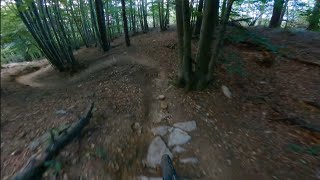
Among the three trails starting straight from the Nato Base, this is the on the right. Maybe the one slightly steeper and faster than them. It features a couple of drop-offs and a small jump. Nothing must be ridden, side lines are always there. It ends on the same gravel road crossed by Base Nato and Madre Natura.
Access Info
Nato Base Area is reachable from the E80 highway accessing Orco Feglino, then drive north on the SP23 until the windmills under the Base.
Disclaimer
Given its nature, the trail can change after weather happenings and season changes. Always pay attention.
Local Trail Association
-
Please consider joining or donating to the local trail association to supportdonate to earn trail karma!
trail development & maintenance.
More Stats for 115 mountain bike trail trail
-
Altitude change-770 ft
-
Altitude min2,511 ft
-
Altitude max3,282 ft
-
Altitude start3,282 ft
-
Altitude end2,513 ft
-
Grade-16.7%
-
Grade max-48.7%
-
Grade min-3.4%
-
Distance down4,619 ft
-
Avg time00:06:45
-
Avg reverse time00:08:53
- view trail stats
close
Trail Conditions
- Unknown
- Snow Groomed
- Snow Packed
- Snow Covered
- Snow Cover Inadequate
- Freeze/thaw Cycle
- Icy
- Prevalent Mud
- Wet
- Variable
- Ideal
- Dry
- Very Dry
Trail Flow (Ridden Direction)
Trailforks scans users ridelogs to determine the most popular direction each trail is ridden. A good flowing trail network will have most trails flowing in a single direction according to their intension.
The colour categories are based on what percentage of riders are riding a trail in its intended direction.
- > 96%
- > 90%
- > 80%
- > 70%
- > 50%
- < 50%
- bi-directional trail
- no data
Trail Last Ridden
Trailforks scans ridelogs to determine the last time a trail was ridden.
- < 2 days
- < 1 week
- < 2 weeks
- < 1 month
- < 6 months
- > 6 months
Trail Ridden Direction
The intended direction a trail should be ridden.
- Downhill Only
- Downhill Primary
- Both Directions
- Uphill Primary
- Uphill Only
- One Direction
Contribute Details
Colors indicate trail is missing specified detail.
- Description
- Photos
- Description & Photos
- Videos
Trail Popularity ?
Trailforks scans ridelogs to determine which trails are ridden the most in the last 9 months.
Trails are compared with nearby trails in the same city region with a possible 25 colour shades.
Think of this as a heatmap, more rides = more kinetic energy = warmer colors.
- most popular
- popular
- less popular
- not popular
ATV/ORV/OHV Filter
Max Vehicle Width
inches
Radar Time
x
Activity Recordings
Trailforks users anonymized public ridelogs from the past 6 months.
- mountain biking recent
- mountain biking (>6 month)
- hiking (1 year)
- moto (1 year)
Activity Recordings
Trailforks users anonymized public skilogs from the past 12 months.
- Downhill Ski
- Backcountry Ski
- Nordic Ski
Jump Magnitude Heatmap
Heatmap of where riders jump on trails. Zoom in to see individual jumps, click circles to view jump details.
Trails Deemphasized
Trails are shown in grey.
Only show trails with NO bikes.
Save the current map location and zoom level as your default home location whenever this page is loaded.
Save
Directions to 115 trailhead
(44.247970, 8.279180)
update trails status or condition
115 Trail Reports
view all reports »
Recent Ridelog Activity on Trail
Past Week
- 6 rides
- 23 miles avg distance
6 Months
- 425 rides
- 25 miles avg distance
All
- 2,110 rides
- Last: Aug 16, 2022
Photos
more »
Routes with this trail
6 Reviews & Comments
-
+ 0
Hitecdriver
(Oct 2, 2020 at 0:20)

Flowtrail. The upper part should be marked as green
[Reply]
BikeHarry
(Sep 5, 2018 at 9:12)
Super trail, mit allem was man braucht, jumps, drops Anlieger und garantiert nie langweilig
[Reply]

Great trail, very fast and full of features. Not a trail to warm up, though. Choose another one if it is your first ride around here.
[Reply]


Really nice fast trail with some jumps and lots of small to medium drops. Everything can be ridden over or around if needed.
[Reply]
Videos
more »
Nearby Trails
- Madre Natura 3 ft
- Base Nato 361 ft
- Crestino Pt. 1 361 ft
- H Trail 1,345 ft
- Colla San Giacomo Av 5,138 ft
Finale Outdoor Region
- embed 115 trail on your website
- By cheorch
& contributors
- #45897 - 7,346 views
- subscribe
- login to download gpx or kml files.