


Open in App
Get this trail on your phone instantly.

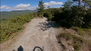
One of the first trails built in the Nato Base area. The longest trail of the 4 that roll down straight from the Base itself, and one of the most fun. Fast lines, banks, tiny jumps and a lot of flow, definitely a must-ride of the area. The cool scenery of the Nato Base is a great introduction to the very fun trails that lay ahead.
Nato Base Area is reachable from the E80 highway accessing Orco Feglino, then drive north on the SP23 until the windmills under the Base.
Slow down at the gravel road crossings. Given its nature, the trail can change after weather happenings and season changes. Always pay attention.
| c1 | c2 | c3 | c4 |
|---|---|---|---|
January | February | March | April |
May | June | July | August |
September | October | November | December |

Service Road Atlas is a free to use, community-driven service for viewing and creating reports on the numerous back-country service roads around B.C. and Alberta.
Save the current map location and zoom level as your default home location whenever this page is loaded.
SaveWe hope you've been enjoying Trailforks!
Create a FREE account to view trail comments and much more.
You must enter a description before submitting.

