1.4 miles
Distance
7 ft
Climb
-1,355 ft
Descent
00:10:10
Avg time
Supporters, Builders, Maintainers & Land Managers of 1-2-3 Trail
Freerida
since 2015Builder
1-2-3 Details
-
Activities
- Mountain Bike
- E-Bike
-
Riding AreaSober trail park
Krasnodar -
AKAтрейл Бочанского
-
Difficulty Rating
-
Trail TypeSingletrack
-
Bike TypeDH, AM
-
DirectionDownhill OnlyPopular direction shown
-
Physical RatingModerate
-
Seasonapr-nov
-
Dogs AllowedYes
-
eBike Allowed
-
TTFs on TrailBerm, Drop, Jump, Gap Jump, Pump Track, Rock Face, Rock Garden
-
Global Ranking#15225 in Mountain Biking
-
Local Popularity90 in Mountain Biking [+]
- 95 in E-Biking
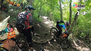
Новая “синяя” трасса построена осенью 2015 года. Особенность трассы в том, что она идёт траверсом очень крутого склона, постоянно поворачивая на 180 градусов. Множество «свитчбэков» сменяются скоростным участком с небольшими трамплинами. 123 стыкуется со всеми «зелеными» трассами. От того имеет такое название. Но можно не съезжать на “зеленые ветки”, а продолжить ехать по очень рельефному продолжению 123. Финиширует трейл в глубокой балке, откуда, используя перегон, можно добраться к трейлам Каменный ручей, Ночной СУ, Финишный спуск или попасть в Скилл-зону, либо сразу с финиша стартануть Фэншуй.
More Stats for 1-2-3 mountain bike trail trail
-
Altitude change-1,348 ft
-
Altitude min954 ft
-
Altitude max2,302 ft
-
Altitude start2,302 ft
-
Altitude end955 ft
-
Grade-18.4%
-
Grade max-114.2%
-
Grade min8.6%
-
Distance climb105 ft
-
Distance down1 mile
-
Distance flat184 ft
-
Avg time00:10:10
- view trail stats
close
3D
Trail Conditions
- Unknown
- Snow Groomed
- Snow Packed
- Snow Covered
- Snow Cover Inadequate
- Freeze/thaw Cycle
- Icy
- Prevalent Mud
- Wet
- Variable
- Ideal
- Dry
- Very Dry
Trail Flow (Ridden Direction)
Trailforks scans users ridelogs to determine the most popular direction each trail is ridden. A good flowing trail network will have most trails flowing in a single direction according to their intension.
The colour categories are based on what percentage of riders are riding a trail in its intended direction.
- > 96%
- > 90%
- > 80%
- > 70%
- > 50%
- < 50%
- bi-directional trail
- no data
Trail Last Ridden
Trailforks scans ridelogs to determine the last time a trail was ridden.
- < 2 days
- < 1 week
- < 2 weeks
- < 1 month
- < 6 months
- > 6 months
Trail Ridden Direction
The intended direction a trail should be ridden.
- Downhill Only
- Downhill Primary
- Both Directions
- Uphill Primary
- Uphill Only
- One Direction
Contribute Details
Colors indicate trail is missing specified detail.
- Description
- Photos
- Description & Photos
- Videos
Trail Popularity ?
Trailforks scans ridelogs to determine which trails are ridden the most in the last 9 months.
Trails are compared with nearby trails in the same city region with a possible 25 colour shades.
Think of this as a heatmap, more rides = more kinetic energy = warmer colors.
- most popular
- popular
- less popular
- not popular
ATV/ORV/OHV Filter
Max Vehicle Width
inches
Radar Time
x
Activity Recordings
Trailforks users anonymized public ridelogs from the past 6 months.
- mountain biking recent
- mountain biking (>6 month)
- hiking (1 year)
- moto (1 year)
Activity Recordings
Trailforks users anonymized public skilogs from the past 12 months.
- Downhill Ski
- Backcountry Ski
- Nordic Ski
- Snowmobile
Jump Magnitude Heatmap
Heatmap of where riders jump on trails. Zoom in to see individual jumps, click circles to view jump details.
Trails Deemphasized
Trails are shown in grey.
Only show trails with NO bikes.
Save the current map location and zoom level as your default home location whenever this page is loaded.
Save
Directions to 123 trailhead
(44.698510, 38.565420)
update trails status or condition
1-2-3 Trail Reports
view all reports »
Recent Ridelog Activity on Trail
Past Week
- 0 rides
6 Months
- 21 rides
- 27 miles avg distance
All
- 174 rides
- Last: Jan 21, 2023
Routes with this trail
Nearby Trails
- Хэндмэйд 118 ft
- Скверная 174 ft
- Фантом 1,640 ft
- В обход заборов 1,680 ft
- Старая красная 2,421 ft
- embed 1-2-3 trail on your website
- By DrumminMan TBRU & contributors
- #49456 - 1,176 views
- subscribe
- login to download gpx or kml files.