more stats
1.5 miles
Distance
-523 ft
Descent
00:16:13
Avg time
-523 ft
Altitude change
4,150 ft
Altitude min
4,674 ft
Altitude max
4,674 ft
Altitude start
4,150 ft
Altitude end
-6.4%
Grade
-19.1%
Grade max
1.1%
Grade min
2 miles
Distance down
00:16:13
Avg time

6000 Steps Details

  • Activities
    • Mountain Bike
    • Hike
    • Trail Running
  • Riding Area
    Snowshoe Backcountry
    Snowshoe Village, West Virginia
  • Difficulty Rating
  • Local Popularity
    75 in Mountain Biking [+]
    • 100 in Trail Running
    • 80 in Hiking
  • Global Ranking
    #64665 in Mountain Biking [+]
    • #12923 in Trail Running
    • #43145 in Hiking
  • Trail Type
    Mixed
  • Bike Type
    AM, XC
  • Direction
    Downhill Primary
    Popular Direction Shown
  • Physical Rating
    Moderate
  • Season
    June - October
  • Dogs Allowed
    Yes
  • eBike Allowed
  • Land Owner

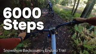
6000 Steps is a great Backcountry Trail for the emerging MTB enthusiast. Offering a mix of roots, rocks, and off camber; this trail eventually meets with an old Rail Grade. Riders will have a creek crossing and then exit by Soaring Eagle Lift. Following the Shavers Lake Access Trail will get Riders back to Ballhooter Lift.

Access Info

Riders can take Double Track Access Road on Cheat Mnt Ridge Trail from Top of the World. Keep your eyes open for the Backcountry Trail marker for "6000 Steps" on the left. Singletrack access to this trail can be achieved by taking "Bear Skat" to "Unemployment Highway."

Local Trail Association
Traditionally Indigenous Territory

Recent Activity on Trail

Past Week
  • 0 rides
  •  
6 Months
  • 6 rides
  • 18 miles avg distance
All
  • 105 rides
  • Last: Jun 21, 2026
c1c2c3c4
January
February
March
April
May
June
July
August
September
October
November
December
Status:
on Jun 12, 2026
Wet
Avg: 4.07 (6 votes)
Your vote: 0

view (805)
close
3D
Trail Conditions
  • Unknown
  • Snow Groomed
  • Snow Packed
  • Snow Covered
  • Snow Cover Partial
  • Freeze/thaw Cycle
  • Icy
  • Prevalent Mud
  • Wet
  • Variable
  • Ideal
  • Dry
  • Very Dry
Trail Flow (Ridden Direction)
Trailforks scans users ridelogs to determine the most popular direction each trail is ridden. A good flowing trail network will have most trails flowing in a single direction according to their intension.
The colour categories are based on what percentage of riders are riding a trail in its intended direction.
  • > 96%
  • > 90%
  • > 80%
  • > 70%
  • > 50%
  • < 50%
  • bi-directional trail
  • no data
Trail Last Ridden
Trailforks scans ridelogs to determine the last time a trail was ridden.
  • < 2 days
  • < 1 week
  • < 2 weeks
  • < 1 month
  • < 6 months
  • > 6 months
Trail Ridden Direction
The intended direction a trail should be ridden.
  • Downhill Only
  • Downhill Primary
  • Both Directions
  • Uphill Primary
  • Uphill Only
  • One Direction
Contribute Details
Colors indicate trail is missing specified detail.
  • Description
  • Photos
  • Description & Photos
  • Videos
Trail Popularity ?
Trailforks scans ridelogs to determine which trails are ridden the most in the last 9 months. Trails are compared with nearby trails in the same city region with a possible 25 colour shades. Think of this as a heatmap, more rides = more kinetic energy = warmer colors.
  • most popular
  • popular
  • less popular
  • not popular
ATV/ORV/OHV Filter
Max Vehicle Width
inches
US Cell Coverage
Legend
cell carrier legend

Radar Time
Activity Recordings
Trailforks uses anonymized public activity data. ?
Activity Recordings
Trailforks uses anonymized public activity data. ?
Personal Heatmap
Activity Types
all / none
Options
2
Date range month
Winter Trails
Warning A routing network for winter maps does not exist. Selecting trails using the winter trails layer has been disabled.
Missing Trails
Most Popular
Least Popular
Trails are colored based on popularity. The more popular a trail is, the more red. Less popular trails trend towards green.
Jump Magnitude Heatmap
Heatmap of where riders jump on trails. Zoom in to see individual jumps, click circles to view jump details.
BC Backroad Status

Service Road Atlas is a free to use, community-driven service for viewing and creating reports on the numerous back-country service roads around B.C. and Alberta.

map legend
Slope Aspect
Direction the slope faces
Flat N NE E SE S SW W NW
Trails Deemphasized
Trails are shown in grey.
disable
Only show trails with no bike usage.
Enable
Suggested Layers
Based on selected activity type

    Save the current map location and zoom level as your default home location whenever this page is loaded.

    Save
        Directions to 6000-steps trailhead (38.409140, -79.968830)

        Photos

        9 more »
        391 |
        Jun 27, 2015 @ 2:17pm
        Jun 27, 2015
        568 |
        Jun 27, 2015 @ 2:17pm
        Jun 27, 2015
        442 |
        Jun 27, 2015 @ 2:17pm
        Jun 27, 2015
        673 |
        Jun 27, 2015 @ 2:17pm
        Jun 27, 2015

        Videos

        2 more »
        Conquering 6000 Steps! | 4K POV with Elodie...
        5:12 | 172 | Nov 17, 2024 , Snowshoe Village
        2015 Snowshoe EPIC Enduro
        4:27 | 2343 | Jul 2, 2015 , Snowshoe Village

        Routes with this trail

        11 miles 812 ft 23
        Snowshoe Back Country Route
        23 miles 3,571 ft 16 Loop Race
        Stage 1- Access to next Stage- Ballhooter Lift, to top of M Stage 2- M & O Access to next Stage- Pedal to...

        2 Reviews & Comments


        We hope you've been enjoying Trailforks!

        Create a FREE account to view trail comments and much more.

        • By rsdobbins & contributors
        • #7256 - 5,467 views

        Frequently Asked Questions About 6000 Steps

        Where is 6000 Steps located?
        6000 Steps is located in Snowshoe Backcountry, Snowshoe Village, West Virginia, United States. It is part of the Snowshoe Backcountry trail network. The trailhead is located at coordinates 38.40914, -79.96883.
        How hard is 6000 Steps?
        6000 Steps is rated as Blue difficulty. The physical rating is Moderate. The average grade is 6.4%.
        What is the elevation gain for 6000 Steps?
        The trail has 523 ft of elevation descent. The elevation ranges from 4,150 ft to 4,674 ft.
        Is 6000 Steps a point to point trail?
        6000 Steps is not a point to point trail. The direction is Downhill Primary. The trail type is mixed.

        Hit the Trail

        Open in App

        Get this trail on your phone instantly.
        open trail in app

        Download Trail

        Save to wishlist, Garmin & download.
        save the trail

        Find Related Routes

        Find routes and users activities that include this trail.
        find routes for this trail

        You must enter a description before submitting.