2,441 ft
Distance
-163 ft
Descent
00:02:15
Avg time
7 Seconds Details
-
Activities
- Mountain Bike
- E-Bike
- Horse
- Hike
- Trail Running
- Dirtbike/Moto
- Observed Trials
- Snowshoe
-
Riding AreaTyaughton Lake
Gold Bridge, British Columbia -
Difficulty Rating
-
Trail TypeSingletrack
-
Bike TypeAM, XC
-
DirectionDownhill PrimaryPopular direction shown
-
Climb DifficultyDouble Black Diamond
-
Physical RatingModerate
-
Trail VisibilityAlways easy to follow
-
Dogs AllowedYes
-
eBike AllowedYes up to Class 1
-
Global Ranking
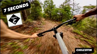
A short fun multi-use trail taking you from the Dry Waterline to Gun Creek Rd. with nice views along the way.
Horses and motorcycles occasionally travelling uphill. Dusty in dry periods, downhill recommended via moto during these periods. Please avoid locking wheels in corners, pumice soil is loose and very sensitive and will rut out badly.
Local Trail Association
-
Please consider joining or donating to the local trail association to supportdonate to earn trail karma!
trail development & maintenance.
Traditionally Indigenous Territory
More Stats for 7 Seconds multi-use trail trail
-
Altitude change-163 ft
-
Altitude min2,832 ft
-
Altitude max2,994 ft
-
Altitude start2,994 ft
-
Altitude end2,831 ft
-
Grade-6.7%
-
Grade max-39.6%
-
Grade min3.3%
-
Distance climb69 ft
-
Distance down1,949 ft
-
Distance flat423 ft
-
Avg time00:02:15
-
Avg reverse time00:10:23
- view trail stats
close
3D
Trail Conditions
- Unknown
- Snow Groomed
- Snow Packed
- Snow Covered
- Snow Cover Inadequate
- Freeze/thaw Cycle
- Icy
- Prevalent Mud
- Wet
- Variable
- Ideal
- Dry
- Very Dry
Trail Flow (Ridden Direction)
Trailforks scans users ridelogs to determine the most popular direction each trail is ridden. A good flowing trail network will have most trails flowing in a single direction according to their intension.
The colour categories are based on what percentage of riders are riding a trail in its intended direction.
- > 96%
- > 90%
- > 80%
- > 70%
- > 50%
- < 50%
- bi-directional trail
- no data
Trail Last Ridden
Trailforks scans ridelogs to determine the last time a trail was ridden.
- < 2 days
- < 1 week
- < 2 weeks
- < 1 month
- < 6 months
- > 6 months
Trail Ridden Direction
The intended direction a trail should be ridden.
- Downhill Only
- Downhill Primary
- Both Directions
- Uphill Primary
- Uphill Only
- One Direction
Contribute Details
Colors indicate trail is missing specified detail.
- Description
- Photos
- Description & Photos
- Videos
Trail Popularity ?
Trailforks scans ridelogs to determine which trails are ridden the most in the last 9 months.
Trails are compared with nearby trails in the same city region with a possible 25 colour shades.
Think of this as a heatmap, more rides = more kinetic energy = warmer colors.
- most popular
- popular
- less popular
- not popular
ATV/ORV/OHV Filter
Max Vehicle Width
inches
Radar Time
x
Activity Recordings
Trailforks users anonymized public ridelogs from the past 6 months.
- mountain biking recent
- mountain biking (>6 month)
- hiking (1 year)
- moto (1 year)
Activity Recordings
Trailforks users anonymized public skilogs from the past 12 months.
- Downhill Ski
- Backcountry Ski
- Nordic Ski
- Snowmobile
Winter Trails
Warning
A routing network for winter maps does not exist. Selecting trails using the winter trails layer has been disabled.
x
Missing Trails
Most Popular
Least Popular
Trails are colored based on popularity. The more popular a trail is, the more red. Less popular trails trend towards green.
Jump Magnitude Heatmap
Heatmap of where riders jump on trails. Zoom in to see individual jumps, click circles to view jump details.
Trails Deemphasized
Trails are shown in grey.
Only show trails with NO bikes.
Save the current map location and zoom level as your default home location whenever this page is loaded.
Save
Directions to 7-seconds trailhead
(50.919380, -122.806210)
update trails status or condition
7 Seconds Trail Reports
view all reports »
Recent Ridelog Activity on Trail
Past Week
- 0 rides
6 Months
- 11 rides
- 15 miles avg distance
All
- 192 rides
- Last: Jul 12, 2023
Photos
more »
Routes with this trail
We hope you've been enjoying Trailforks!
Create a FREE account to view trail comments and much more.
Videos
no videos have been added for 7 Seconds yet, add a video.
Nearby Trails
- Dry Waterline Trail 528 ft
- Packer D 2,956 ft
- Telegraph Trail Connector 3,524 ft
- James And Jackie 4,042 ft
- Mainline 4,764 ft
- By canadaka
Trailforks & contributors
- #23915 - 2,012 views
- subscribe
- login to download gpx or kml files.