more stats
1,115 ft
Distance
-77 ft
Descent
00:01:32
Avg time
-77 ft
Altitude change
408 ft
Altitude min
486 ft
Altitude max
486 ft
Altitude start
410 ft
Altitude end
-6.9%
Grade
-12.8%
Grade max
1,050 ft
Distance down
66 ft
Distance flat
00:01:32
Avg time

ACC Details

  • Activities
    • Mountain Bike
  • Riding Area
    Parihaka MTB Park
    Whangarei
  • Difficulty Rating
  • Voted Difficulty
    Black Diamond (3 votes)
  • Local Popularity
    80 in Mountain Biking
  • Global Ranking
    #8395 in Mountain Biking
  • Trail Type
    Singletrack
  • Direction
    Downhill Only
    Popular Direction Shown
  • Climb Difficulty
    Green
  • Physical Rating
    Moderate
  • Trail Visibility
    Always easy to follow
  • Season
    Jan-Dec
  • Dogs Allowed
    Yes
  • TTFs on Trail
    Berm, Bridge, Drop
  • Ride in Rain
    Yes
  • Year Opened
    2022
  • Land Owner
    Whangarei Mountain Bike Club

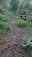
ACC can be accessed by either Bully or Link to Bully / Resurrection. Best access for a bit more speed into the trail is by making the effort to ride up to the top of Jpin. Acc is a single track that takes you to the bottom of the park. It has some small steps that are rollable. A rollover bridge that is man made is half way down the trail. (Bridge turns to your right) The trail eventually crosses White Tail (Keep an ear out for other riders). This is the most technical part of the trail as it is off camber and a lot steeper than the rest of the trail. There is a large berm to rail at the bottom then the trail flattens off to join onto the bottom of Jpin.

Access Info

Bully or Link to Bully / Resurrection

Disclaimer

Trail crosses White Tail please take care.

Local Trail Association
Traditionally Indigenous Territory

Recent Activity on Trail

Past Week
  • 0 rides
  •  
6 Months
  • 1 rides
  • 9 miles avg distance
All
  • 112 rides
  • Last: Jun 11, 2026
c1c2c3c4
January
February
March
April
May
June
July
August
September
October
November
December
update trails status or condition

ACC Trail Reports

statusdatedescription
Apr 27, 2026 @ 12:59pm (Pacific/Auckland)
Apr 26, 2026
Not to bad, quite slippery white clay after a rain
Jan 8, 2026 @ 9:37pm (Pacific/Auckland)
Jan 8, 2026
Running good but all the leaves make it slow and slippy
Feb 8, 2024 @ 11:37pm
Feb 8, 2024
One of my favourites. Rough and ready.
Feb 7, 2024 @ 6:01pm
Feb 7, 2024
too many optional lines and side trails, who knows what is what, I like this trail though in spite of the dangerous green trail crossing
Feb 3, 2024 @ 1:33am
Feb 3, 2024
Fun track! Probably more of a (typical) grade 4 though.
more »
Status:
on Apr 27, 2026
Wet
Avg: 3.86 (2 votes)
Your vote: 0

view (546)
close
3D
Trail Conditions
  • Unknown
  • Snow Groomed
  • Snow Packed
  • Snow Covered
  • Snow Cover Partial
  • Freeze/thaw Cycle
  • Icy
  • Prevalent Mud
  • Wet
  • Variable
  • Ideal
  • Dry
  • Very Dry
Trail Flow (Ridden Direction)
Trailforks scans users ridelogs to determine the most popular direction each trail is ridden. A good flowing trail network will have most trails flowing in a single direction according to their intension.
The colour categories are based on what percentage of riders are riding a trail in its intended direction.
  • > 96%
  • > 90%
  • > 80%
  • > 70%
  • > 50%
  • < 50%
  • bi-directional trail
  • no data
Trail Last Ridden
Trailforks scans ridelogs to determine the last time a trail was ridden.
  • < 2 days
  • < 1 week
  • < 2 weeks
  • < 1 month
  • < 6 months
  • > 6 months
Trail Ridden Direction
The intended direction a trail should be ridden.
  • Downhill Only
  • Downhill Primary
  • Both Directions
  • Uphill Primary
  • Uphill Only
  • One Direction
Contribute Details
Colors indicate trail is missing specified detail.
  • Description
  • Photos
  • Description & Photos
  • Videos
Trail Popularity ?
Trailforks scans ridelogs to determine which trails are ridden the most in the last 9 months. Trails are compared with nearby trails in the same city region with a possible 25 colour shades. Think of this as a heatmap, more rides = more kinetic energy = warmer colors.
  • most popular
  • popular
  • less popular
  • not popular
ATV/ORV/OHV Filter
Max Vehicle Width
inches
US Cell Coverage
Legend
cell carrier legend

Radar Time
Activity Recordings
Trailforks uses anonymized public activity data. ?
Activity Recordings
Trailforks uses anonymized public activity data. ?
Personal Heatmap
Activity Types
all / none
Options
2
Date range month
Winter Trails
Warning A routing network for winter maps does not exist. Selecting trails using the winter trails layer has been disabled.
Missing Trails
Most Popular
Least Popular
Trails are colored based on popularity. The more popular a trail is, the more red. Less popular trails trend towards green.
Jump Magnitude Heatmap
Heatmap of where riders jump on trails. Zoom in to see individual jumps, click circles to view jump details.
BC Backroad Status

Service Road Atlas is a free to use, community-driven service for viewing and creating reports on the numerous back-country service roads around B.C. and Alberta.

map legend
Slope Aspect
Direction the slope faces
Flat N NE E SE S SW W NW
Trails Deemphasized
Trails are shown in grey.
disable
Only show trails with no bike usage.
Enable
Suggested Layers
Based on selected activity type

    Save the current map location and zoom level as your default home location whenever this page is loaded.

    Save
        Directions to acc trailhead (-35.706570, 174.350750)

        Photos

        2 more »
        42 |
        Nov 26, 2022 @ 3:02pm
        Nov 26, 2022

        Videos

        1 more »
        Acc drop
        0:06 | 37 | Feb 21, 2024 , Whangarei

        Routes with this trail

        5.0 5 miles 863 ft 16
        First Whanageri MTB Club weekly ride.

        1 Review & Comments


        We hope you've been enjoying Trailforks!

        Create a FREE account to view trail comments and much more.

        • By DaveBeazleyTF Pro & contributors
        • #589042 - 435 views

        Frequently Asked Questions About ACC

        Where is ACC located?
        ACC is located in Parihaka MTB Park, Whangarei, New Zealand. It is part of the Parihaka MTB Park trail network. The trailhead is located at coordinates -35.70657, 174.35075.
        How hard is ACC?
        ACC is rated as Blue difficulty. The physical rating is Moderate. The average grade is 6.9%. The climb difficulty is rated Green.
        What is the elevation gain for ACC?
        The trail has 77 ft of elevation descent. The elevation ranges from 408 ft to 486 ft.
        Is ACC a point to point trail?
        Yes, ACC is a point to point trail. The direction is Downhill Only. The trail type is singletrack.

        Hit the Trail

        Open in App

        Get this trail on your phone instantly.
        open trail in app

        Download Trail

        Save to wishlist, Garmin & download.
        save the trail

        Find Related Routes

        Find routes and users activities that include this trail.
        find routes for this trail

        You must enter a description before submitting.