3.9 miles
Distance
545 ft
Climb
-941 ft
Descent
00:32:49
Avg time
Supporters, Builders, Maintainers & Land Managers of Alaska Trail

Alaska Details

  • Activities
    • Mountain Bike
    • Hike
    • Trail Running
  • Riding Area
    Klondike Bluffs
    Moab, Utah
  • Difficulty Rating
  • Voted Difficulty
    Blue (1 vote)
  • Trail Type
    Singletrack
  • Direction
    Both Directions
    Popular direction shown
  • Dogs Allowed
    Yes
  • eBike Allowed
  • Global Ranking
    #1301 in Mountain Biking [+]
    • #25340 in Trail Running
    • #22256 in Hiking
  • Local Popularity
    85 in Mountain Biking [+]
    • 5 in Trail Running
    • 55 in Hiking
  • Land Owner
    BLM

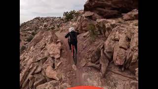
This trail was fun in spots and the scenery is very good but it definitely not all down and not all flow. There are some flowy sections that navigate you through some big boulders, and some sections where the slick rock has some hard edges and can be a rough ride on a hard tail. Fun cross country type trail to train and enjoy the unique landscape.

Local Trail Association
Traditionally Indigenous Territory
More Stats for Alaska mountain bike trail trail
  • Altitude change
    -395 ft
  • Altitude min
    4,850 ft
  • Altitude max
    5,333 ft
  • Altitude start
    5,247 ft
  • Altitude end
    4,851 ft
  • Grade
    -1.939%
  • Grade max
    -88.818%
  • Grade min
    69.616%
  • Distance climb
    1 mile
  • Distance down
    2 miles
  • Distance flat
    2,772 ft
  • Avg time
    00:32:49
  • Avg reverse time
    01:04:23
  • view trail stats
Status:
on Apr 28, 2025
Ideal
Avg: 4.42 (60 votes)
Your vote: 0

view (2,940)
close
3D
Trail Conditions
  • Unknown
  • Snow Groomed
  • Snow Packed
  • Snow Covered
  • Snow Cover Partial
  • Freeze/thaw Cycle
  • Icy
  • Prevalent Mud
  • Wet
  • Variable
  • Ideal
  • Dry
  • Very Dry
Trail Flow (Ridden Direction)
Trailforks scans users ridelogs to determine the most popular direction each trail is ridden. A good flowing trail network will have most trails flowing in a single direction according to their intension.
The colour categories are based on what percentage of riders are riding a trail in its intended direction.
  • > 96%
  • > 90%
  • > 80%
  • > 70%
  • > 50%
  • < 50%
  • bi-directional trail
  • no data
Trail Last Ridden
Trailforks scans ridelogs to determine the last time a trail was ridden.
  • < 2 days
  • < 1 week
  • < 2 weeks
  • < 1 month
  • < 6 months
  • > 6 months
Trail Ridden Direction
The intended direction a trail should be ridden.
  • Downhill Only
  • Downhill Primary
  • Both Directions
  • Uphill Primary
  • Uphill Only
  • One Direction
Contribute Details
Colors indicate trail is missing specified detail.
  • Description
  • Photos
  • Description & Photos
  • Videos
Trail Popularity ?
Trailforks scans ridelogs to determine which trails are ridden the most in the last 9 months. Trails are compared with nearby trails in the same city region with a possible 25 colour shades. Think of this as a heatmap, more rides = more kinetic energy = warmer colors.
  • most popular
  • popular
  • less popular
  • not popular
ATV/ORV/OHV Filter
Max Vehicle Width
inches
US Cell Coverage
Legend
cell carrier legend

Radar Time
x Activity Recordings
Trailforks users anonymized public ridelogs from the past 6 months.
  • mountain biking recent
  • mountain biking (>6 month)
  • hiking (1 year)
  • moto (1 year)
Activity Recordings
Trailforks users anonymized public skilogs from the past 12 months.
  • Downhill Ski
  • Backcountry Ski
  • Nordic Ski
  • Snowmobile
Winter Trails
Warning A routing network for winter maps does not exist. Selecting trails using the winter trails layer has been disabled.
x Missing Trails
Most Popular
Least Popular
Trails are colored based on popularity. The more popular a trail is, the more red. Less popular trails trend towards green.
Jump Magnitude Heatmap
Heatmap of where riders jump on trails. Zoom in to see individual jumps, click circles to view jump details.
Trails Deemphasized
Trails are shown in grey.
disable
Only show trails with NO bikes.
enable

Save the current map location and zoom level as your default home location whenever this page is loaded.

Save
      Directions to alaska trailhead (38.834890, -109.737070)

      Recent Ridelog Activity on Trail

      Past Week
      • 1 rides
      • 14 miles avg distance
      6 Months
      • 69 rides
      • 12 miles avg distance
      All
      • 627 rides
      • Last: May 8, 2025

      Photos

      more »
      1,073 |
      May 23, 2014 @ 10:04pm
      May 23, 2014
      716 |
      Oct 18, 2017 @ 2:28am
      Oct 18, 2017
      697 |
      Jun 26, 2017 @ 7:46am
      Jun 26, 2017
      8 |
      Apr 13, 2025 @ 12:16pm
      Apr 13, 2025

      Routes with this trail

      more »
      titledistance
      Klondike Bluffs Circuit17 miles
      Tour de Klondike revised24 miles
      Super fun Klondike ride!11 miles
      Klondike - Jurassic to Baby Steps Loop19 miles

      8 Reviews & Comments


      We hope you've been enjoying Trailforks!

      Create a FREE account to view trail comments and much more.

      Videos

      more »
      youtuber Alaska & Other Trails 2018 (Moab, UT)...
      12:39 | 888 | Jun 8, 2018 , Moab
      youtuber Mountain Biking Alaska and Homer, North...
      13:43 | 774 | Dec 11, 2017 , Moab
      9 year old leading Alaska, Klondike Bluffs...
      23:07 | 16 | Apr 15, 2025 , Moab
      Alaska - From Mega Steps to Homer
      11:01 | 46 | Jul 13, 2024 , Moab

      Nearby Trails

      • By toddTF Pro Trailforks & contributors
      • #8993 - 9,286 views

      You must enter a description before submitting.