



Open in App
Get this trail on your phone instantly.

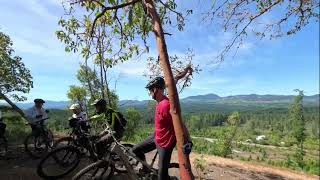
Ride-able both directions, best way seems to be from end of schadenfreude on your right. Starts on easy old single track decommissioned road, then goes through a few wet sections then ascends a mild slope onto a nice ridge with some steep drop offs on your left, watch your track on what some might consider a few intimidating drop offs as the trail follows the cliff line.As the cliffs descend in height the trail veers away and into the forest eventually coming out on an old bushy road and back towards Schadenfreude.
This trail is unsanctioned.
Ride at your own risk

Service Road Atlas is a free to use, community-driven service for viewing and creating reports on the numerous back-country service roads around B.C. and Alberta.
Save the current map location and zoom level as your default home location whenever this page is loaded.
SaveWe hope you've been enjoying Trailforks!
Create a FREE account to view all trail reviews and much more.
You must enter a description before submitting.

