more stats
5.4 miles
Distance
466 ft
Climb
-455 ft
Descent
01:03:15
Avg time
11 ft
Altitude change
4,183 ft
Altitude min
4,334 ft
Altitude max
4,233 ft
Altitude start
4,245 ft
Altitude end
-38%
Grade max
33.4%
Grade min
2 miles
Distance climb
2 miles
Distance down
1 mile
Distance flat
01:03:15
Avg time

Athena Details

  • Activities
    • Mountain Bike
    • E-Bike
    • Hike
    • Trail Running
  • Riding Area
    Missile Base
    Green River, Utah
  • Difficulty Rating
  • Local Popularity
    100 in Mountain Biking [+]
    • 5 in Trail Running
    • 80 in Hiking
  • Global Ranking
    #25277 in Mountain Biking [+]
    • #116421 in Trail Running
    • #1310 in Hiking
  • Trail Type
    Singletrack
  • Climb Difficulty
    Blue
  • Physical Rating
    Moderate
  • Dogs Allowed
    Yes
  • eBike Allowed
    Yes up to Class 1
  • Land Owner
    City of Green River

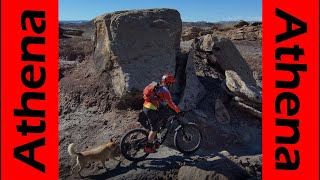
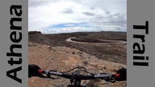
The first in hopefully a long line of official trails in Green River. Now you can stop off early on your way to Moab and get in some great cross country miles, with beautiful views of the river. Mostly pretty buff singletrack with some little rocky sections and minor exposure. But the trail is out in the open, so prepare for sun and some windy days.

Trail Supporters
Local Trail Association
Traditionally Indigenous Territory

Recent Activity on Trail

Past Week
  • 2 rides
  • 6 miles average
6 Months
  • 12 rides
  • 6 miles avg distance
All
  • 75 rides
  • Last: Jun 28, 2026
c1c2c3c4
January
February
March
April
May
June
July
August
September
October
November
December
update trails status or condition

Athena Trail Reports

statusdatedescription
May 25, 2026 @ 11:24am (America/Denver)
May 25, 2026
A great Moab-style ride. Route-finding is tricky in spots. This trail deserves more traffic.
Apr 18, 2026 @ 12:06pm (America/Denver)
Apr 18, 2026
Feb 15, 2026 @ 3:37pm (America/Denver)
Feb 15, 2026
Better than I’d imagined! Don’t let the 1st mile trick you. It’s not a boring ride in the desert. You’ll see some cool boulder fields and...
Apr 8, 2025 @ 6:39pm
Apr 8, 2025
Feb 18, 2025 @ 12:02pm
Feb 18, 2025
Excellent trail condition.
more »
Status:
on May 25, 2026
Dry
Avg: 3.68 (13 votes)
Your vote: 0

view (571)
close
3D
Trail Conditions
  • Unknown
  • Snow Groomed
  • Snow Packed
  • Snow Covered
  • Snow Cover Partial
  • Freeze/thaw Cycle
  • Icy
  • Prevalent Mud
  • Wet
  • Variable
  • Ideal
  • Dry
  • Very Dry
Trail Flow (Ridden Direction)
Trailforks scans users ridelogs to determine the most popular direction each trail is ridden. A good flowing trail network will have most trails flowing in a single direction according to their intension.
The colour categories are based on what percentage of riders are riding a trail in its intended direction.
  • > 96%
  • > 90%
  • > 80%
  • > 70%
  • > 50%
  • < 50%
  • bi-directional trail
  • no data
Trail Last Ridden
Trailforks scans ridelogs to determine the last time a trail was ridden.
  • < 2 days
  • < 1 week
  • < 2 weeks
  • < 1 month
  • < 6 months
  • > 6 months
Trail Ridden Direction
The intended direction a trail should be ridden.
  • Downhill Only
  • Downhill Primary
  • Both Directions
  • Uphill Primary
  • Uphill Only
  • One Direction
Contribute Details
Colors indicate trail is missing specified detail.
  • Description
  • Photos
  • Description & Photos
  • Videos
Trail Popularity ?
Trailforks scans ridelogs to determine which trails are ridden the most in the last 9 months. Trails are compared with nearby trails in the same city region with a possible 25 colour shades. Think of this as a heatmap, more rides = more kinetic energy = warmer colors.
  • most popular
  • popular
  • less popular
  • not popular
ATV/ORV/OHV Filter
Max Vehicle Width
inches
US Cell Coverage
Legend
cell carrier legend

Radar Time
Activity Recordings
Trailforks uses anonymized public activity data. ?
Activity Recordings
Trailforks uses anonymized public activity data. ?
Personal Heatmap
Activity Types
all / none
Options
2
Date range month
Winter Trails
Warning A routing network for winter maps does not exist. Selecting trails using the winter trails layer has been disabled.
Missing Trails
Most Popular
Least Popular
Trails are colored based on popularity. The more popular a trail is, the more red. Less popular trails trend towards green.
Jump Magnitude Heatmap
Heatmap of where riders jump on trails. Zoom in to see individual jumps, click circles to view jump details.
BC Backroad Status

Service Road Atlas is a free to use, community-driven service for viewing and creating reports on the numerous back-country service roads around B.C. and Alberta.

map legend
Slope Aspect
Direction the slope faces
Flat N NE E SE S SW W NW
Trails Deemphasized
Trails are shown in grey.
disable
Only show trails with no bike usage.
Enable
Suggested Layers
Based on selected activity type

    Save the current map location and zoom level as your default home location whenever this page is loaded.

    Save
        Directions to athena trailhead (38.967890, -110.123950)

        Photos

        30 more »
        80 |
        Feb 18, 2025 @ 9:14pm
        Feb 18, 2025
        320 |
        Mar 7, 2020 @ 4:50pm
        Mar 7, 2020
        333 |
        Jun 15, 2019 @ 6:37pm
        Jun 15, 2019
        312 |
        Jun 15, 2019 @ 6:37pm
        Jun 15, 2019

        Videos

        2 more »
        youtuber Athena Trail: What Riding Mars Would Look Like!
        21:36 | 489 | Mar 10, 2021 , Green River
        youtuber Desert Cruising on Athena Trail!
        13:44 | 319 | Feb 23, 2021 , Green River

        27 Reviews & Comments


        We hope you've been enjoying Trailforks!

        Create a FREE account to view trail comments and much more.

        • By toddTF Pro Trailforks & contributors
        • #122655 - 5,797 views

        Frequently Asked Questions About Athena

        Where is Athena located?
        Athena is located in Missile Base, Green River, Utah, United States. It is part of the Missile Base trail network. The trailhead is located at coordinates 38.96789, -110.12395.
        How hard is Athena?
        Athena is rated as Blue difficulty. The physical rating is Moderate. The climb difficulty is rated Blue.
        What is the elevation gain for Athena?
        Athena has 466 ft of elevation gain. The trail has 455 ft of elevation descent. The elevation ranges from 4,183 ft to 4,334 ft.
        How long is Athena?
        Athena is 5.4 miles long. The trail type is singletrack.

        Hit the Trail

        Open in App

        Get this trail on your phone instantly.
        open trail in app

        Download Trail

        Save to wishlist, Garmin & download.
        save the trail

        Find Related Routes

        Find routes and users activities that include this trail.
        find routes for this trail

        You must enter a description before submitting.