4,157 ft
Distance
-610 ft
Descent
00:27:33
Avg time
Aufacker Upper Details
-
Activities
- Hike
- Trail Running
-
Riding AreaAmmergauer Alpen Area
Oberammergau -
Difficulty Rating
-
Voted DifficultyRed (2 votes)
-
Hiking SAC ScaleT1 Hiking
-
Trail TypeSingletrack
-
DirectionDownhill OnlyPopular direction shown
-
Trail VisibilityAlways easy to follow
-
Dogs AllowedYes
-
Global Ranking
-
Local Popularity5 in Hiking [+]
- 5 in Trail Running
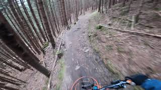
Rooty and rocky trail with some difficult spots from the Aufacker peak down through the forest towards Oberammergau, nothing extreme. Normally followed by Aufacker lower, which is slightly easier. Keep in mind that this is a popular hiking trail, in particular in the high season.
Access Info
Forest road starting from the parking lot of the Laber gondola in Oberammergau
This trail is unsanctioned.
More Stats for Aufacker Upper hike trail trail
-
Altitude change-610 ft
-
Altitude min4,381 ft
-
Altitude max4,991 ft
-
Altitude start4,991 ft
-
Altitude end4,380 ft
-
Grade-14.7%
-
Grade max-63.7%
-
Distance down4,091 ft
-
Distance flat66 ft
-
Avg time00:27:33
-
Avg reverse time00:39:01
- view trail stats
close
3D
Trail Conditions
- Unknown
- Snow Groomed
- Snow Packed
- Snow Covered
- Snow Cover Partial
- Freeze/thaw Cycle
- Icy
- Prevalent Mud
- Wet
- Variable
- Ideal
- Dry
- Very Dry
Trail Flow (Ridden Direction)
Trailforks scans users ridelogs to determine the most popular direction each trail is ridden. A good flowing trail network will have most trails flowing in a single direction according to their intension.
The colour categories are based on what percentage of riders are riding a trail in its intended direction.
- > 96%
- > 90%
- > 80%
- > 70%
- > 50%
- < 50%
- bi-directional trail
- no data
Trail Last Ridden
Trailforks scans ridelogs to determine the last time a trail was ridden.
- < 2 days
- < 1 week
- < 2 weeks
- < 1 month
- < 6 months
- > 6 months
Trail Ridden Direction
The intended direction a trail should be ridden.
- Downhill Only
- Downhill Primary
- Both Directions
- Uphill Primary
- Uphill Only
- One Direction
Contribute Details
Colors indicate trail is missing specified detail.
- Description
- Photos
- Description & Photos
- Videos
Trail Popularity ?
Trailforks scans ridelogs to determine which trails are ridden the most in the last 9 months.
Trails are compared with nearby trails in the same city region with a possible 25 colour shades.
Think of this as a heatmap, more rides = more kinetic energy = warmer colors.
- most popular
- popular
- less popular
- not popular
ATV/ORV/OHV Filter
Max Vehicle Width
inches
US Cell Coverage
Legend
Radar Time
x
Activity Recordings
Trailforks users anonymized public ridelogs from the past 6 months.
- mountain biking recent
- mountain biking (>6 month)
- hiking (1 year)
- moto (1 year)
Activity Recordings
Trailforks users anonymized public skilogs from the past 12 months.
- Downhill Ski
- Backcountry Ski
- Nordic Ski
- Snowmobile
Winter Trails
Warning
A routing network for winter maps does not exist. Selecting trails using the winter trails layer has been disabled.
x
Missing Trails
Most Popular
Least Popular
Trails are colored based on popularity. The more popular a trail is, the more red. Less popular trails trend towards green.
Jump Magnitude Heatmap
Heatmap of where riders jump on trails. Zoom in to see individual jumps, click circles to view jump details.
Trails Deemphasized
Trails are shown in grey.
Only show trails with NO bikes.
Save the current map location and zoom level as your default home location whenever this page is loaded.
Save
Directions to aufacker-upper trailhead
(47.613900, 11.097340)
update trails status or condition
Aufacker Upper Trail Reports
view all reports »
Recent Ridelog Activity on Trail
Past Week
- 0 rides
6 Months
- 1 rides
- 5 miles avg distance
All
- 2 rides
Photos
more »
We hope you've been enjoying Trailforks!
Create a FREE account to view trail comments and much more.
Nearby Trails
- Aufacker Three Marks 256 ft
- Aufacker Alt Upper 2,379 ft
- Aufacker Lower Trail 4,295 ft
- Aufacker Middle Access 1 mile
- Bei Den 3 Marken Access 2 miles
Ammergauer Alpen Area
- #246585 - 1,821 views
- follow/subscribe
- login to download gpx or kml files.
You must enter a description before submitting.