more stats
2.0 miles
Distance
67 ft
Climb
-1,720 ft
Descent
00:31:06
Avg time
-1,653 ft
Altitude change
2,778 ft
Altitude min
4,431 ft
Altitude max
4,431 ft
Altitude start
2,779 ft
Altitude end
-15.8%
Grade
-117%
Grade max
14.1%
Grade min
1,211 ft
Distance climb
2 miles
Distance down
505 ft
Distance flat
00:31:06
Avg time

B12 Details

  • Activities
    • Mountain Bike
    • E-Bike
  • Riding Area
    Mount 7
    Golden, British Columbia
  • Difficulty Rating
  • Voted Difficulty
    Black Diamond (5 votes)
  • Local Popularity
    25 in Mountain Biking [+]
    • 5 in E-Biking
  • Global Ranking
    #124299 in Mountain Biking [+]
    • #102127 in E-Biking
  • Trail Type
    Singletrack
  • Bike Type
    DH, AM
  • eBike Allowed

Warning, this trail has significant exposure and fall potential.

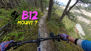
If you like old school trails with steep rutted fall lines, this trail is for you. Slippery when wet takes on a whole new meaning on this trail. Mix in some great Kicking Horse River canyon views and you have a superb loop ride from town, short enough to be an after work ride but long enough to feel complete.

Control your speed as you drop in; there are some trees that would like to knock you off your bike just before you get to a super tight switch back that always causes your heart to skip a beat no matter how often you ride this trail.

Fast and flowy with sections where you are controlling your speed so much that your forearms cramp along with your calves. Deep ruts add to the feeling of having your front tire locked in a rail like being in a carwash, not knowing if it is best to keep it there or get out. Towards the end of the trail just above the campground you come to a steep, slightly gnarly rooted section where the trail reaches a branch point. Continue straight to complete B12 and end at the Rotary Trails near the baseball diamonds, or alternatively go right at the branch point to take Kamikaze to the Municipal campground.

Access Info

Look for the B12 sign about 2km up the road from the 5K entrance sign.

Disclaimer

Warning: runs along Cliff sides; this trail has Significant exposure; Fall potential.

Local Trail Association
Traditionally Indigenous Territory

Recent Activity on Trail

Past Week
  • 0 rides
  •  
6 Months
  • 2 rides
  • 8 miles avg distance
All
  • 36 rides
  • Last: May 26, 2026
c1c2c3c4
January
February
March
April
May
June
July
August
September
October
November
December
update trails status or condition

B12 Trail Reports

statusdatedescription
May 5, 2026 @ 4:30pm (America/Edmonton)
May 5, 2026
reporter
Mar 30, 2026 @ 8:01pm (America/Edmonton)
Mar 30, 2026
reporter The trail crew will open trails as they are assessed. Thanks.
Jul 18, 2025 @ 2:31pm
Jul 18, 2025
Lots off steep descends.
Apr 30, 2025 @ 7:54am
Apr 30, 2025
reporter
Mar 12, 2025 @ 12:24pm
Mar 12, 2025
reporter Even though it feels like the start of the riding season the trails are still not good to go. Even the sunny slopes have sections with snow and...
more »
Status:
on May 5, 2026
Variable
Avg: 3.36 (15 votes)
Your vote: 0

view (231)
close
3D
Trail Conditions
  • Unknown
  • Snow Groomed
  • Snow Packed
  • Snow Covered
  • Snow Cover Partial
  • Freeze/thaw Cycle
  • Icy
  • Prevalent Mud
  • Wet
  • Variable
  • Ideal
  • Dry
  • Very Dry
Trail Flow (Ridden Direction)
Trailforks scans users ridelogs to determine the most popular direction each trail is ridden. A good flowing trail network will have most trails flowing in a single direction according to their intension.
The colour categories are based on what percentage of riders are riding a trail in its intended direction.
  • > 96%
  • > 90%
  • > 80%
  • > 70%
  • > 50%
  • < 50%
  • bi-directional trail
  • no data
Trail Last Ridden
Trailforks scans ridelogs to determine the last time a trail was ridden.
  • < 2 days
  • < 1 week
  • < 2 weeks
  • < 1 month
  • < 6 months
  • > 6 months
Trail Ridden Direction
The intended direction a trail should be ridden.
  • Downhill Only
  • Downhill Primary
  • Both Directions
  • Uphill Primary
  • Uphill Only
  • One Direction
Contribute Details
Colors indicate trail is missing specified detail.
  • Description
  • Photos
  • Description & Photos
  • Videos
Trail Popularity ?
Trailforks scans ridelogs to determine which trails are ridden the most in the last 9 months. Trails are compared with nearby trails in the same city region with a possible 25 colour shades. Think of this as a heatmap, more rides = more kinetic energy = warmer colors.
  • most popular
  • popular
  • less popular
  • not popular
ATV/ORV/OHV Filter
Max Vehicle Width
inches
US Cell Coverage
Legend
cell carrier legend

Radar Time
Activity Recordings
Trailforks uses anonymized public activity data. ?
Activity Recordings
Trailforks uses anonymized public activity data. ?
Personal Heatmap
Activity Types
all / none
Options
2
Date range month
Winter Trails
Warning A routing network for winter maps does not exist. Selecting trails using the winter trails layer has been disabled.
Missing Trails
Most Popular
Least Popular
Trails are colored based on popularity. The more popular a trail is, the more red. Less popular trails trend towards green.
Jump Magnitude Heatmap
Heatmap of where riders jump on trails. Zoom in to see individual jumps, click circles to view jump details.
BC Backroad Status

Service Road Atlas is a free to use, community-driven service for viewing and creating reports on the numerous back-country service roads around B.C. and Alberta.

map legend
Slope Aspect
Direction the slope faces
Flat N NE E SE S SW W NW
Trails Deemphasized
Trails are shown in grey.
disable
Only show trails with no bike usage.
Enable
Suggested Layers
Based on selected activity type

    Save the current map location and zoom level as your default home location whenever this page is loaded.

    Save
        Directions to b12 trailhead (51.290010, -116.910130)

        Photos

        13 more »
        236 |
        Nov 11, 2023 @ 1:55pm
        Nov 11, 2023
        362 |
        Oct 14, 2020 @ 10:06pm
        Oct 14, 2020
        530 |
        Jun 3, 2020 @ 8:28am
        Jun 3, 2020
        1,870 |
        Feb 29, 2004 @ 7:43pm
        Feb 29, 2004

        Videos

        2 more »
        B12 - Mount 7 (Sortie Kamikaze)
        19:07 | 190 | May 7, 2025 , Golden
        B12 crash
        0:16 | 1883 | May 14, 2012 , Golden

        4 Reviews & Comments


        We hope you've been enjoying Trailforks!

        Create a FREE account to view trail comments and much more.

        Nearby Trails

        • By canadakaTF Pro Trailforks & contributors
        • #3460 - 6,269 views

        Frequently Asked Questions About B12

        Where is B12 located?
        B12 is located in Mount 7, Golden, British Columbia, Canada. It is part of the Mount 7 trail network. The trailhead is located at coordinates 51.29001, -116.91013.
        How hard is B12?
        B12 is rated as Double Black Diamond difficulty. The average grade is 15.8%.
        What is the elevation gain for B12?
        B12 has 21 m of elevation gain. The trail has 524 m of elevation descent. The elevation ranges from 847 m to 1,351 m.
        How long is B12?
        B12 is 3.2 km long. The trail type is singletrack.

        Hit the Trail

        Open in App

        Get this trail on your phone instantly.
        open trail in app

        Download Trail

        Save to wishlist, Garmin & download.
        save the trail

        Find Related Routes

        Find routes and users activities that include this trail.
        find routes for this trail

        You must enter a description before submitting.