close
-
Layers w
- Weather Layers
- Pro
- Pro
- Pro
- Pro
- Pro
- Pro
- More Layers
- Pro
- Pro
- Pro
- Pro
-
Upgrade to

3D
Trail Conditions
- Unknown
- Snow Groomed
- Snow Packed
- Snow Covered
- Snow Cover Partial
- Freeze/thaw Cycle
- Icy
- Prevalent Mud
- Wet
- Variable
- Ideal
- Dry
- Very Dry
Trail Flow (Ridden Direction)
Trailforks scans users ridelogs to determine the most popular direction each trail is ridden. A good flowing trail network will have most trails flowing in a single direction according to their intension.
The colour categories are based on what percentage of riders are riding a trail in its intended direction.
The colour categories are based on what percentage of riders are riding a trail in its intended direction.
- > 96%
- > 90%
- > 80%
- > 70%
- > 50%
- < 50%
- bi-directional trail
- no data
Trail Last Ridden
Trailforks scans ridelogs to determine the last time a trail was ridden.
- < 2 days
- < 1 week
- < 2 weeks
- < 1 month
- < 6 months
- > 6 months
Trail Ridden Direction
The intended direction a trail should be ridden.
- Downhill Only
- Downhill Primary
- Both Directions
- Uphill Primary
- Uphill Only
- One Direction
Contribute Details
Colors indicate trail is missing specified detail.
- Description
- Photos
- Description & Photos
- Videos
Trail Popularity ?
Trailforks scans ridelogs to determine which trails are ridden the most in the last 9 months.
Trails are compared with nearby trails in the same city region with a possible 25 colour shades.
Think of this as a heatmap, more rides = more kinetic energy = warmer colors.
- most popular
- popular
- less popular
- not popular
ATV/ORV/OHV Filter
Max Vehicle Width
inches
US Cell Coverage
Legend

Radar Time
Activity Recordings
Trailforks uses anonymized public activity data.
?
Activity Recordings
Trailforks uses anonymized public activity data.
?
Personal Heatmap
▶
Activity Types
all
/
none
▶
Options
2
Date range
month
–
Winter Trails
Warning
A routing network for winter maps does not exist. Selecting trails using the winter trails layer has been disabled.
Missing Trails
Most Popular
Least Popular
Trails are colored based on popularity. The more popular a trail is, the more red. Less popular trails trend towards green.
Jump Magnitude Heatmap
Heatmap of where riders jump on trails. Zoom in to see individual jumps, click circles to view jump details.
BC Backroad Status
![map legend]()
Service Road Atlas is a free to use, community-driven service for viewing and creating reports on the numerous back-country service roads around B.C. and Alberta.

Slope Aspect
Direction the slope faces
Trails Deemphasized
Trails are shown in grey.
Only show trails with no bike usage.
Suggested Layers
Based on selected activity type
Save the current map location and zoom level as your default home location whenever this page is loaded.
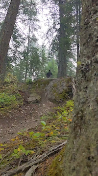
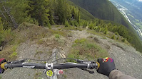
SaveGolden’s hotspot for downhill shuttle laps can be found on Mount 7, the prominent peak just east of town. Named for the ephemeral 7 that appears high on the ridgeline each spring, this trail network has been the heart of local downhill riding for many years.
Mount 7 was once home to the infamous Psychosis Race where World Cup racers would come to pit themselves against the mountain. Some succeeded, but many failed. The Psychosis Race is long gone, but you can still challenge the mountain.
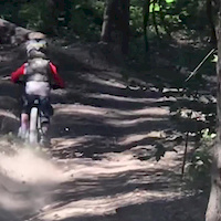
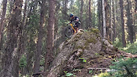
Over the years, the mainly old-school style trails have taken on a rougher and more rugged appearance. It’s character can be summarized as steep It’s no bike park, just pure, proper downhill riding.
Hunt about, or ask the locals, and you’ll find some hidden gems tucked away: wood features, gap jumps, cliff drops, and double blacks to challenge the most seasoned rider. Many of these trails were originally built underground, so best to scout them first.
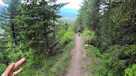
Some new XC trails are starting to be developed on Mount 7. Namely the bidirectional XC trail Schacher, which now climbs right up to the Launch site at the top.
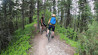
When shuttling Mount 7, please use 4-Wheel-Drive vehicles. High clearance is recommended. Drive responsibly and put vehicles in 4x4 to keep the road in the best shape possible! Thanks in advance.
With gratitude, the Golden Cycling Club would like to acknowledge that the trails we recreate on are on the homelands of the Ktunaxa and Secwepemc people and the chosen home of the Metis Nation Columbia River Society.
Mount 7 was once home to the infamous Psychosis Race where World Cup racers would come to pit themselves against the mountain. Some succeeded, but many failed. The Psychosis Race is long gone, but you can still challenge the mountain.
Over the years, the mainly old-school style trails have taken on a rougher and more rugged appearance. It’s character can be summarized as steep It’s no bike park, just pure, proper downhill riding.
Hunt about, or ask the locals, and you’ll find some hidden gems tucked away: wood features, gap jumps, cliff drops, and double blacks to challenge the most seasoned rider. Many of these trails were originally built underground, so best to scout them first.
Some new XC trails are starting to be developed on Mount 7. Namely the bidirectional XC trail Schacher, which now climbs right up to the Launch site at the top.
When shuttling Mount 7, please use 4-Wheel-Drive vehicles. High clearance is recommended. Drive responsibly and put vehicles in 4x4 to keep the road in the best shape possible! Thanks in advance.
With gratitude, the Golden Cycling Club would like to acknowledge that the trails we recreate on are on the homelands of the Ktunaxa and Secwepemc people and the chosen home of the Metis Nation Columbia River Society.
Primary Trail Type: All-Mountain & Downhill
Shuttleable: YES
 google parking directions
 Access Info:
The staging area for shuttling Mount 7 is at the Reflection Lake Trailhead parking area; complete with washrooms and an info kiosk. All Mount 7 trails return to this point. It is also the parking area for the Mtn Shadows XC network, so you can mix it up or split up if you have a diverse group.
The Reflection Lake Trailhead parking area can be reached by biking or driving 1km south of town on Hwy 95, then turning left onto Reflection Lake Rd. The Reflection Lake Trailhead parking area is down another 0.4km on your right.
From this parking area trails are accessed via the Bowle-Evans Forest Service Rd, a 14km long dirt road leading to the top of the trail network. Along the way there are also parking areas at 3km, 5km,and 10km for multiple trail options. This is a multi-use road shared by hang gliders, paragliders, hikers, sightseers and also bikers who wish to earn their downhills, so drive with care and consideration.
The road does get graded about once a year, but it can still be rough in places and dusty in the summer. During the spring melt, the road can take until the beginning of June to fully dry out. Expect the road to be gated at the 10km mark if you come early season.
Activities Click to view
- Mountain Bike
17 trails
- E-Bike
16 trails
- Hike
5 trails
- Trail Running
6 trails
Region Details
- 2
- 1
- 5
- 6
- 3
Region Status
Open as of Jun 29, 2026Local Trail Association
Stats
- Avg Trail Rating
- Trails (view details)
- 17
- Trails Mountain Bike
- 17
- Trails E-Bike
- 16
- Trails Horse
- 1
- Trails Hike
- 5
- Trails Trail Running
- 6
- Trails Dirtbike/Moto
- 2
- Trails ATV/ORV/OHV
- 1
- Total Distance
- 21 miles
- Total Descent Distance
- 12 miles
- Total Descent
- 10,486 ft
- Total Vertical
- 3,749 ft
- Highest Trailhead
- 6,362 ft
- Reports
- 813
- Photos
- 197
- Ridden Counter
- 14,303
Articles
Essay: Gravitational Push - Overcoming Loss Through a Grueling Solo Mission
Mar 25, 2022 from pinkbike.com
Writer Matt Coté grapples with earth's most powerful force on British Columbia's Mount 7.
Video: Downhill Young Guns Tackle on the Legendary Psychosis Course
Aug 6, 2020 from pinkbike.com
Your GoPro effect has no power here.
Popular Mount 7 Mountain Biking Trails
• 95 ★ 4.4 • 2,133 ft • 0 ft • 1,836 •
This trail is a great finisher that gets you to Reflection Lake Road. It was the end portion of the old Psychosis DH race. If you are coming from the , 5K, or 3K then you will end up on this trail. As you enter onto Tail Gate/Snake Hill...
• 100 ★ 4.3 • 2,395 ft • 0 ft • 1,737 •
This trail is often shuttled, but depending on the bike you are riding, can easily be done as a circuit (pedalling up the road, and down the trail). Before you start, have a quick listen and look up trail for any riders that may be...
• 85 ★ 4.4 • 1 mile • 76 ft • 1,094 •
5K is a classic section of trail on the lower part of the main Mount 7 descent trail. The 5K trail starts out with a short, challenging, rooty climb to the main trail. Mere mortals will give up and walk this section, how about you? When...
• 80 ★ 4.5 • 9 miles • 4,364 ft • 869 •
provides the first “up” singletrack for Mt 7. It was built with cross country riders in mind. Put it in low gear and enjoy the climb. Scope the berms, bridges and jumps as you wind up through tall timber. You’ll be hammering these...
• 90 ★ 1.7 • 1 mile • 407 ft • 765 •
can be used in combination with 7 Up and Bush Party as an alternate to pedalling up the Bowle-Evans Road. It is a combination of skidder road and double track, which most riders find preferable to the road. It is more enjoyable to ride...
• 80 ★ 4.2 • 1,627 ft • 12 ft • 692 •
For those looking to ride 5K trail and earn their turns, ride up and then branch off onto to reach the entrance of 5K. is a short blast for cross country riders. You’ll find some berms and some smaller jumps. This trail is single...
• 85 ★ 3.4 • 486 ft • 20 ft • 671 •
Popular blue difficulty singletrack. This mountain bike primary trail can be used downhill only. On average it takes 1 minutes to complete this trail.
• 15 ★ 3.6 • 157 ft • 7 ft • 633 •
Less popular blue difficulty singletrack. This mountain bike primary trail can be used downhill only. On average it takes 1 minutes to complete this trail.
Mount 7 Mountain Bike Routes
9 miles • 1,695 ft • 8 • Race •
Join us September 20, 2025 for a fun, inclusive, ladies enduro! Everyone is welcome. Only 100 spots...
• 17 miles • 4,932 ft • 10 •
• 24 miles • 6,728 ft • 12 •
• 21 miles • 4,628 ft • 23 •
Photos of Mount 7 Mountain Bike
Videos of Mount 7 Mountain Bike
trail: Schacher
0:11 |
277 |
Oct 14, 2022
trail: Summit
0:08 |
194 |
Jul 22, 2022
trail: 5K
0:07 |
264 |
Nov 1, 2021
trail: Skid Marks
0:53 |
152 |
Aug 25, 2020
trail: 5K
0:43 |
176 |
Jul 3, 2020
trail: 5K
0:57 |
126 |
Jul 3, 2020
trail: Dead Dog
2:33 |
728 |
Jun 7, 2020
trail: Schacher
0:08 |
1596 |
Oct 5, 2018
Recent Trail Reports
| status | trail | date | condition | info | user |
|---|---|---|---|---|---|
| 5 Km Alt | Jun 29, 2026 @ 10:44am (America/Creston) Jun 29, 2026 | Dry | canadaka Trailforks | ||
| 5K | Jun 29, 2026 @ 10:44am (America/Creston) Jun 29, 2026 | Ideal | canadaka Trailforks | ||
| 6k | Jun 29, 2026 @ 10:44am (America/Creston) Jun 29, 2026 | Ideal | canadaka Trailforks | ||
| Bris | Jun 29, 2026 @ 9:08pm (America/Edmonton) Jun 29, 2026 | Ideal | canadaka Trailforks | ||
| Moonshine | Jun 29, 2026 @ 9:07pm (America/Edmonton) Jun 29, 2026 | Ideal | canadaka Trailforks | ||
| Tail Gate Alt | Jun 26, 2026 @ 2:23pm (America/Creston) Jun 26, 2026 | Ideal | canadaka Trailforks | ||
| Skid Marks | Jun 26, 2026 @ 2:23pm (America/Creston) Jun 26, 2026 | Variable | canadaka Trailforks | ||
| Woodlot Ride | Jun 26, 2026 @ 2:23pm (America/Creston) Jun 26, 2026 | Variable | canadaka Trailforks | ||
| GnR | Jun 26, 2026 @ 2:23pm (America/Creston) Jun 26, 2026 | Ideal | canadaka Trailforks | ||
| Snake Hill/Tail Gate | Jun 26, 2026 @ 2:23pm (America/Creston) Jun 26, 2026 | Ideal | canadaka Trailforks |
Activity Feed
| username | action | type | title | date |
|---|---|---|---|---|
| josuno | ridden | trail | activity #98547830 | Jul 5, 2026 @ 5:34pm 19 hours |
| Ethanbkkersss | ridden | trail | activity #98458799 | Jul 4, 2026 @ 4:04pm 2 days |
| canadaka | add | report | activity #98141744 and 2 more | Jun 30, 2026 @ 10:40am Jun 30, 2026 |
| canadaka | add | report | activity #98105270 and 1 more | Jun 29, 2026 @ 8:07pm Jun 29, 2026 |
| CamBetts0791 | wishlist | trail | activity #98042747 | Jun 28, 2026 @ 8:31pm Jun 28, 2026 |
Recent Comments
| username | type | title | comment | date |
|---|---|---|---|---|
| trail | this is some next level shit | Mar 14, 2026 @ 8:28pm Mar 14, 2026 | ||
| trail | This trail is defenitely a Double Black! I... | Sep 16, 2025 @ 9:59pm Sep 16, 2025 | ||
| trail | This trail is defenitely a double black. I... | Sep 16, 2025 @ 5:39pm Sep 16, 2025 | ||
| trail | This is a great trail ... the steep that is... | Jul 13, 2025 @ 11:10pm Jul 13, 2025 | ||
| trail | Wow fun | Jun 24, 2025 @ 6:09pm Jun 24, 2025 |
Nearby Areas
| name | distance | ||||
|---|---|---|---|---|---|
| Mountain Shadows | 2 | 16 | 2 | 1 km | |
| Mt. 7 North Ridge Recreation Site | 1 | 1.7 km | |||
| Canyon Ridge Trails | 15 | 2.5 km | |||
| Moonrakers | 1 | 21 | 2 | 3.1 km | |
| CBT Mainline Network | 1 | 18 | 3.3 km |
Local Badges
-

Completionist0 awarded
Local Mountain Biking Directory
-
Starr Trail Solutions
-
Higher Ground Sports
![Higher Ground Sports]()
-
Higher Ground Mountain Sports
-
Selkirk Ski and Bike
![Selkirk Ski and Bike]()
-
Golden Cycling ClubTrail Association
![Golden Cycling Club]()
-
Derailed SportsBike Shop
![Derailed Sports]()
Local Trail Supporters
![]()
![Ethos Cafe]()
- James Acton & Chantalle Schacher
Activity Type Stats
| activitytype | trails | distance | descent | descent distance | total vertical | rating | global rank | state rank | photos | reports | routes | ridelogs |
|---|---|---|---|---|---|---|---|---|---|---|---|---|
| Mountain Bike | 17 | 21 miles | 10,486 ft | 12 miles | 3,750 ft | #1,858 | #119 | 189 | 813 | 3 | 8,429 | |
| E-Bike | 16 | 21 miles | 9,934 ft | 12 miles | 3,750 ft | #3,524 | #128 | 536 | 2 | 297 | ||
| Horse | 1 | 1 mile | 367 ft | 397 ft | 226 | |||||||
| Hike | 5 | 14 miles | 3,041 ft | 5 miles | 3,583 ft | #7,998 | #316 | 737 | 167 | |||
| Trail Running | 6 | 14 miles | 3,143 ft | 5 miles | 3,583 ft | #6,968 | 1 | 744 | 205 | |||
| Dirtbike/Moto | 2 | 1 mile | 7 ft | 515 ft | 2,825 ft | 4 | 235 | 5 | ||||
| ATV/ORV/OHV | 1 | 1 mile | 367 ft | 397 ft | 233 | 1 |
Frequently Asked Questions About Mount 7
▼
What are the highest rated mountain biking trails in Mount 7?
The highest rated mountain biking trails in Mount 7 are:
- Dead Dog (4.4/5)
- Skid Marks (4.4/5)
- Schacher (4.4/5)
- 5K (4.3/5)
- Moonshine (4.3/5)
▼
What is the best time of the year to ride in Mount 7?
Based on ride log data, the most popular months to ride in Mount 7 are:
- July (170 activities)
- August (91 activities)
- June (76 activities)
▼
Where can I park to ride in Mount 7?
There are 1 parking locations listed in Mount 7. The most popular parking spots are:
▼
What is the longest trail in Mount 7?
The longest trail in Mount 7 is Schacher at 13.9 km. View all trails sorted by distance.
Activities
Trails
Points of Interest
- By brenthillier
 NSMBA TRAILFORKS & contributors
 - Admins: GCC, GCC2, GORMA, kcytko, cgennings, GCC D2
- #3326 - 37,977 views
- mount 7 activity log | embed map of Mount 7 mountain bike trails | mount 7 mountain biking points of interest
Downloading of trail gps tracks in kml & gpx formats is enabled for Mount 7.
You must login to download files.