1.2 miles
Distance
-628 ft
Descent
00:07:09
Avg time
Back In Black Details
-
Activities
- Mountain Bike
-
Riding AreaMount Washington Bike Park
Courtenay, British Columbia -
Difficulty Rating
-
Voted DifficultyBlack Diamond (4 votes)
-
Trail TypeSingletrack
-
Bike TypeDH
-
DirectionDownhill OnlyPopular direction shown
-
Physical RatingHard
-
Trail VisibilityAlways easy to follow
-
eBike AllowedYes up to Class 1
-
TTFs on TrailBerm, Bridge, Drop, Jump, Ladder Bridge, Rock Garden, Wallride
-
Global Ranking#4183 in Mountain Biking
-
Local Popularity95 in Mountain Biking
-
Land Owner
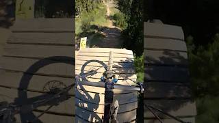
Slalom style trail, doubles and drops. Not as hard as it once was due to gaps being filled with wood or dirt to decrease the consequences, but still the most difficult trail on Mt Washington. The second drop is the largest (roughly 8 feet).
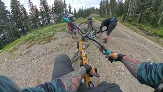
Once you hit trail speed, it's smooth as butter, corners usually hold up well over the season, and less Jerry's than on the other trails. Small tech section at the bottom. Definitely the best trail on the hill.
Traditionally Indigenous Territory
More Stats for Back In Black mountain bike trail trail
-
Altitude change-628 ft
-
Altitude min3,646 ft
-
Altitude max4,274 ft
-
Altitude start4,274 ft
-
Altitude end3,645 ft
-
Grade-10.3%
-
Grade max-35.9%
-
Grade min1.8%
-
Distance climb10 ft
-
Distance down1 mile
-
Distance flat164 ft
-
Avg time00:07:09
-
Avg reverse time01:01:41
- view trail stats
close
3D
Trail Conditions
- Unknown
- Snow Groomed
- Snow Packed
- Snow Covered
- Snow Cover Inadequate
- Freeze/thaw Cycle
- Icy
- Prevalent Mud
- Wet
- Variable
- Ideal
- Dry
- Very Dry
Trail Flow (Ridden Direction)
Trailforks scans users ridelogs to determine the most popular direction each trail is ridden. A good flowing trail network will have most trails flowing in a single direction according to their intension.
The colour categories are based on what percentage of riders are riding a trail in its intended direction.
- > 96%
- > 90%
- > 80%
- > 70%
- > 50%
- < 50%
- bi-directional trail
- no data
Trail Last Ridden
Trailforks scans ridelogs to determine the last time a trail was ridden.
- < 2 days
- < 1 week
- < 2 weeks
- < 1 month
- < 6 months
- > 6 months
Trail Ridden Direction
The intended direction a trail should be ridden.
- Downhill Only
- Downhill Primary
- Both Directions
- Uphill Primary
- Uphill Only
- One Direction
Contribute Details
Colors indicate trail is missing specified detail.
- Description
- Photos
- Description & Photos
- Videos
Trail Popularity ?
Trailforks scans ridelogs to determine which trails are ridden the most in the last 9 months.
Trails are compared with nearby trails in the same city region with a possible 25 colour shades.
Think of this as a heatmap, more rides = more kinetic energy = warmer colors.
- most popular
- popular
- less popular
- not popular
ATV/ORV/OHV Filter
Max Vehicle Width
inches
Radar Time
x
Activity Recordings
Trailforks users anonymized public ridelogs from the past 6 months.
- mountain biking recent
- mountain biking (>6 month)
- hiking (1 year)
- moto (1 year)
Activity Recordings
Trailforks users anonymized public skilogs from the past 12 months.
- Downhill Ski
- Backcountry Ski
- Nordic Ski
- Snowmobile
Winter Trails
Warning
A routing network for winter maps does not exist. Selecting trails using the winter trails layer has been disabled.
x
Missing Trails
Most Popular
Least Popular
Trails are colored based on popularity. The more popular a trail is, the more red. Less popular trails trend towards green.
Jump Magnitude Heatmap
Heatmap of where riders jump on trails. Zoom in to see individual jumps, click circles to view jump details.
Trails Deemphasized
Trails are shown in grey.
Only show trails with NO bikes.
Save the current map location and zoom level as your default home location whenever this page is loaded.
Save
Directions to back-black trailhead
(49.750630, -125.305510)
update trails status or condition
Back In Black Trail Reports
view all reports »
Recent Ridelog Activity on Trail
Past Week
- 13 rides
- 24 miles avg distance
6 Months
- 389 rides
- 23 miles avg distance
All
- 2,405 rides
- Last: Sep 17, 2023
Photos
more »
Routes with this trail
Trail Products
3 Reviews & Comments
We hope you've been enjoying Trailforks!
Create a FREE account to view trail comments and much more.
Videos
more »
youtuber

11:02 |
702 |
Nov 5, 2020 , Courtenay
Nearby Trails
- Blue Hammer 0 ft
- Helter Skelter 217 ft
- Mid-mountain Connector 528 ft
- Jacks 587 ft
- Lower Westerley 968 ft
Mount Washington Bike Park
- By Tekmisfit & contributors
- #2432 - 6,151 views
- subscribe
- login to download gpx or kml files.