more stats
3,442 ft
Distance
-482 ft
Descent
00:03:01
Avg time
-482 ft
Altitude change
3,638 ft
Altitude min
4,120 ft
Altitude max
4,120 ft
Altitude start
3,638 ft
Altitude end
-14%
Grade
-34.8%
Grade max
-6.1%
Grade min
3,412 ft
Distance down
00:03:01
Avg time

Ball-N-Jack Details

  • Activities
    • Mountain Bike
  • Riding Area
    Snowshoe Bike Park
    Snowshoe Village, West Virginia
  • Difficulty Rating
  • Local Popularity
    85 in Mountain Biking
  • Global Ranking
    #47072 in Mountain Biking
  • Trail Type
    Singletrack
  • Bike Type
    DH, AM
  • Direction
    Downhill Only
    Popular Direction Shown
  • Physical Rating
    Moderate
  • Dogs Allowed
    Yes
  • TTFs on Trail
    Berm, Drop, Jump

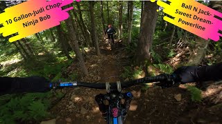
Ball n Jack begins with a series of tabletop jumps followed by several berm turns. The berms start off big and wide and then turn tighter and steeper before the trail straightens out at the bottom for a fast finish. A notable feature in the middle of the berm section is a 4-5 foot rock drop/jump which will put a huge smile on your face, but if you’re not ready for the airtime it can easily be avoided on the left side of the trail.
***The bottom of the trail has recently been rerouted. It has some rollers and optional jump features. It now ends with a split at the Big Ash Powerline intersection with a tight berm.

Bike Park

Local Trail Association
Traditionally Indigenous Territory

Recent Activity on Trail

Past Week
  • 12 rides
  • 24 miles average
6 Months
  • 56 rides
  • 26 miles avg distance
All
  • 664 rides
  • Last: Jul 3, 2026
c1c2c3c4
January
February
March
April
May
June
July
August
September
October
November
December
Status:
on Jun 20, 2026
Variable
Avg: 4.05 (13 votes)
Your vote: 0

view (6,311)
close
3D
Trail Conditions
  • Unknown
  • Snow Groomed
  • Snow Packed
  • Snow Covered
  • Snow Cover Partial
  • Freeze/thaw Cycle
  • Icy
  • Prevalent Mud
  • Wet
  • Variable
  • Ideal
  • Dry
  • Very Dry
Trail Flow (Ridden Direction)
Trailforks scans users ridelogs to determine the most popular direction each trail is ridden. A good flowing trail network will have most trails flowing in a single direction according to their intension.
The colour categories are based on what percentage of riders are riding a trail in its intended direction.
  • > 96%
  • > 90%
  • > 80%
  • > 70%
  • > 50%
  • < 50%
  • bi-directional trail
  • no data
Trail Last Ridden
Trailforks scans ridelogs to determine the last time a trail was ridden.
  • < 2 days
  • < 1 week
  • < 2 weeks
  • < 1 month
  • < 6 months
  • > 6 months
Trail Ridden Direction
The intended direction a trail should be ridden.
  • Downhill Only
  • Downhill Primary
  • Both Directions
  • Uphill Primary
  • Uphill Only
  • One Direction
Contribute Details
Colors indicate trail is missing specified detail.
  • Description
  • Photos
  • Description & Photos
  • Videos
Trail Popularity ?
Trailforks scans ridelogs to determine which trails are ridden the most in the last 9 months. Trails are compared with nearby trails in the same city region with a possible 25 colour shades. Think of this as a heatmap, more rides = more kinetic energy = warmer colors.
  • most popular
  • popular
  • less popular
  • not popular
ATV/ORV/OHV Filter
Max Vehicle Width
inches
US Cell Coverage
Legend
cell carrier legend

Radar Time
Activity Recordings
Trailforks uses anonymized public activity data. ?
Activity Recordings
Trailforks uses anonymized public activity data. ?
Personal Heatmap
Activity Types
all / none
Options
2
Date range month
Winter Trails
Warning A routing network for winter maps does not exist. Selecting trails using the winter trails layer has been disabled.
Missing Trails
Most Popular
Least Popular
Trails are colored based on popularity. The more popular a trail is, the more red. Less popular trails trend towards green.
Jump Magnitude Heatmap
Heatmap of where riders jump on trails. Zoom in to see individual jumps, click circles to view jump details.
BC Backroad Status

Service Road Atlas is a free to use, community-driven service for viewing and creating reports on the numerous back-country service roads around B.C. and Alberta.

map legend
Slope Aspect
Direction the slope faces
Flat N NE E SE S SW W NW
Trails Deemphasized
Trails are shown in grey.
disable
Only show trails with no bike usage.
Enable
Suggested Layers
Based on selected activity type

    Save the current map location and zoom level as your default home location whenever this page is loaded.

    Save
        Directions to ballnjack trailhead (38.423070, -80.003060)

        Photos

        6 more »
        891 |
        Aug 17, 2015 @ 1:39pm
        Aug 17, 2015
        476 |
        Jun 27, 2015 @ 2:14pm
        Jun 27, 2015
        521 |
        Jun 27, 2015 @ 2:14pm
        Jun 27, 2015
        391 |
        Jun 27, 2015 @ 2:14pm
        Jun 27, 2015

        Videos

        5 more »
        Snowshoe Bike Park Closing Day Final Run,...
        23:44 | 120 | Sep 15, 2023 , Snowshoe Village
        Ball N Jack
        17:01 | 187 | Sep 22, 2022 , Snowshoe Village
        10 Gallon/Judi Chop/Ninja Bob/Ball N...
        5:06 | 254 | Sep 27, 2020 , Snowshoe Village
        Friendly reminder to check your thru axle
        0:09 | 129 | Sep 25, 2022 , Snowshoe Village

        Routes with this trail

        23 miles 3,571 ft 16 Loop Race
        Stage 1- Access to next Stage- Ballhooter Lift, to top of M Stage 2- M & O Access to next Stage- Pedal to...
        2 miles 6 ft 5 Point to Point Race
        Course #2 for the Chomolungma Challenge

        2 Reviews & Comments


        We hope you've been enjoying Trailforks!

        Create a FREE account to view trail comments and much more.

        Frequently Asked Questions About Ball-N-Jack

        Where is Ball-N-Jack located?
        Ball-N-Jack is located in Snowshoe Bike Park, Snowshoe Village, West Virginia, United States. It is part of the Snowshoe Bike Park trail network. The trailhead is located at coordinates 38.42307, -80.00306.
        How hard is Ball-N-Jack?
        Ball-N-Jack is rated as Blue difficulty. The physical rating is Moderate. The average grade is 14%.
        What is the elevation gain for Ball-N-Jack?
        The trail has 482 ft of elevation descent. The elevation ranges from 3,638 ft to 4,120 ft.
        Is Ball-N-Jack a point to point trail?
        Yes, Ball-N-Jack is a point to point trail. The direction is Downhill Only. The trail type is singletrack.

        Hit the Trail

        Open in App

        Get this trail on your phone instantly.
        open trail in app

        Download Trail

        Save to wishlist, Garmin & download.
        save the trail

        Find Related Routes

        Find routes and users activities that include this trail.
        find routes for this trail

        You must enter a description before submitting.