more stats
1.8 miles
Distance
3 ft
Climb
-1,772 ft
Descent
00:23:08
Avg time
-1,769 ft
Altitude change
2,650 ft
Altitude min
4,419 ft
Altitude max
4,419 ft
Altitude start
2,651 ft
Altitude end
-18.4%
Grade
-61.2%
Grade max
2.3%
Grade min
223 ft
Distance climb
2 miles
Distance down
46 ft
Distance flat
00:23:08
Avg time

Baloo Details

  • Activities
    • Mountain Bike
  • Riding Area
    Straja Resort
    Lupeni
  • Difficulty Rating
  • Voted Difficulty
    Blue (3 votes)
  • Local Popularity
    100 in Mountain Biking
  • Global Ranking
    #44122 in Mountain Biking
  • Trail Type
    Singletrack
  • Bike Type
    DH, AM
  • Direction
    Downhill Only
    Popular Direction Shown
  • Physical Rating
    Moderate
  • Trail Visibility
    Always easy to follow
  • Season
    Mar - Nov
  • Dogs Allowed
    Yes
  • TTFs on Trail
    Berm, Jump
  • Ride in Rain
    Yes
  • Year Opened
    2017

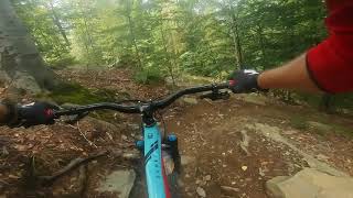
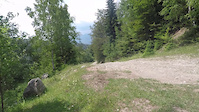
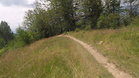
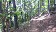
The second trail built at Straja Resort. It's a flow-trail, entirely man-built, with berms in almost every corner. Smooth and fast, but lacks jumps.

Access Info

After you exit the gondola, turn right, climb to the main road, go down about 50m and turn left on a dirt road. There's a sign there.

Bike Park

Recent Activity on Trail

Past Week
  • 0 rides
  •  
6 Months
  • 0 rides
  •  
All
  • 76 rides
  • Last: Jul 19, 2025
c1c2c3c4
January
February
March
April
May
June
July
August
September
October
November
December
update trails status or condition

Baloo Trail Reports

statusdatedescription
Jul 4, 2026 @ 8:24pm (Europe/Bucharest)
1 day
Trail is closed untill the 12th of July 2026 due to trail maintenence and update. More info at Straja Extreme Bikepark. They will help you with...
Sep 27, 2022 @ 7:53am
Sep 27, 2022
There's a ditch being dug on the trail, for around 100m. It looked fresh, so I think they'll finish soon. You can easily go around it, on the ski...
Jul 19, 2021 @ 3:11am
Jul 19, 2021
The new additions (double, bridges etc) are awesome. Trail in good condition only a bit dry.
Jul 8, 2021 @ 10:51pm
Jul 8, 2021
Trail was in very good condition when the gondola was open for summer 2 weeks ago. Additional rolls, tabletops, 2 new bridges that can be jumped...
Aug 2, 2020 @ 6:50am
Aug 2, 2020
Medium to advanced skills are necessary. It is declared as RED color on the trail map find at the trail entrance.
more »
Status:
on Jul 4, 2026
Avg: 4.19 (6 votes)
Your vote: 0

view (421)
close
3D
Trail Conditions
  • Unknown
  • Snow Groomed
  • Snow Packed
  • Snow Covered
  • Snow Cover Partial
  • Freeze/thaw Cycle
  • Icy
  • Prevalent Mud
  • Wet
  • Variable
  • Ideal
  • Dry
  • Very Dry
Trail Flow (Ridden Direction)
Trailforks scans users ridelogs to determine the most popular direction each trail is ridden. A good flowing trail network will have most trails flowing in a single direction according to their intension.
The colour categories are based on what percentage of riders are riding a trail in its intended direction.
  • > 96%
  • > 90%
  • > 80%
  • > 70%
  • > 50%
  • < 50%
  • bi-directional trail
  • no data
Trail Last Ridden
Trailforks scans ridelogs to determine the last time a trail was ridden.
  • < 2 days
  • < 1 week
  • < 2 weeks
  • < 1 month
  • < 6 months
  • > 6 months
Trail Ridden Direction
The intended direction a trail should be ridden.
  • Downhill Only
  • Downhill Primary
  • Both Directions
  • Uphill Primary
  • Uphill Only
  • One Direction
Contribute Details
Colors indicate trail is missing specified detail.
  • Description
  • Photos
  • Description & Photos
  • Videos
Trail Popularity ?
Trailforks scans ridelogs to determine which trails are ridden the most in the last 9 months. Trails are compared with nearby trails in the same city region with a possible 25 colour shades. Think of this as a heatmap, more rides = more kinetic energy = warmer colors.
  • most popular
  • popular
  • less popular
  • not popular
ATV/ORV/OHV Filter
Max Vehicle Width
inches
US Cell Coverage
Legend
cell carrier legend

Radar Time
Activity Recordings
Trailforks uses anonymized public activity data. ?
Activity Recordings
Trailforks uses anonymized public activity data. ?
Personal Heatmap
Activity Types
all / none
Options
2
Date range month
Winter Trails
Warning A routing network for winter maps does not exist. Selecting trails using the winter trails layer has been disabled.
Missing Trails
Most Popular
Least Popular
Trails are colored based on popularity. The more popular a trail is, the more red. Less popular trails trend towards green.
Jump Magnitude Heatmap
Heatmap of where riders jump on trails. Zoom in to see individual jumps, click circles to view jump details.
BC Backroad Status

Service Road Atlas is a free to use, community-driven service for viewing and creating reports on the numerous back-country service roads around B.C. and Alberta.

map legend
Slope Aspect
Direction the slope faces
Flat N NE E SE S SW W NW
Trails Deemphasized
Trails are shown in grey.
disable
Only show trails with no bike usage.
Enable
Suggested Layers
Based on selected activity type

    Save the current map location and zoom level as your default home location whenever this page is loaded.

    Save
        Directions to baloo trailhead (45.321368, 23.235226)

        Photos

        6 more »
        194 |
        Mar 5, 2020 @ 3:24am
        Mar 5, 2020
        203 |
        Oct 18, 2018 @ 2:45pm
        Oct 18, 2018
        223 |
        Oct 18, 2018 @ 2:47pm
        Oct 18, 2018
        222 |
        Oct 18, 2018 @ 2:49pm
        Oct 18, 2018

        Videos

        5 more »
        Muntii Valcan,Straja,Baloo
        9:38 | 744 | Feb 3, 2020 , Lupeni
        Baloo 04 2021 - last part
        2:34 | 30 | Jul 12, 2021 , Lupeni
        Baloo 03 2021 - third part
        3:57 | 13 | Jul 12, 2021 , Lupeni
        Baloo 02 2021 - second part
        4:29 | 15 | Jul 12, 2021 , Lupeni

        Routes with this trail

        12 miles 3,255 ft 10 Point to Point Race
        The race course for National Romanian Enduro Championship in 2019

        Reviews / Comments

        No reviews yet, be the first to write a review or ask a question.
        Use trail reports to comment on trail conditions.


        We hope you've been enjoying Trailforks!

        Create a FREE account to view trail comments and much more.

        • By pufalotTF Pro TRAILFORKS & contributors
        • #101835 - 2,272 views

        Frequently Asked Questions About Baloo

        Where is Baloo located?
        Baloo is located in Straja Resort, Lupeni, Romania. It is part of the Straja Resort trail network. The trailhead is located at coordinates 45.32137, 23.23523.
        How hard is Baloo?
        Baloo is rated as Blue difficulty. The physical rating is Moderate. The average grade is 18.4%.
        What is the elevation gain for Baloo?
        Baloo has 1 m of elevation gain. The trail has 540 m of elevation descent. The elevation ranges from 808 m to 1,347 m.
        Is Baloo a point to point trail?
        Yes, Baloo is a point to point trail. The direction is Downhill Only. The trail type is singletrack.

        Hit the Trail

        Open in App

        Get this trail on your phone instantly.
        open trail in app

        Download Trail

        Save to wishlist, Garmin & download.
        save the trail

        Find Related Routes

        Find routes and users activities that include this trail.
        find routes for this trail

        You must enter a description before submitting.