3,839 ft
Distance
2 ft
Climb
-390 ft
Descent
00:07:09
Avg time

Bear Buns Details

  • Activities
    • Mountain Bike
    • E-Bike
    • Hike
    • Trail Running
  • Riding Area
    Cumberland trail network
    Cumberland, British Columbia
  • Difficulty Rating
  • Voted Difficulty
    Black Diamond (3 votes)
  • Trail Type
    Singletrack
  • Bike Type
    DH, AM
  • Physical Rating
    Hard
  • Season
    Feb - Dec.
  • Dogs Allowed
    Yes
  • eBike Allowed
  • TTFs on Trail
    A-Frame, Bridge, Rock Face
  • Ride in Rain
    Yes
  • Global Ranking
    #644 in Mountain Biking [+]
    • #1755 in Trail Running
    • #8872 in Hiking
  • Local Popularity
    90 in Mountain Biking [+]
    • 90 in E-Biking
    • 75 in Trail Running
    • 65 in Hiking

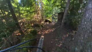
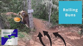
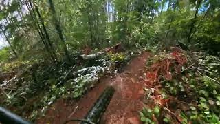
Trail starts on rock outcrop off of Bucket Of Blood with a small but steep roll in. Sign on tree.........hard to missSmile Once you've crossed over A-frame there is a little bit of pedaling and once over the ladder bridge, your in for a bit of fun. Some tight turns and tight trees but nothing that want stop you from threading the needle Watch for some of the larger roots and the odd small stump waiting to slide your tire out. But that's half the fun, right?Smile

Local Trail Association
Traditionally Indigenous Territory
More Stats for Bear Buns mountain bike trail trail
  • Altitude change
    -388 ft
  • Altitude min
    1,127 ft
  • Altitude max
    1,515 ft
  • Altitude start
    1,515 ft
  • Altitude end
    1,129 ft
  • Grade
    -10.1%
  • Grade max
    -27.2%
  • Grade min
    5.9%
  • Distance climb
    125 ft
  • Distance down
    3,514 ft
  • Distance flat
    200 ft
  • Avg time
    00:07:09
  • Avg reverse time
    00:14:02
  • view trail stats
Status:
on Dec 15, 2024
Variable
Avg: 4.1 (46 votes)
Your vote: 0

view (13,393)
close
3D
Trail Conditions
  • Unknown
  • Snow Groomed
  • Snow Packed
  • Snow Covered
  • Snow Cover Partial
  • Freeze/thaw Cycle
  • Icy
  • Prevalent Mud
  • Wet
  • Variable
  • Ideal
  • Dry
  • Very Dry
Trail Flow (Ridden Direction)
Trailforks scans users ridelogs to determine the most popular direction each trail is ridden. A good flowing trail network will have most trails flowing in a single direction according to their intension.
The colour categories are based on what percentage of riders are riding a trail in its intended direction.
  • > 96%
  • > 90%
  • > 80%
  • > 70%
  • > 50%
  • < 50%
  • bi-directional trail
  • no data
Trail Last Ridden
Trailforks scans ridelogs to determine the last time a trail was ridden.
  • < 2 days
  • < 1 week
  • < 2 weeks
  • < 1 month
  • < 6 months
  • > 6 months
Trail Ridden Direction
The intended direction a trail should be ridden.
  • Downhill Only
  • Downhill Primary
  • Both Directions
  • Uphill Primary
  • Uphill Only
  • One Direction
Contribute Details
Colors indicate trail is missing specified detail.
  • Description
  • Photos
  • Description & Photos
  • Videos
Trail Popularity ?
Trailforks scans ridelogs to determine which trails are ridden the most in the last 9 months. Trails are compared with nearby trails in the same city region with a possible 25 colour shades. Think of this as a heatmap, more rides = more kinetic energy = warmer colors.
  • most popular
  • popular
  • less popular
  • not popular
ATV/ORV/OHV Filter
Max Vehicle Width
inches
US Cell Coverage
Legend
cell carrier legend

Radar Time
x Activity Recordings
Trailforks users anonymized public ridelogs from the past 6 months.
  • mountain biking recent
  • mountain biking (>6 month)
  • hiking (1 year)
  • moto (1 year)
Activity Recordings
Trailforks users anonymized public skilogs from the past 12 months.
  • Downhill Ski
  • Backcountry Ski
  • Nordic Ski
  • Snowmobile
Winter Trails
Warning A routing network for winter maps does not exist. Selecting trails using the winter trails layer has been disabled.
x Missing Trails
Most Popular
Least Popular
Trails are colored based on popularity. The more popular a trail is, the more red. Less popular trails trend towards green.
Jump Magnitude Heatmap
Heatmap of where riders jump on trails. Zoom in to see individual jumps, click circles to view jump details.
Trails Deemphasized
Trails are shown in grey.
disable
Only show trails with NO bikes.
enable

Save the current map location and zoom level as your default home location whenever this page is loaded.

Save
      Directions to bear-buns trailhead (49.598520, -125.059410)
      update trails status or condition

      Bear Buns Trail Reports

      statusdatedescription
      Dec 15, 2024 @ 12:38pm
      Dec 15, 2024
      4 moderately large trees down on upper half of Bear Buns. First tree is right after the rock roll at the top.
      Dec 15, 2024 @ 11:55am
      Dec 15, 2024
      Trees down across trail.
      Dec 5, 2024 @ 7:26pm
      Dec 5, 2024
      10” tree/log across trail
      Oct 27, 2024 @ 11:05am
      Oct 27, 2024
      Sep 30, 2024 @ 10:00am
      Sep 30, 2024
      view all reports »

      Recent Ridelog Activity on Trail

      Past Week
      • 0 rides
      •  
      6 Months
      • 232 rides
      • 15 miles avg distance
      All
      • 2,198 rides
      • Last: Feb 2, 2025

      Photos

      more »
      647 |
      Jul 25, 2017 @ 4:07pm
      Jul 25, 2017
      435 |
      Apr 15, 2017 @ 9:58pm
      Apr 15, 2017
      198 |
      May 13, 2022 @ 5:43pm
      May 13, 2022
      168 |
      Apr 27, 2020 @ 9:48am
      Apr 27, 2020

      1 Review & Comments


      We hope you've been enjoying Trailforks!

      Create a FREE account to view trail comments and much more.

      Videos

      more »
      Trail: Bear Buns, Cumberland,BC. With Julia,...
      5:15 | 168 | Jun 23, 2024 , Cumberland
      Bear Buns, Cumberland, BC
      4:04 | 870 | Oct 24, 2021 , Cumberland
      Blueprint, Blockhead and Bear Buns
      8:13 | 328 | Jul 29, 2021 , Cumberland
      Bear Buns
      4:27 | 1114 | Jun 30, 2020 , Cumberland
      • By primodeeluxTF Pro & contributors
      • #397 - 8,985 views

      You must enter a description before submitting.