more stats
1.9 miles
Distance
45 ft
Climb
-828 ft
Descent
00:11:06
Avg time
-783 ft
Altitude change
3,963 ft
Altitude min
4,745 ft
Altitude max
4,745 ft
Altitude start
3,963 ft
Altitude end
-7.8%
Grade
-47.5%
Grade max
15.9%
Grade min
1,204 ft
Distance climb
2 miles
Distance down
46 ft
Distance flat
00:11:06
Avg time

Bear Right Details

  • Activities
    • Mountain Bike
    • Winter Fat Bike
    • Hike
    • Trail Running
    • Snowshoe
  • Riding Area
    The Rattlesnake
    Missoula, Montana
  • Difficulty Rating
  • Local Popularity
    70 in Mountain Biking [+]
    • 60 in Trail Running
    • 55 in Hiking
    • 5 in Snowshoeing
  • Global Ranking
    #88170 in Mountain Biking [+]
    • #107737 in Trail Running
    • #115780 in Hiking
  • Hiking SAC Scale
    T2 Mountain Hiking
  • Trail Type
    Singletrack
  • Snow Grooming
    Backcountry
  • Bike Type
    AM, XC, Fat
  • Direction
    Both Directions
  • Climb Difficulty
    Blue
  • Physical Rating
    Moderate
  • Trail Visibility
    Sometimes hard to follow
  • Dogs Allowed
    Yes
  • eBike Allowed
  • Land Owner
    Lolo National Forest

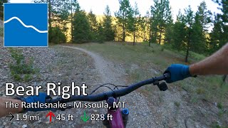
Trail follows an old roadbed that has grown in and narrowed down to singletrack. There are a number of forks with old roads that dead end. In the downhill direction bear right at each intersection to stay on the trail.

Trail Supporters

  • USFS
    Land Manager
Local Trail Association
Traditionally Indigenous Territory

Recent Activity on Trail

Past Week
  • 2 rides
  • 34 miles average
6 Months
  • 15 rides
  • 15 miles avg distance
All
  • 108 rides
  • Last: Jun 27, 2026
c1c2c3c4
January
February
March
April
May
June
July
August
September
October
November
December
update trails status or condition

Bear Right Trail Reports

statusdatedescription
May 3, 2026 @ 12:29pm (America/Denver)
May 3, 2026
There’s a number of trees down. Many could be cleared with a handsaw but a few need a chainsaw. There’s two large trees down just below the...
Sep 22, 2025 @ 7:05am (America/Denver)
Sep 22, 2025
Aug 2, 2025 @ 10:57am
Aug 2, 2025
Jun 6, 2025 @ 1:10pm
Jun 6, 2025
There's a few low hanging trees that could be cleared with a handsaw. The largest one is near bottom just before the first switchback. Overall...
Nov 27, 2024 @ 11:19am
Nov 27, 2024
1-2 inches of snow in sections.
more »
Status:
on May 3, 2026
Ideal
Avg: 3.98 (1 votes)
Your vote: 0

view (526)
close
3D
Trail Conditions
  • Unknown
  • Snow Groomed
  • Snow Packed
  • Snow Covered
  • Snow Cover Partial
  • Freeze/thaw Cycle
  • Icy
  • Prevalent Mud
  • Wet
  • Variable
  • Ideal
  • Dry
  • Very Dry
Trail Flow (Ridden Direction)
Trailforks scans users ridelogs to determine the most popular direction each trail is ridden. A good flowing trail network will have most trails flowing in a single direction according to their intension.
The colour categories are based on what percentage of riders are riding a trail in its intended direction.
  • > 96%
  • > 90%
  • > 80%
  • > 70%
  • > 50%
  • < 50%
  • bi-directional trail
  • no data
Trail Last Ridden
Trailforks scans ridelogs to determine the last time a trail was ridden.
  • < 2 days
  • < 1 week
  • < 2 weeks
  • < 1 month
  • < 6 months
  • > 6 months
Trail Ridden Direction
The intended direction a trail should be ridden.
  • Downhill Only
  • Downhill Primary
  • Both Directions
  • Uphill Primary
  • Uphill Only
  • One Direction
Contribute Details
Colors indicate trail is missing specified detail.
  • Description
  • Photos
  • Description & Photos
  • Videos
Trail Popularity ?
Trailforks scans ridelogs to determine which trails are ridden the most in the last 9 months. Trails are compared with nearby trails in the same city region with a possible 25 colour shades. Think of this as a heatmap, more rides = more kinetic energy = warmer colors.
  • most popular
  • popular
  • less popular
  • not popular
ATV/ORV/OHV Filter
Max Vehicle Width
inches
US Cell Coverage
Legend
cell carrier legend

Radar Time
Activity Recordings
Trailforks uses anonymized public activity data. ?
Activity Recordings
Trailforks uses anonymized public activity data. ?
Personal Heatmap
Activity Types
all / none
Options
2
Date range month
Winter Trails
Warning A routing network for winter maps does not exist. Selecting trails using the winter trails layer has been disabled.
Missing Trails
Most Popular
Least Popular
Trails are colored based on popularity. The more popular a trail is, the more red. Less popular trails trend towards green.
Jump Magnitude Heatmap
Heatmap of where riders jump on trails. Zoom in to see individual jumps, click circles to view jump details.
BC Backroad Status

Service Road Atlas is a free to use, community-driven service for viewing and creating reports on the numerous back-country service roads around B.C. and Alberta.

map legend
Slope Aspect
Direction the slope faces
Flat N NE E SE S SW W NW
Trails Deemphasized
Trails are shown in grey.
disable
Only show trails with no bike usage.
Enable
Suggested Layers
Based on selected activity type

    Save the current map location and zoom level as your default home location whenever this page is loaded.

    Save
        Directions to bear-right trailhead (46.923810, -113.913330)

        Photos

        2 more »
        120 |
        Jun 3, 2020 @ 8:10pm
        Jun 3, 2020
        75 |
        May 3, 2021 @ 7:13pm
        May 3, 2021

        Videos

        1 more »
        youtuber Bear Right - The Rattlesnake - Missoula, MT
        7:22 | 60 | Jul 20, 2025 , Missoula

        4 Reviews & Comments


        We hope you've been enjoying Trailforks!

        Create a FREE account to view trail comments and much more.

        • By aaronrbaldwinTF Pro TRAILFORKS & contributors
        • #127945 - 1,623 views

        Frequently Asked Questions About Bear Right

        Where is Bear Right located?
        Bear Right is located in The Rattlesnake, Missoula, Montana, United States. It is part of the The Rattlesnake trail network. The trailhead is located at coordinates 46.92381, -113.91333.
        How hard is Bear Right?
        Bear Right is rated as Blue difficulty. The physical rating is Moderate. The average grade is 7.8%. The climb difficulty is rated Blue.
        What is the elevation gain for Bear Right?
        Bear Right has 45 ft of elevation gain. The trail has 828 ft of elevation descent. The elevation ranges from 3,963 ft to 4,745 ft.
        Is Bear Right a point to point trail?
        Bear Right is not a point to point trail. The direction is Both Directions. The trail type is singletrack.

        Hit the Trail

        Open in App

        Get this trail on your phone instantly.
        open trail in app

        Download Trail

        Save to wishlist, Garmin & download.
        save the trail

        Find Related Routes

        Find routes and users activities that include this trail.
        find routes for this trail

        You must enter a description before submitting.