more stats
5,276 ft
Distance
-1,031 ft
Descent
00:18:16
Avg time
-1,031 ft
Altitude change
435 ft
Altitude min
1,466 ft
Altitude max
1,466 ft
Altitude start
436 ft
Altitude end
-19.5%
Grade
-44.7%
Grade max
-2.2%
Grade min
5,276 ft
Distance down
00:18:16
Avg time

Bechet Details

  • Activities
    • Mountain Bike
    • E-Bike
    • Horse
    • Hike
    • Trail Running
  • Riding Area
    Bahna
    Iloviţa
  • Difficulty Rating
  • Local Popularity
    5 in Mountain Biking [+]
    • 5 in E-Biking
    • 5 in Trail Running
    • 5 in Hiking
    • 5 in Horseback
  • Global Ranking
    #150617 in Mountain Biking [+]
    • #107153 in E-Biking
    • #142950 in Trail Running
    • #137520 in Hiking
    • #2603 in Horseback
  • Hiking SAC Scale
    T1 Hiking
  • Trail Type
    Singletrack
  • Bike Type
    AM, XC
  • Direction
    Downhill Primary
    Popular Direction Shown
  • Physical Rating
    Easy
  • Trail Visibility
    Always easy to follow
  • Season
    Jan - Dec
  • Dogs Allowed
    Yes
  • eBike Allowed
    Yes up to Class 1
  • TTFs on Trail
    Rock Garden
  • Ride in Rain
    Yes

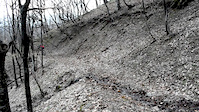
The trail starts from a logging road, going to the right of it. Has plenty of natural obstacles: small rock gardens, some roots, a few tight corners, creek crossings. The straight sections can be really fast. Generally, has a good flow and it's a lot of fun to ride. The surface is pretty loose, with plenty of small rocks.

Access Info

You'll have to follow the logging road and then turn right

This trail is unsanctioned.

Recent Activity on Trail

Past Week
  • 0 rides
  •  
6 Months
  • 0 rides
  •  
All
  • 43 rides
  • Last: Mar 9, 2021
c1c2c3c4
January
February
March
April
May
June
July
August
September
October
November
December
update trails status or condition

Bechet Trail Reports

statusdatedescription
May 3, 2021 @ 7:37am
May 3, 2021
vegetation a bit overgrown already, and the two fallen trees are annoying
Mar 28, 2021 @ 1:06am
Mar 28, 2021
Feb 19, 2021 @ 5:25am
Feb 19, 2021
reporter cleaned the blocked lines, some leaves left but nothing too bad
Jan 27, 2021 @ 5:44am
Jan 27, 2021
reporter
Jan 7, 2021 @ 5:36am
Jan 7, 2021
reporter big fallen trees, full of leaves, needs maintenance
more »
Status:
on May 3, 2021
Dry
Avg: 4.11 (2 votes)
Your vote: 0

view (85)
close
3D
Trail Conditions
  • Unknown
  • Snow Groomed
  • Snow Packed
  • Snow Covered
  • Snow Cover Partial
  • Freeze/thaw Cycle
  • Icy
  • Prevalent Mud
  • Wet
  • Variable
  • Ideal
  • Dry
  • Very Dry
Trail Flow (Ridden Direction)
Trailforks scans users ridelogs to determine the most popular direction each trail is ridden. A good flowing trail network will have most trails flowing in a single direction according to their intension.
The colour categories are based on what percentage of riders are riding a trail in its intended direction.
  • > 96%
  • > 90%
  • > 80%
  • > 70%
  • > 50%
  • < 50%
  • bi-directional trail
  • no data
Trail Last Ridden
Trailforks scans ridelogs to determine the last time a trail was ridden.
  • < 2 days
  • < 1 week
  • < 2 weeks
  • < 1 month
  • < 6 months
  • > 6 months
Trail Ridden Direction
The intended direction a trail should be ridden.
  • Downhill Only
  • Downhill Primary
  • Both Directions
  • Uphill Primary
  • Uphill Only
  • One Direction
Contribute Details
Colors indicate trail is missing specified detail.
  • Description
  • Photos
  • Description & Photos
  • Videos
Trail Popularity ?
Trailforks scans ridelogs to determine which trails are ridden the most in the last 9 months. Trails are compared with nearby trails in the same city region with a possible 25 colour shades. Think of this as a heatmap, more rides = more kinetic energy = warmer colors.
  • most popular
  • popular
  • less popular
  • not popular
ATV/ORV/OHV Filter
Max Vehicle Width
inches
US Cell Coverage
Legend
cell carrier legend

Radar Time
Activity Recordings
Trailforks uses anonymized public activity data. ?
Activity Recordings
Trailforks uses anonymized public activity data. ?
Personal Heatmap
Activity Types
all / none
Options
2
Date range month
Winter Trails
Warning A routing network for winter maps does not exist. Selecting trails using the winter trails layer has been disabled.
Missing Trails
Most Popular
Least Popular
Trails are colored based on popularity. The more popular a trail is, the more red. Less popular trails trend towards green.
Jump Magnitude Heatmap
Heatmap of where riders jump on trails. Zoom in to see individual jumps, click circles to view jump details.
BC Backroad Status

Service Road Atlas is a free to use, community-driven service for viewing and creating reports on the numerous back-country service roads around B.C. and Alberta.

map legend
Slope Aspect
Direction the slope faces
Flat N NE E SE S SW W NW
Trails Deemphasized
Trails are shown in grey.
disable
Only show trails with no bike usage.
Enable
Suggested Layers
Based on selected activity type

    Save the current map location and zoom level as your default home location whenever this page is loaded.

    Save
        Directions to bechet trailhead (44.765820, 22.514400)

        Photos

        14 more »
        83 |
        Oct 19, 2016 @ 11:44am
        Oct 19, 2016
        90 |
        Oct 19, 2016 @ 11:44am
        Oct 19, 2016
        41 |
        Nov 12, 2024 @ 5:32am
        Nov 12, 2024
        81 |
        Apr 9, 2020 @ 9:07am
        Apr 9, 2020

        Videos

        2 more »
        Welcome Spring (raw edit)
        0:04 | 47 | Mar 31, 2018 , Iloviţa
        5:20 | 47 | Feb 10, 2018 , Iloviţa

        Reviews / Comments

        No reviews yet, be the first to write a review or ask a question.
        Use trail reports to comment on trail conditions.


        We hope you've been enjoying Trailforks!

        Create a FREE account to view trail comments and much more.

        • #71220 - 1,132 views

        Frequently Asked Questions About Bechet

        Where is Bechet located?
        Bechet is located in Bahna, Iloviţa, Romania. It is part of the Bahna trail network. The trailhead is located at coordinates 44.76582, 22.5144.
        How hard is Bechet?
        Bechet is rated as Blue difficulty. The physical rating is Easy. The average grade is 19.5%.
        What is the elevation gain for Bechet?
        The trail has 1,031 ft of elevation descent. The elevation ranges from 435 ft to 1,466 ft.
        Is Bechet a point to point trail?
        Bechet is not a point to point trail. The direction is Downhill Primary. The trail type is singletrack.

        Hit the Trail

        Open in App

        Get this trail on your phone instantly.
        open trail in app

        Download Trail

        Save to wishlist, Garmin & download.
        save the trail

        Find Related Routes

        Find routes and users activities that include this trail.
        find routes for this trail

        You must enter a description before submitting.