more stats
5,010 ft
Distance
8 ft
Climb
-253 ft
Descent
00:06:38
Avg time
-244 ft
Altitude change
764 ft
Altitude min
1,019 ft
Altitude max
1,010 ft
Altitude start
768 ft
Altitude end
-4.9%
Grade
-27.7%
Grade max
5.2%
Grade min
387 ft
Distance climb
3,658 ft
Distance down
922 ft
Distance flat
00:06:38
Avg time

Beechdrops Details

  • Activities
    • Mountain Bike
    • E-Bike
    • Snowshoe
  • Riding Area
    Palmer Woods Forest Reserve
    Glen Arbor, Michigan
  • Difficulty Rating
  • Local Popularity
    85 in Mountain Biking [+]
    • 5 in Snowshoeing
  • Trail Type
    Singletrack
  • Bike Type
    AM, XC
  • Direction
    Downhill Only
    Popular Direction Shown
  • Physical Rating
    Moderate
  • Trail Visibility
    Always easy to follow
  • eBike Allowed
  • TTFs on Trail
    Berm, Drop, Jump
  • Year Opened
    2022
  • Land Owner

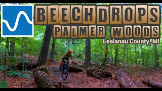
A downhill-only trail linking Fiddlehead with Ursa Major. Fast and flowy with some great berms and jumps. Everything is rollable, so anyone can tackle this trail, but intermediates and experts will most appreciate this trail due to the speed that can be carried and opportunities for air.

Local Trail Association
Traditionally Indigenous Territory

Recent Activity on Trail

Past Week
  • 1 rides
  • 11 miles average
6 Months
  • 9 rides
  • 12 miles avg distance
All
  • 199 rides
  • Last: Jun 4, 2026
c1c2c3c4
January
February
March
April
May
June
July
August
September
October
November
December
update trails status or condition

Beechdrops Trail Reports

Status:
on Oct 27, 2025
Ideal
Avg: 4.44 (5 votes)
Your vote: 0

view (1,361)
close
3D
Trail Conditions
  • Unknown
  • Snow Groomed
  • Snow Packed
  • Snow Covered
  • Snow Cover Partial
  • Freeze/thaw Cycle
  • Icy
  • Prevalent Mud
  • Wet
  • Variable
  • Ideal
  • Dry
  • Very Dry
Trail Flow (Ridden Direction)
Trailforks scans users ridelogs to determine the most popular direction each trail is ridden. A good flowing trail network will have most trails flowing in a single direction according to their intension.
The colour categories are based on what percentage of riders are riding a trail in its intended direction.
  • > 96%
  • > 90%
  • > 80%
  • > 70%
  • > 50%
  • < 50%
  • bi-directional trail
  • no data
Trail Last Ridden
Trailforks scans ridelogs to determine the last time a trail was ridden.
  • < 2 days
  • < 1 week
  • < 2 weeks
  • < 1 month
  • < 6 months
  • > 6 months
Trail Ridden Direction
The intended direction a trail should be ridden.
  • Downhill Only
  • Downhill Primary
  • Both Directions
  • Uphill Primary
  • Uphill Only
  • One Direction
Contribute Details
Colors indicate trail is missing specified detail.
  • Description
  • Photos
  • Description & Photos
  • Videos
Trail Popularity ?
Trailforks scans ridelogs to determine which trails are ridden the most in the last 9 months. Trails are compared with nearby trails in the same city region with a possible 25 colour shades. Think of this as a heatmap, more rides = more kinetic energy = warmer colors.
  • most popular
  • popular
  • less popular
  • not popular
ATV/ORV/OHV Filter
Max Vehicle Width
inches
US Cell Coverage
Legend
cell carrier legend

Radar Time
Activity Recordings
Trailforks uses anonymized public activity data. ?
Activity Recordings
Trailforks uses anonymized public activity data. ?
Personal Heatmap
Activity Types
all / none
Options
2
Date range month
Winter Trails
Warning A routing network for winter maps does not exist. Selecting trails using the winter trails layer has been disabled.
Missing Trails
Most Popular
Least Popular
Trails are colored based on popularity. The more popular a trail is, the more red. Less popular trails trend towards green.
Jump Magnitude Heatmap
Heatmap of where riders jump on trails. Zoom in to see individual jumps, click circles to view jump details.
BC Backroad Status

Service Road Atlas is a free to use, community-driven service for viewing and creating reports on the numerous back-country service roads around B.C. and Alberta.

map legend
Slope Aspect
Direction the slope faces
Flat N NE E SE S SW W NW
Trails Deemphasized
Trails are shown in grey.
disable
Only show trails with no bike usage.
Enable
Suggested Layers
Based on selected activity type

    Save the current map location and zoom level as your default home location whenever this page is loaded.

    Save
        Directions to beechdrops trailhead (44.907580, -85.926260)

        Photos

        No photos have been added for Beechdrops yet, add a photo.

        Videos

        1 more »
        Beechdrops Trail | Palmer Woods | Leelaneau, MI
        4:27 | 321 | Oct 18, 2023 , Glen Arbor

        2 Reviews & Comments


        We hope you've been enjoying Trailforks!

        Create a FREE account to view trail comments and much more.

        • By linden44TF Pro TOMMBA & contributors
        • #538000 - 1,049 views

        Frequently Asked Questions About Beechdrops

        Where is Beechdrops located?
        Beechdrops is located in Palmer Woods Forest Reserve, Glen Arbor, Michigan, United States. It is part of the Palmer Woods Forest Reserve trail network. The trailhead is located at coordinates 44.90758, -85.92626.
        How hard is Beechdrops?
        Beechdrops is rated as Blue difficulty. The physical rating is Moderate. The average grade is 4.9%.
        What is the elevation gain for Beechdrops?
        Beechdrops has 8 ft of elevation gain. The trail has 253 ft of elevation descent. The elevation ranges from 764 ft to 1,019 ft.
        Is Beechdrops a point to point trail?
        Yes, Beechdrops is a point to point trail. The direction is Downhill Only. The trail type is singletrack.

        Hit the Trail

        Open in App

        Get this trail on your phone instantly.
        open trail in app

        Download Trail

        Save to wishlist, Garmin & download.
        save the trail

        Find Related Routes

        Find routes and users activities that include this trail.
        find routes for this trail

        You must enter a description before submitting.