more stats
2.3 miles
Distance
497 ft
Climb
-487 ft
Descent
00:20:06
Avg time
8 ft
Altitude change
6,279 ft
Altitude min
6,553 ft
Altitude max
6,295 ft
Altitude start
6,302 ft
Altitude end
0.1%
Grade
-35.3%
Grade max
35.6%
Grade min
1 mile
Distance climb
4,974 ft
Distance down
1,457 ft
Distance flat
00:20:06
Avg time

Benjamin Loop Details

  • Activities
    • Mountain Bike
    • Hike
    • Trail Running
  • Riding Area
    Betasso Preserve
    Boulder, Colorado
  • Difficulty Rating
  • Local Popularity
    90 in Mountain Biking [+]
    • 65 in Trail Running
    • 75 in Hiking
  • Global Ranking
    #32415 in Mountain Biking [+]
    • #82909 in Trail Running
    • #62935 in Hiking
  • Trail Type
    Singletrack
  • Direction
    Both Directions
  • Climb Difficulty
    Blue
  • Physical Rating
    Moderate
  • Dogs Allowed
    Yes
  • eBike Allowed
  • Land Owner

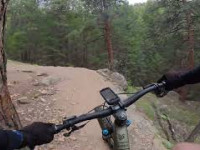
Benjamin Loop is directional for bikers, and the direction changes approximately every four weeks. Please follow posted signs. The preferred direction from the Link Loop is clockwise (not that you have a choice, just be excited if that's the direction du jour). A moderate climb is rewarded with a swoopy descent through the pine trees that will have you feeling like Princess Leia on Endor (watch out for oncoming Stormtroopers). The are a few rocks and a little bit of exposure that may make this trail tricky for beginners.

Disclaimer

Trail closed to bikes on Wednesday and Saturdays. Please ride the posted direction.

Local Trail Association
Traditionally Indigenous Territory

Recent Activity on Trail

Past Week
  • 5 rides
  • 12 miles average
6 Months
  • 115 rides
  • 12 miles avg distance
All
  • 847 rides
  • Last: Jun 7, 2026
c1c2c3c4
January
February
March
April
May
June
July
August
September
October
November
December
Status:
on May 22, 2026
Ideal
Avg: 4 (15 votes)
Your vote: 0

view (9,480)
close
3D
Trail Conditions
  • Unknown
  • Snow Groomed
  • Snow Packed
  • Snow Covered
  • Snow Cover Partial
  • Freeze/thaw Cycle
  • Icy
  • Prevalent Mud
  • Wet
  • Variable
  • Ideal
  • Dry
  • Very Dry
Trail Flow (Ridden Direction)
Trailforks scans users ridelogs to determine the most popular direction each trail is ridden. A good flowing trail network will have most trails flowing in a single direction according to their intension.
The colour categories are based on what percentage of riders are riding a trail in its intended direction.
  • > 96%
  • > 90%
  • > 80%
  • > 70%
  • > 50%
  • < 50%
  • bi-directional trail
  • no data
Trail Last Ridden
Trailforks scans ridelogs to determine the last time a trail was ridden.
  • < 2 days
  • < 1 week
  • < 2 weeks
  • < 1 month
  • < 6 months
  • > 6 months
Trail Ridden Direction
The intended direction a trail should be ridden.
  • Downhill Only
  • Downhill Primary
  • Both Directions
  • Uphill Primary
  • Uphill Only
  • One Direction
Contribute Details
Colors indicate trail is missing specified detail.
  • Description
  • Photos
  • Description & Photos
  • Videos
Trail Popularity ?
Trailforks scans ridelogs to determine which trails are ridden the most in the last 9 months. Trails are compared with nearby trails in the same city region with a possible 25 colour shades. Think of this as a heatmap, more rides = more kinetic energy = warmer colors.
  • most popular
  • popular
  • less popular
  • not popular
ATV/ORV/OHV Filter
Max Vehicle Width
inches
US Cell Coverage
Legend
cell carrier legend

Radar Time
Activity Recordings
Trailforks uses anonymized public activity data. ?
Activity Recordings
Trailforks uses anonymized public activity data. ?
Personal Heatmap
Activity Types
all / none
Options
2
Date range month
Winter Trails
Warning A routing network for winter maps does not exist. Selecting trails using the winter trails layer has been disabled.
Missing Trails
Most Popular
Least Popular
Trails are colored based on popularity. The more popular a trail is, the more red. Less popular trails trend towards green.
Jump Magnitude Heatmap
Heatmap of where riders jump on trails. Zoom in to see individual jumps, click circles to view jump details.
BC Backroad Status

Service Road Atlas is a free to use, community-driven service for viewing and creating reports on the numerous back-country service roads around B.C. and Alberta.

map legend
Slope Aspect
Direction the slope faces
Flat N NE E SE S SW W NW
Trails Deemphasized
Trails are shown in grey.
disable
Only show trails with no bike usage.
Enable
Suggested Layers
Based on selected activity type

    Save the current map location and zoom level as your default home location whenever this page is loaded.

    Save
        Directions to benjamin-loop trailhead (40.028770, -105.343560)

        Photos

        9 more »
        29 |
        Apr 24, 2026 @ 3:07pm
        Apr 24, 2026
        29 |
        Apr 24, 2026 @ 3:07pm
        Apr 24, 2026
        191 |
        Nov 8, 2023 @ 6:11pm
        Nov 8, 2023
        173 |
        Nov 8, 2023 @ 6:11pm
        Nov 8, 2023

        Videos

        4 more »
        Benjamin Loop
        92 | Jun 25, 2025 , Boulder
        youtuber Canyon Loop & Benjamin Loop
        9:50 | 365 | Aug 25, 2023 , Boulder
        Fat Biking at Betasso Preserve!  Boulder -...
        0:01 | 258 | Jan 23, 2023 , Boulder
        Benjamin Loop - Betasso Preserve - Boulder,...
        8:52 | 835 | Jun 4, 2021 , Boulder

        Trail Lists

        Routes with this trail

        Betasso Loops Featured
        3.4 7 miles 950 ft 9 Loop
        Betasso Preserve is a great intermediate area close to downtown Boulder. Because of its popularity, bikes...
        Super Betasso Featured
        3.0 16 miles 2,128 ft 7 Loop
        In Boulder, a Super ride is one that starts from town, rather than at the trailhead. So start your Super...
        7 miles 949 ft 3 Loop

        4 Reviews & Comments


        We hope you've been enjoying Trailforks!

        Create a FREE account to view trail comments and much more.

        • By toddTF Pro Trailforks & contributors
        • #13661 - 5,091 views

        Frequently Asked Questions About Benjamin Loop

        Where is Benjamin Loop located?
        Benjamin Loop is located in Betasso Preserve, Boulder, Colorado, United States. It is part of the Betasso Preserve trail network. The trailhead is located at coordinates 40.02877, -105.34356.
        How hard is Benjamin Loop?
        Benjamin Loop is rated as Blue difficulty. The physical rating is Moderate. The average grade is 0.1%. The climb difficulty is rated Blue.
        What is the elevation gain for Benjamin Loop?
        Benjamin Loop has 497 ft of elevation gain. The trail has 487 ft of elevation descent. The elevation ranges from 6,279 ft to 6,553 ft.
        Is Benjamin Loop a point to point trail?
        Benjamin Loop is not a point to point trail. The direction is Both Directions. The trail type is singletrack.

        Hit the Trail

        Open in App

        Get this trail on your phone instantly.
        open trail in app

        Download Trail

        Save to wishlist, Garmin & download.
        save the trail

        Find Related Routes

        Find routes and users activities that include this trail.
        find routes for this trail

        You must enter a description before submitting.