more stats
889 ft
Distance
-80 ft
Descent
00:01:09
Avg time
-80 ft
Altitude change
3,532 ft
Altitude min
3,613 ft
Altitude max
3,613 ft
Altitude start
3,533 ft
Altitude end
-9%
Grade
-32.9%
Grade max
-2.2%
Grade min
869 ft
Distance down
20 ft
Distance flat
00:01:09
Avg time

Berm Blaster Details

  • Activities
    • Mountain Bike
    • E-Bike
    • Hike
    • Trail Running
  • Riding Area
    Fish Creek Provincial Park
    Calgary, Alberta
  • Difficulty Rating
  • Local Popularity
    90 in Mountain Biking [+]
    • 90 in E-Biking
    • 85 in Trail Running
    • 85 in Hiking
  • Global Ranking
    #29796 in Mountain Biking [+]
    • #53117 in Trail Running
    • #56298 in Hiking
  • Trail Type
    Singletrack
  • Bike Type
    AM, XC
  • Direction
    Downhill Primary
    Popular Direction Shown
  • Physical Rating
    Easy
  • Dogs Allowed
    Yes
  • eBike Allowed
  • TTFs on Trail
    Drop, Jump
  • Land Owner
    Alberta Parks

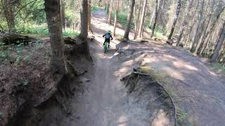
Berm Blaster is a short, but super fun trail Fast straight away to start, into a quick S-bend, followed again by a long straight away with a jump and then a nice natural berm to rail around. Let go of the brakes and go nuts!

Watch out for hikers/dog walkers as they have the right of way.

Access Info

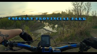
At the end of the pathway, trail head is on the riders most left. Biking sign marks trail head.

Recent Activity on Trail

Past Week
  • 1 rides
  • 10 miles average
6 Months
  • 34 rides
  • 12 miles avg distance
All
  • 579 rides
  • Last: Jun 26, 2026
c1c2c3c4
January
February
March
April
May
June
July
August
September
October
November
December
update trails status or condition

Berm Blaster Trail Reports

Status:
on Sep 12, 2025
Ideal
Avg: 4.33 (13 votes)
Your vote: 0

view (3,795)
close
3D
Trail Conditions
  • Unknown
  • Snow Groomed
  • Snow Packed
  • Snow Covered
  • Snow Cover Partial
  • Freeze/thaw Cycle
  • Icy
  • Prevalent Mud
  • Wet
  • Variable
  • Ideal
  • Dry
  • Very Dry
Trail Flow (Ridden Direction)
Trailforks scans users ridelogs to determine the most popular direction each trail is ridden. A good flowing trail network will have most trails flowing in a single direction according to their intension.
The colour categories are based on what percentage of riders are riding a trail in its intended direction.
  • > 96%
  • > 90%
  • > 80%
  • > 70%
  • > 50%
  • < 50%
  • bi-directional trail
  • no data
Trail Last Ridden
Trailforks scans ridelogs to determine the last time a trail was ridden.
  • < 2 days
  • < 1 week
  • < 2 weeks
  • < 1 month
  • < 6 months
  • > 6 months
Trail Ridden Direction
The intended direction a trail should be ridden.
  • Downhill Only
  • Downhill Primary
  • Both Directions
  • Uphill Primary
  • Uphill Only
  • One Direction
Contribute Details
Colors indicate trail is missing specified detail.
  • Description
  • Photos
  • Description & Photos
  • Videos
Trail Popularity ?
Trailforks scans ridelogs to determine which trails are ridden the most in the last 9 months. Trails are compared with nearby trails in the same city region with a possible 25 colour shades. Think of this as a heatmap, more rides = more kinetic energy = warmer colors.
  • most popular
  • popular
  • less popular
  • not popular
ATV/ORV/OHV Filter
Max Vehicle Width
inches
US Cell Coverage
Legend
cell carrier legend

Radar Time
Activity Recordings
Trailforks uses anonymized public activity data. ?
Activity Recordings
Trailforks uses anonymized public activity data. ?
Personal Heatmap
Activity Types
all / none
Options
2
Date range month
Winter Trails
Warning A routing network for winter maps does not exist. Selecting trails using the winter trails layer has been disabled.
Missing Trails
Most Popular
Least Popular
Trails are colored based on popularity. The more popular a trail is, the more red. Less popular trails trend towards green.
Jump Magnitude Heatmap
Heatmap of where riders jump on trails. Zoom in to see individual jumps, click circles to view jump details.
BC Backroad Status

Service Road Atlas is a free to use, community-driven service for viewing and creating reports on the numerous back-country service roads around B.C. and Alberta.

map legend
Slope Aspect
Direction the slope faces
Flat N NE E SE S SW W NW
Trails Deemphasized
Trails are shown in grey.
disable
Only show trails with no bike usage.
Enable
Suggested Layers
Based on selected activity type

    Save the current map location and zoom level as your default home location whenever this page is loaded.

    Save
        Directions to berm-blaster trailhead (50.924187, -114.118160)

        Photos

        17 more »
        21 |
        Jun 7, 2026 @ 6:32pm
        Jun 7, 2026
        15 |
        Jun 7, 2026 @ 6:32pm
        Jun 7, 2026
        509 |
        May 10, 2020 @ 4:41pm
        May 10, 2020
        263 |
        Apr 16, 2020 @ 9:04pm
        Apr 16, 2020

        Videos

        4 more »
        Fish Creek Provincial Park - My local trails,...
        13:06 | 335 | May 26, 2024 , Calgary
        Fish Creek Park MTB -  Bermblaster & Sluice
        3:27 | 254 | Sep 6, 2023 , Calgary
        5 year ood on Berm Blaster, Fish Creek PP
        0:56 | 424 | Aug 14, 2021 , Calgary
        Bermblaster (fish Creek)
        0:45 | 1270 | May 17, 2018 , Calgary

        Routes with this trail

        8 miles 627 ft 13 Loop
        Welcome to Fish Creek - Trails maintained in part by the Calgary Mountain Bike Alliance (CMBA). This is a...
        15 miles 1,083 ft 22 Loop
        1) Start at Glenfield parking lot. 2) Go under the MacLeod Tr overpass. 3) Go over bridge to north side...
        8 miles 699 ft 11 Loop
        For anyone that loves riding in Fish Creek. This route pretty much hits all the technical trails on the...

        4 Reviews & Comments


        We hope you've been enjoying Trailforks!

        Create a FREE account to view trail comments and much more.

        • By acdownhillTF Pro & contributors
        • #19500 - 9,388 views

        Frequently Asked Questions About Berm Blaster

        Where is Berm Blaster located?
        Berm Blaster is located in Fish Creek Provincial Park, Calgary, Alberta, Canada. It is part of the Fish Creek Provincial Park trail network. The trailhead is located at coordinates 50.92419, -114.11816.
        How hard is Berm Blaster?
        Berm Blaster is rated as Blue difficulty. The physical rating is Easy. The average grade is 9%.
        What is the elevation gain for Berm Blaster?
        The trail has 80 ft of elevation descent. The elevation ranges from 3,532 ft to 3,613 ft.
        Is Berm Blaster a point to point trail?
        Berm Blaster is not a point to point trail. The direction is Downhill Primary. The trail type is singletrack.

        Hit the Trail

        Open in App

        Get this trail on your phone instantly.
        open trail in app

        Download Trail

        Save to wishlist, Garmin & download.
        save the trail

        Find Related Routes

        Find routes and users activities that include this trail.
        find routes for this trail

        You must enter a description before submitting.