more stats
1,955 ft
Distance
-189 ft
Descent
00:04:01
Avg time
-189 ft
Altitude change
675 ft
Altitude min
864 ft
Altitude max
864 ft
Altitude start
676 ft
Altitude end
-9.7%
Grade
-34.5%
Grade max
-1.2%
Grade min
1,709 ft
Distance down
246 ft
Distance flat
00:04:01
Avg time

Binx Details

  • Activities
    • Mountain Bike
    • Hike
    • Trail Running
  • Riding Area
    Westwood
    Nanaimo, British Columbia
  • Difficulty Rating
  • Voted Difficulty
    Blue (1 vote)
  • Local Popularity
    100 in Mountain Biking [+]
    • 90 in Trail Running
    • 70 in Hiking
  • Global Ranking
    #32351 in Mountain Biking [+]
    • #34442 in Trail Running
    • #81503 in Hiking
  • Trail Type
    Singletrack
  • Bike Type
    AM, XC
  • Direction
    Downhill Only
    Popular Direction Shown
  • Dogs Allowed
    Yes
  • TTFs on Trail
    Berm, Jump

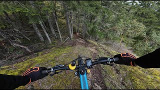
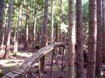
Old Downhill Trail that has seen some work by our paid trail crew this year
Progressive rollers, a cool wood feature and a table at the bottom, look before you leap

Downhill trafic only

Trail Supporters
Local Trail Association
Traditionally Indigenous Territory

Recent Activity on Trail

Past Week
  • 127 rides
  • 35.6 km average
6 Months
  • 338 rides
  • 20.3 km avg distance
All
  • 2,452 rides
  • Last: Jun 2, 2026
c1c2c3c4
January
February
March
April
May
June
July
August
September
October
November
December
Status:
on Apr 30, 2026
Ideal
Avg: 4.41 (11 votes)
Your vote: 0

view (11,381)
close
3D
Trail Conditions
  • Unknown
  • Snow Groomed
  • Snow Packed
  • Snow Covered
  • Snow Cover Partial
  • Freeze/thaw Cycle
  • Icy
  • Prevalent Mud
  • Wet
  • Variable
  • Ideal
  • Dry
  • Very Dry
Trail Flow (Ridden Direction)
Trailforks scans users ridelogs to determine the most popular direction each trail is ridden. A good flowing trail network will have most trails flowing in a single direction according to their intension.
The colour categories are based on what percentage of riders are riding a trail in its intended direction.
  • > 96%
  • > 90%
  • > 80%
  • > 70%
  • > 50%
  • < 50%
  • bi-directional trail
  • no data
Trail Last Ridden
Trailforks scans ridelogs to determine the last time a trail was ridden.
  • < 2 days
  • < 1 week
  • < 2 weeks
  • < 1 month
  • < 6 months
  • > 6 months
Trail Ridden Direction
The intended direction a trail should be ridden.
  • Downhill Only
  • Downhill Primary
  • Both Directions
  • Uphill Primary
  • Uphill Only
  • One Direction
Contribute Details
Colors indicate trail is missing specified detail.
  • Description
  • Photos
  • Description & Photos
  • Videos
Trail Popularity ?
Trailforks scans ridelogs to determine which trails are ridden the most in the last 9 months. Trails are compared with nearby trails in the same city region with a possible 25 colour shades. Think of this as a heatmap, more rides = more kinetic energy = warmer colors.
  • most popular
  • popular
  • less popular
  • not popular
ATV/ORV/OHV Filter
Max Vehicle Width
inches
US Cell Coverage
Legend
cell carrier legend

Radar Time
Activity Recordings
Trailforks uses anonymized public activity data. ?
Activity Recordings
Trailforks uses anonymized public activity data. ?
Personal Heatmap
Activity Types
all / none
Options
2
Date range month
Winter Trails
Warning A routing network for winter maps does not exist. Selecting trails using the winter trails layer has been disabled.
Missing Trails
Most Popular
Least Popular
Trails are colored based on popularity. The more popular a trail is, the more red. Less popular trails trend towards green.
Jump Magnitude Heatmap
Heatmap of where riders jump on trails. Zoom in to see individual jumps, click circles to view jump details.
BC Backroad Status

Service Road Atlas is a free to use, community-driven service for viewing and creating reports on the numerous back-country service roads around B.C. and Alberta.

map legend
Slope Aspect
Direction the slope faces
Flat N NE E SE S SW W NW
Trails Deemphasized
Trails are shown in grey.
disable
Only show trails with no bike usage.
Enable
Suggested Layers
Based on selected activity type

    Save the current map location and zoom level as your default home location whenever this page is loaded.

    Save
        Directions to binx trailhead (49.159920, -124.017860)

        Photos

        105 more »
        948 |
        May 20, 2008 @ 12:18am
        May 20, 2008
        1,001 |
        May 20, 2008 @ 5:29pm
        May 20, 2008
        121 |
        Jan 16, 2022 @ 8:46pm
        Jan 16, 2022
        112 |
        Dec 20, 2021 @ 7:59pm
        Dec 20, 2021

        Videos

        4 more »
        Rocks N Chutes at Westwood Lake | Nanaimo, BC
        7:54 | 94 | Apr 13, 2025 , Nanaimo
        Full Gas Fun | Binx, Nanaimo B.C. Nathan's...
        212 | May 4, 2022 , Nanaimo
        roller coaster
        0:15 | 5927 | Dec 17, 2007 , Nanaimo
        binx pictures
        2:40 | 345 | Oct 25, 2009 , Nanaimo

        Routes with this trail

        3.7 23 miles 3,114 ft 17
        BCBR 2025 Stage 4 Nanaimo. An XC heavy, steady load day in the amazing and varied landscapes of Nanaimo
        4.0 23 miles 2,916 ft 19
        Stage 6 BCBR: A mix of riding styles; distinct terrain, Big Bang Cidery to finish!
        5.0 10 miles 1,502 ft 35
        Discovery ride to check the highlights of westwood

        3 Reviews & Comments


        We hope you've been enjoying Trailforks!

        Create a FREE account to view trail comments and much more.

        • By dubelyewTF Pro & contributors
        • #35225 - 5,278 views

        Frequently Asked Questions About Binx

        Where is Binx located?
        Binx is located in Westwood, Nanaimo, British Columbia, Canada. It is part of the Westwood trail network. The trailhead is located at coordinates 49.15992, -124.01786.
        How hard is Binx?
        Binx is rated as Blue difficulty. The average grade is 9.7%.
        What is the elevation gain for Binx?
        The trail has 58 m of elevation descent. The elevation ranges from 206 m to 263 m.
        Is Binx a point to point trail?
        Yes, Binx is a point to point trail. The direction is Downhill Only. The trail type is singletrack.

        Hit the Trail

        Open in App

        Get this trail on your phone instantly.
        open trail in app

        Download Trail

        Save to wishlist, Garmin & download.
        save the trail

        Find Related Routes

        Find routes and users activities that include this trail.
        find routes for this trail

        You must enter a description before submitting.