


Open in App
Get this trail on your phone instantly.

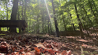
This is the hardest of the loops at Fountainhead. The trail is mostly more of a harder blue with several obstacles that really earn the black diamond rating. The start doesn't hold back with a hard rock climb from the blue trail. From there it eases off for a while. You'll have real fun flowy sections with short climbs and man-made rock gardens thrown in for good measure.
Later in the trail is when it starts to get real. I think it was around mile marker 6, that the drops start. While some of them are small and could be done by most intermediate riders, they get bigger as they go. I think the biggest is about a 6 foot vertical drop. So if you don't feel confident on medium/large drops, you'll want to scope them first. If you are comfortable, then most are pretty mellow, however one has a short landing that took me by surprise. So don't just bomb off them.
After the drop section there's a few more gnar parts, including one pretty rowdy rock garden. When you hit the little A-frame wooden features, you're coming up to it. Just know, it's going to get rocky and chunky.
The end of the trail has an easy and harder route, with the harder ending in a fun and wild decent with rocks and drops everywhere.
If you're an intermediate looking for some harder terrain, give this a go. You can easily go around the hard sections and the rest of the trail is pretty much a blue. Just keep in mind the full loop is around 12 miles.
| c1 | c2 | c3 | c4 |
|---|---|---|---|
January | February | March | April |
May | June | July | August |
September | October | November | December |

Service Road Atlas is a free to use, community-driven service for viewing and creating reports on the numerous back-country service roads around B.C. and Alberta.
Save the current map location and zoom level as your default home location whenever this page is loaded.
Save Other A-Frame


 Wallride Drop Skinny Rock Garden Skinny Other Drop Drop Skinny A-Frame Drop Pump Track Other Jump Other Drop Drop Rock Garden Rock Garden Rock Garden Rock Garden Rock Garden Drop Rock Garden Rock Garden Log Ride Drop Rock Garden Log Ride Rock Garden
We hope you've been enjoying Trailforks!
Create a FREE account to view trail comments and much more.
You must enter a description before submitting.

