more stats
3,891 ft
Distance
-311 ft
Descent
00:05:30
Avg time
-311 ft
Altitude change
182 ft
Altitude min
493 ft
Altitude max
493 ft
Altitude start
184 ft
Altitude end
-8%
Grade
-22.5%
Grade max
1%
Grade min
3,323 ft
Distance down
568 ft
Distance flat
00:05:30
Avg time

Blind Tiger Details

  • Activities
    • Mountain Bike
    • E-Bike
  • Riding Area
    Whiskey Run Trails
    Coos Bay, Oregon
  • Difficulty Rating
  • Local Popularity
    75 in Mountain Biking [+]
    • 75 in E-Biking
  • Global Ranking
    #2015 in Mountain Biking [+]
    • #14247 in E-Biking
  • State Ranking
    #32 in Mountain Biking · Oregon [+]
    • #111 in E-Biking
  • Trail Type
    Singletrack
  • Direction
    One Direction
    Popular Direction Shown
  • eBike Allowed
    Yes up to Class 1
  • Land Owner
    Coos County Forest

Blind Tiger starts off at the top Volstead Hub with some rolling berms and turns before diving into the woods. There is an option Gap Drop that is marked with signs, but be aware at speeds. The go-around turns instead of heading straight down the gap drop. Remember to pre-ride, re-ride, then rip. This area is known for features that keep riders on their toes so please use caution and ride at your own risk. You can ride this trail partially down to the logging road then climb back up, or continue down for more fun.

Tags
BermsJumps

Local Trail Association

Traditionally Indigenous Territory

Recent Activity on Trail

Past Week
  • 0 rides
  •  
6 Months
  • 47 rides
  • 13 miles avg distance
All
  • 250 rides
  • Last: Sep 15, 2026
update trails status or condition

Blind Tiger Trail Reports

statusdatedescription
Sep 15, 2026 @ 9:05am (America/Los_Angeles)
Sep 15, 2026
The volstead side is closed for logging as of 9-15-26. Wild Coast Trails Association will post any updates that we get from the county.
Jul 17, 2026 @ 7:44pm (America/Los_Angeles)
Jul 17, 2026
Top has been weedwacked. Running well. Easy to find trail after logging road.
Jul 6, 2026 @ 11:32am (America/Los_Angeles)
Jul 6, 2026
Logging road cut in the middle of the trail, must walk ~100 ft after the gap drop. Signage for drops were removed.
Jun 30, 2026 @ 11:18am (America/Boise)
Jun 30, 2026
Apr 28, 2026 @ 8:45pm (America/Los_Angeles)
Apr 28, 2026
Upper half is quite rough. Section after road crossing has a good bit of debris, but then runs great. The dirt mound on the gap jump landing is...
more »
Status:
on Sep 15, 2026
Avg: 4.39 (4 votes)
Your vote: 0

view (1,328)
close
      Directions to blind-tiger trailhead (43.211190, -124.334700)

      Photos

      4 more »
      mtb
      198 |
      Jun 29, 2024 @ 6:25am
      Jun 29, 2024
      mtb
      198 |
      Jun 28, 2024 @ 11:03am
      Jun 28, 2024
      mtb
      167 |
      Jun 28, 2024 @ 11:00am
      Jun 28, 2024
      mtb
      139 |
      Jun 28, 2024 @ 11:00am
      Jun 28, 2024

      Videos

      1 more »
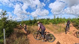
      Whiskey Run | Blind Tiger 08-17-2025 (Top Section)
      mtb
      0:59 | 96 | Aug 18, 2025 , Coos Bay

      Routes with this trail

      ★ 3.0 • 20 miles • 3,880 ft • 24 • Loop •
      Put your legs to work on this 20 mile ups and downs on some of Whiskey Run's best advanced trails. Warm up...
      14 miles • 2,755 ft • 14 • Loop •
      I edited the Trail Builder's Choice route to suit my personal taste.
      12 miles • 2,504 ft • 27 • Loop •
      The prohibition is lifted, time to get wet. Check out laps on the Volstead area (Phase 3) of Whiskey Run...
      5.0 ★★★★★
      4 Ratings
      5 ★ 100%
      4 ★
      3 ★
      2 ★
      1 ★

      7 Reviews & Comments

      Sms226 Sms226
      Open as of July 4, 2026. There is a logging road you must walk at the bottom section (~100 ft) and find the trail on the other side. The warning signs for drops are not installed.
      ColeSorensen ColeSorensen
      Great trail! Very compact and flowy at the top, once you enter the trees there is a perfect log drop that isn't too difficult with a nice ride around if you don't feel comfortable with it. The rest of the trees are fast and loamy with some roots here and there. There is a log gap jump that I did not feel comfortable with but would love to see someone else do it before committing to it myself. Would say this is my second favorite trail here behind Gnome Wrecker.
      Dangerhill
      Fun trail. Small complaints. One large drop that is not rollable has a go around (there is a small sign). Another very large gap jump after trail splits that does not have a ride around. These mandatory features are different from the gnome and loam. Both easily fixed by making the drop rollable with a few boulders behind it and making a tabletop out of gap or making a well done ride around . This would be more consistent with black trails in other ride centers in Oregon and Washington.

      We hope you've been enjoying Trailforks!

      Create a FREE account to view all trail reviews and much more.

      • By ptrailsEKTF Pro & contributors
      • #470197 - 1,710 views

      Frequently Asked Questions

      ▼ Where is Blind Tiger located?
      Blind Tiger is located in Whiskey Run Trails, Coos Bay, Oregon, United States. It is part of the Whiskey Run Trails trail network. The trailhead is located at coordinates 43.21119, -124.3347.
      ▼ How hard is Blind Tiger?
      Blind Tiger is rated as Black Diamond difficulty. The average grade is 8%.
      ▼ What is the elevation gain for Blind Tiger?
      The trail has 311 ft of elevation descent. The elevation ranges from 182 ft to 493 ft.
      ▼ Is Blind Tiger a point to point trail?
      Yes, Blind Tiger is a point to point trail. The direction is One Direction. The trail type is singletrack.
      ▼ How long is Blind Tiger?
      Blind Tiger is 3,891 ft long. The trail type is singletrack.
      ▼ Are dogs allowed on Blind Tiger?
      There is no information about dogs being allowed on Blind Tiger. Check with local trail managers or the trail page for the latest access rules.
      ▼ How do I access Blind Tiger? Where is the closest parking trailhead?
      The closest parking and trailhead locations to Blind Tiger are: View all parking locations in the area.
      ▼ How long does it take to ride Blind Tiger?
      Based on recorded activities, it takes an average of 6 minutes to ride Blind Tiger. The trail is 3,891 ft long. Actual times will vary based on fitness level, conditions, and pace. View recent activity logs for more details.
      ▼ How busy is Blind Tiger?
      Blind Tiger is a very popular trail. There have been 1,226 recorded activities on this trail. The trail has received 1,328 check-ins. View recent activity on this trail.

      Hit the Trail

      Open in App

      Get this trail on your phone instantly.

      open trail in app

      Download Trail

      Save to wishlist, Garmin & download.
      save the trail

      Find Related Routes

      Find routes and users activities that include this trail.
      find routes for this trail

      You must enter a description before submitting.