
more stats
1.3 miles
Distance
113 ft
Climb
-171 ft
Descent
00:08:28
Avg time
-61 ft
Altitude change
1,316 ft
Altitude min
1,398 ft
Altitude max
1,377 ft
Altitude start
1,316 ft
Altitude end
-0.9%
Grade
-15.2%
Grade max
18%
Grade min
2,014 ft
Distance climb
2,618 ft
Distance down
2,031 ft
Distance flat
00:08:28
Avg time

Bloodstone Details

  • Activities
    • Mountain Bike
    • E-Bike
    • Winter Fat Bike
    • Snowshoe
  • Riding Area
    Tioga Recreation Area
    Cohasset, Minnesota
  • Difficulty Rating
  • Local Popularity
    35 in Mountain Biking heatmap [+]
    • 25 in E-Biking
    • 5 in Snowshoeing
    • 5 in Winter Fat Biking
  • Global Ranking
    #91200 in Mountain Biking [+]
    • #125440 in E-Biking
    • #3923 in Snowshoeing
    • #3005 in Winter Fat Biking
  • State Ranking
    #528 in Mountain Biking · Minnesota [+]
    • #575 in E-Biking
    • #94 in Snowshoeing
    • #100 in Winter Fat Biking
  • Trail Type
    Singletrack
  • Bike Type
    DH, AM, XC, Fat
  • Climb Difficulty
    Black Diamond
  • Physical Rating
    Hard
  • Trail Visibility
    Always easy to follow
  • Dogs Allowed
    Yes
  • eBike Allowed
    Yes up to Class 1
  • TTFs on Trail
    Berm, Jump, Rock Face, Rock Garden

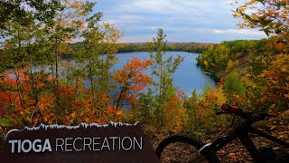
A very challenging singletrack trail with lots of red iron-rock gardens. First half of trail is tight singletrack with rock gardens abound, before opening up to a more flowy bench-cut trail with some rock armoring.

Tags

Trail Supporters

Local Trail Association

Recent Activity on Trail

Past Week
  • 0 rides
  •  
6 Months
  • 23 rides
  • 29 miles avg distance
All
  • 203 rides
  • Last: Nov 1, 2026
c1c2c3c4
January
February
March
April
May
June
July
August
September
October
November
December
update trails status or condition

Bloodstone Trail Reports

statusdatedescription
Nov 8, 2026 @ 12:54pm (America/Chicago)
Nov 8, 2026
Nov 21, 2023 @ 7:20am
Nov 21, 2023
Trail is clear from leaves, some soft spots from some rain today, other spots tacky.
Aug 21, 2023 @ 11:36am
Aug 21, 2023
Very dry, drop your pressures. However, rolling very fast and trails in excellent shape.
Jul 23, 2023 @ 2:57am
Jul 23, 2023
Dec 6, 2021 @ 6:26am
Dec 6, 2021
reporter 12 inches of new slow. Grooming in process. Please only bikes and snowshoes on singletrack. Haul roads open for walking.
more »
Status:
on Nov 8, 2026
Avg: 4.22 (12 votes)
Your vote: 0

view (1,387)
close
      Directions to bloodstone trailhead (47.214470, -93.607770)

      Photos

      16 more »
      mtb
      42 |
      Aug 7, 2026 @ 11:57am
      Aug 7, 2026
      mtb
      44 |
      Aug 7, 2026 @ 11:57am
      Aug 7, 2026
      mtb
      44 |
      Aug 6, 2026 @ 4:24pm
      Aug 6, 2026
      mtb
      53 |
      Aug 6, 2026 @ 4:23pm
      Aug 6, 2026

      Videos

      5 more »
      youtuber Bloodstone Trail + CRASH + PORCUPINE at Tioga...
      mtb
      17:21 | 571 | Jun 27, 2021 , Cohasset
      Flowin' Through Fall Colors at Tioga...
      mtb
      22:11 | 372 | Mar 23, 2024 , Cohasset
      youtuber Bloodstone Trail + CRASH + PORCUPINE at Tioga...
      mtb
      17:21 | 407 | Jun 27, 2021 , Cohasset
      Bloodstone MTB trail ride, Tioga mine...
      mtb
      6:47 | 662 | Apr 27, 2021 , Cohasset

      Routes with this trail

      more »
      13 miles • 1,353 ft • 14 •
      The ride I plan to ride when I go to ride Tioga today
      4.4 ★★★★★
      12 Ratings
      5 ★ 58%
      4 ★ 17%
      3 ★ 25%
      2 ★
      1 ★

      6 Reviews & Comments

      superacingurl superacingurl
      KEEP THIS ALIVE!!!! The network needs more like this please and thanks :-)
      amhMN
      Challenging tech trail marked with lots of rock armor from mine tailings reminiscent of Rock Solid trail contracting’s work.

      Note: As of June 2025 the trail direction shown is incorrect. Descent primary trail that finishes at Hub 2.
      superacingurl superacingurl
      Thank you for making a sweet tech trail! Not a true double black though I'd say as a pro xc mtb athlete this rides on maybe the gnarlier side of black in a few spots, but nothing you can't get off and walk or stop to see and try! Amazing work.

      We hope you've been enjoying Trailforks!

      Create a FREE account to view all trail reviews and much more.

      • By qualitybarnbroTF Pro & contributors
      • #212069 - 2,804 views

      Frequently Asked Questions

      ▼ Where is Bloodstone located?
      Bloodstone is located in Tioga Recreation Area, Cohasset, Minnesota, United States. It is part of the Tioga Recreation Area trail network. The trailhead is located at coordinates 47.21447, -93.60777.
      ▼ How hard is Bloodstone?
      Bloodstone is rated as Double Black Diamond difficulty. The physical rating is Hard. The average grade is 0.9%. The climb difficulty is rated Black Diamond.
      ▼ What is the elevation gain for Bloodstone?
      Bloodstone has 113 ft of elevation gain. The trail has 171 ft of elevation descent. The elevation ranges from 1,316 ft to 1,398 ft.
      ▼ How long is Bloodstone?
      Bloodstone is 1.3 miles long. The trail type is singletrack.
      ▼ Are dogs allowed on Bloodstone?
      Yes, dogs are allowed on Bloodstone. Please keep dogs on a leash where required and clean up after them.
      ▼ When is the best time of year to ride Bloodstone?
      Based on activity log data, the most popular months to ride Bloodstone are:
      • August (15 activities)
      • June (14 activities)
      • July (14 activities)
      Check the reports page for current trail conditions.
      ▼ How do I access Bloodstone? Where is the closest parking trailhead?
      The closest parking and trailhead locations to Bloodstone are: View all parking locations in the area.
      ▼ How long does it take to ride Bloodstone?
      Based on recorded activities, it takes an average of 8 minutes to ride Bloodstone. The trail is 1.3 miles long. Actual times will vary based on fitness level, conditions, and pace. View recent activity logs for more details.
      ▼ How busy is Bloodstone?
      Bloodstone is a less popular trail with lighter traffic. There have been 911 recorded activities on this trail. The trail has received 1,387 check-ins. View recent activity on this trail.

      Hit the Trail

      Open in App

      Get this trail on your phone instantly.

      open trail in app

      Download Trail

      Save to wishlist, Garmin & download.
      save the trail

      Find Related Routes

      Find routes and users activities that include this trail.
      find routes for this trail

      You must enter a description before submitting.