

more stats
1.9 miles
Distance
-1,337 ft
Descent
00:06:44
Avg time
-1,337 ft
Altitude change
3,452 ft
Altitude min
4,792 ft
Altitude max
4,789 ft
Altitude start
3,451 ft
Altitude end
-13.6%
Grade
-73.9%
Grade max
-1.2%
Grade min
30 ft
Distance climb
2 miles
Distance down
00:06:44
Avg time

BLUE Line Details

  • Activities
    • Mountain Bike
    • E-Bike
  • Riding Area
    Bike-Circus - Saalbach Hinterglemm
    Saalbach Hinterglemm
  • Ref Number
    SH07
  • Difficulty Rating
  • Voted Difficulty
    Green (5 votes)
  • Local Popularity
    45 in Mountain Biking [+]
    • 10 in E-Biking
  • Global Ranking
    #106374 in Mountain Biking [+]
    • #118061 in E-Biking
  • National Ranking
    #665 in Mountain Biking · Austria [+]
    • #541 in E-Biking
  • Trail Type
    Machine Groomed
  • Bike Type
    DH, AM
  • Direction
    Downhill Only
    Popular Direction Shown
  • Dogs Allowed
    Yes
  • eBike Allowed
    Yes up to Class 1
  • TTFs on Trail
    Bridge, Jump
  • Land Owner

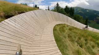
The relatively easy BLUE Line on the Reiterkogel is right next to the PRO Line. It is designed more with beginners in mind, and is one of the more beginner-friendly trails in Saalbach Hinterglemm, but thanks to its flow, it’s also great for experienced bikers. The BLUE Line offers easy, steep bends, small jumps, and flat Northshore elements and has wonderful views of the Glemmtal mountains.

Many get their first taste of freeriding here, though despite its categorization as an “easy freeride” trail, the BLUE Line still is and remains a freeride trail, and as such some passages require a certain degree of bike control, and you should be wearing the relevant protection.

Tags
BridgesJumpsViewsWooden features

Bike Park

Recent Activity on Trail

Past Week
  • 0 rides
  •  
6 Months
  • 0 rides
  •  
All
  • 311 rides
  • Last: Aug 17, 2014
c1c2c3c4
January
February
March
April
May
June
July
August
September
October
November
December
update trails status or condition

BLUE Line Trail Reports

Status:
on Aug 5, 2026
Avg: 3.58 (47 votes)
Your vote: 0

view (3,705)
close
      Directions to blue-line trailhead (47.388780, 12.590280)

      Photos

      20 more »
      mtb
      349 |
      Nov 20, 2015 @ 4:22am
      Nov 20, 2015
      mtb
      310 |
      Nov 20, 2015 @ 4:19am
      Nov 20, 2015
      mtb
      330 |
      Nov 20, 2015 @ 4:20am
      Nov 20, 2015
      mtb
      304 |
      Oct 30, 2015 @ 11:56am
      Oct 30, 2015

      Videos

      29 more »
      youtuber Blue Line | SH07 - Bike Circus Saalbach...
      mtb
      5:35 | 170 | Jun 24, 2026 , Saalbach Hinterglemm
      BLUE LINE in Saalbach-Hinterglemm 2025. Trails...
      mtb
      8:01 | 196 | Aug 16, 2025 , Saalbach Hinterglemm
      Saalbach | Blueline | 2020
      mtb
      3:59 | 79 | Jan 18, 2025 , Saalbach Hinterglemm
      Saalbach Bikepark - Blue-Line
      mtb
      7:27 | 43 | Nov 8, 2024 , Saalbach Hinterglemm

      Trail Lists

      Routes with this trail

      ★ 2.0 • 57 miles • 16,295 ft • 12 • Loop •
      „THE CHALLENGE – Bike your limit“ heißt die neue Herausforderung in Österreichs größter...
      3.5 ★★★★★
      47 Ratings
      5 ★ 13%
      4 ★ 45%
      3 ★ 30%
      2 ★ 6%
      1 ★ 6%

      2 Reviews & Comments

      Roar-Roar
      Lots of big wooden features accessible to beginners. Very fun blue trail.

      We hope you've been enjoying Trailforks!

      Create a FREE account to view all trail reviews and much more.

      Frequently Asked Questions

      ▼ Where is BLUE Line located?
      BLUE Line is located in Bike-Circus - Saalbach Hinterglemm, Saalbach Hinterglemm, Austria. It is part of the Bike-Circus - Saalbach Hinterglemm trail network. The trailhead is located at coordinates 47.38878, 12.59028.
      ▼ How hard is BLUE Line?
      BLUE Line is rated as Blue difficulty. The average grade is 13.6%.
      ▼ What is the elevation gain for BLUE Line?
      The trail has 1,337 ft of elevation descent. The elevation ranges from 3,452 ft to 4,792 ft.
      ▼ Is BLUE Line a point to point trail?
      Yes, BLUE Line is a point to point trail. The direction is Downhill Only. The trail type is machine groomed.
      ▼ How long is BLUE Line?
      BLUE Line is 1.9 miles long. The trail type is machine groomed.
      ▼ Are dogs allowed on BLUE Line?
      Yes, dogs are allowed on BLUE Line. Please keep dogs on a leash where required and clean up after them.
      ▼ How long does it take to ride BLUE Line?
      Based on recorded activities, it takes an average of 7 minutes to ride BLUE Line. The trail is 1.9 miles long. Actual times will vary based on fitness level, conditions, and pace. View recent activity logs for more details.
      ▼ How busy is BLUE Line?
      BLUE Line is a moderately popular trail. There have been 2,782 recorded activities on this trail. The trail has received 3,705 check-ins. View recent activity on this trail.

      Hit the Trail

      Open in App

      Get this trail on your phone instantly.

      open trail in app

      Download Trail

      Save to wishlist, Garmin & download.
      save the trail

      Find Related Routes

      Find routes and users activities that include this trail.
      find routes for this trail

      You must enter a description before submitting.


