more stats
1.1 miles
Distance
2 ft
Climb
-1,111 ft
Descent
00:13:00
Avg time
-1,108 ft
Altitude change
3,656 ft
Altitude min
4,764 ft
Altitude max
4,764 ft
Altitude start
3,655 ft
Altitude end
-19.7%
Grade
-54.8%
Grade max
0.6%
Grade min
52 ft
Distance climb
1 mile
Distance down
92 ft
Distance flat
00:13:00
Avg time

PRO Line Details

  • Activities
    • Mountain Bike
    • E-Bike
  • Riding Area
    Bike-Circus - Saalbach Hinterglemm
    Saalbach Hinterglemm
  • Ref Number
    SH42
  • Difficulty Rating
  • Voted Difficulty
    Red (10 votes)
  • Local Popularity
    60 in Mountain Biking [+]
    • 40 in E-Biking
  • Global Ranking
    #26798 in Mountain Biking [+]
    • #82403 in E-Biking
  • Trail Type
    Singletrack
  • Bike Type
    DH
  • Direction
    Downhill Only
    Popular Direction Shown
  • Trail Visibility
    Always easy to follow
  • Dogs Allowed
    Yes
  • eBike Allowed
    Yes up to Class 1
  • TTFs on Trail
    Drop, Jump
  • Land Owner

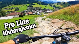
The PRO Line on the Reiterkogel is characterized at the beginning by narrow forest paths, followed by rocky sections and lots of North Shore variations. Berms, doubles, tables, drops, technical route passages, and lots of smaller jumps make the PRO Line packed full of fun and action. The upper section is somewhat more technical, whereas in the lower section, there are wider bends with nice berms which you can take with more speed.

At various points, the Evil Eye Trail branches off from the PRO Line, making all sorts of variations possible. These sections are characterized by North Shore elements and high drops. To take on the Evil Eye Trail you must be good in your biking technique and have plenty of experience. This is why these trails are “for pros only”

Bike Park

Recent Activity on Trail

Past Week
  • 0 rides
  •  
6 Months
  • 0 rides
  •  
All
  • 157 rides
  • Last: Oct 23, 2025
c1c2c3c4
January
February
March
April
May
June
July
August
September
October
November
December
update trails status or condition

PRO Line Trail Reports

statusdatedescription
Sep 11, 2025 @ 9:59am
Sep 11, 2025
Aug 2, 2024 @ 1:22am
Aug 2, 2024
Oct 1, 2023 @ 12:05am
Oct 1, 2023
Sep 23, 2023 @ 5:45am
Sep 23, 2023
Aug 31, 2023 @ 6:27am
Aug 31, 2023
The Pro line is mostly dry but after the Drops the Trail is closed due to maintance wich means you have to climb over a fence and then ride on the...
more »
Status:
on Sep 11, 2025
Ideal
Avg: 4.49 (34 votes)
Your vote: 0

view (2,396)
close
3D
Trail Conditions
  • Unknown
  • Snow Groomed
  • Snow Packed
  • Snow Covered
  • Snow Cover Partial
  • Freeze/thaw Cycle
  • Icy
  • Prevalent Mud
  • Wet
  • Variable
  • Ideal
  • Dry
  • Very Dry
Trail Flow (Ridden Direction)
Trailforks scans users ridelogs to determine the most popular direction each trail is ridden. A good flowing trail network will have most trails flowing in a single direction according to their intension.
The colour categories are based on what percentage of riders are riding a trail in its intended direction.
  • > 96%
  • > 90%
  • > 80%
  • > 70%
  • > 50%
  • < 50%
  • bi-directional trail
  • no data
Trail Last Ridden
Trailforks scans ridelogs to determine the last time a trail was ridden.
  • < 2 days
  • < 1 week
  • < 2 weeks
  • < 1 month
  • < 6 months
  • > 6 months
Trail Ridden Direction
The intended direction a trail should be ridden.
  • Downhill Only
  • Downhill Primary
  • Both Directions
  • Uphill Primary
  • Uphill Only
  • One Direction
Contribute Details
Colors indicate trail is missing specified detail.
  • Description
  • Photos
  • Description & Photos
  • Videos
Trail Popularity ?
Trailforks scans ridelogs to determine which trails are ridden the most in the last 9 months. Trails are compared with nearby trails in the same city region with a possible 25 colour shades. Think of this as a heatmap, more rides = more kinetic energy = warmer colors.
  • most popular
  • popular
  • less popular
  • not popular
ATV/ORV/OHV Filter
Max Vehicle Width
inches
US Cell Coverage
Legend
cell carrier legend

Radar Time
Activity Recordings
Trailforks uses anonymized public activity data. ?
Activity Recordings
Trailforks uses anonymized public activity data. ?
Personal Heatmap
Activity Types
all / none
Options
2
Date range month
Winter Trails
Warning A routing network for winter maps does not exist. Selecting trails using the winter trails layer has been disabled.
Missing Trails
Most Popular
Least Popular
Trails are colored based on popularity. The more popular a trail is, the more red. Less popular trails trend towards green.
Jump Magnitude Heatmap
Heatmap of where riders jump on trails. Zoom in to see individual jumps, click circles to view jump details.
BC Backroad Status

Service Road Atlas is a free to use, community-driven service for viewing and creating reports on the numerous back-country service roads around B.C. and Alberta.

map legend
Slope Aspect
Direction the slope faces
Flat N NE E SE S SW W NW
Trails Deemphasized
Trails are shown in grey.
disable
Only show trails with no bike usage.
Enable
Suggested Layers
Based on selected activity type

    Save the current map location and zoom level as your default home location whenever this page is loaded.

    Save
        Directions to pro-line trailhead (47.389210, 12.591670)

        Photos

        60 more »
        405 |
        Jul 19, 2016 @ 12:44am
        Jul 19, 2016
        817 |
        Oct 21, 2014 @ 1:41pm
        Oct 21, 2014
        316 |
        Oct 4, 2018 @ 12:07am
        Oct 4, 2018
        126 |
        Jun 21, 2017 @ 3:50pm
        Jun 21, 2017

        Videos

        36 more »
        PRO LINE в Saalbach-Hinterglemm!
        6:22 | 97 | May 6, 2025 , Saalbach Hinterglemm
        youtuber RIPPING Down PRO LINE and EVIL EYE TRAIL |...
        13:37 | 269 | Dec 18, 2022 , Saalbach Hinterglemm
        youtuber Riding Austrian Mountains In The Rain!
        16:05 | 136 | Aug 17, 2022 , Saalbach Hinterglemm
        PRO LINE - like a first time.
        6:03 | 152 | Jul 18, 2019 , Saalbach Hinterglemm

        Articles

        Video: Fabio Wibmer Smashes 'Pro Line' in Saalbach on his DH Bike
        Nov 6, 2019 from pinkbike.com
        Just as fun watching Fabio ride the big bike.

        Trail Lists

        3 Reviews & Comments


        We hope you've been enjoying Trailforks!

        Create a FREE account to view trail comments and much more.

        Frequently Asked Questions About PRO Line

        Where is PRO Line located?
        PRO Line is located in Bike-Circus - Saalbach Hinterglemm, Saalbach Hinterglemm, Austria. It is part of the Bike-Circus - Saalbach Hinterglemm trail network. The trailhead is located at coordinates 47.38921, 12.59167.
        How hard is PRO Line?
        PRO Line is rated as Red difficulty. The average grade is 19.7%.
        What is the elevation gain for PRO Line?
        PRO Line has 1 m of elevation gain. The trail has 339 m of elevation descent. The elevation ranges from 1,114 m to 1,452 m.
        Is PRO Line a point to point trail?
        Yes, PRO Line is a point to point trail. The direction is Downhill Only. The trail type is singletrack.

        Hit the Trail

        Open in App

        Get this trail on your phone instantly.
        open trail in app

        Download Trail

        Save to wishlist, Garmin & download.
        save the trail

        Find Related Routes

        Find routes and users activities that include this trail.
        find routes for this trail

        You must enter a description before submitting.