more stats
5,212 ft
Distance
154 ft
Climb
-506 ft
Descent
00:08:25
Avg time
-352 ft
Altitude change
54 ft
Altitude min
470 ft
Altitude max
470 ft
Altitude start
118 ft
Altitude end
-6.748%
Grade
-37.979%
Grade max
25.26%
Grade min
1,228 ft
Distance climb
3,430 ft
Distance down
555 ft
Distance flat
00:08:25
Avg time

Boiler Details

  • Activities
    • Mountain Bike
    • Hike
    • Trail Running
  • Riding Area
    Jackson Demonstration State Forest
    Mendocino, California
  • Difficulty Rating
  • Local Popularity
    95 in Mountain Biking [+]
    • 85 in Trail Running
    • 95 in Hiking
  • Global Ranking
    #36843 in Mountain Biking [+]
    • #35437 in Trail Running
    • #81732 in Hiking
  • Trail Type
    Singletrack
  • Bike Type
    AM, XC
  • Direction
    Downhill Primary
    Popular Direction Shown
  • Physical Rating
    Moderate
  • Season
    Year round, best in Spring and Fall.
  • Dogs Allowed
    Yes
  • Land Owner
    Jackson Demonstration State Forest

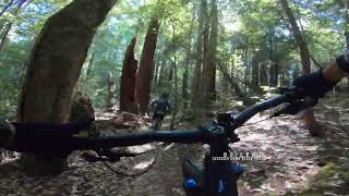
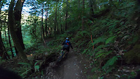
This is a very old trail that was put in by the CCC in the 1930's and leads to the Woodlands state park. For many years it was ignored and became over grown and impassable. It gets its name from the old steam boiler left there by the logging industry. The lower part of the trail used to be a logging rail road track. Now with the work by the Mendocino Coast Cyclist and the cooperation of Cal Fire and Cal State parks the trail is one of the most popular in the area. It is very rideable in both directions.Just recently a a very nice redwood bench was put in next to the boiler.where you can stop for a rest and snack.

Local Trail Association
Traditionally Indigenous Territory

Recent Activity on Trail

Past Week
  • 3 rides
  • 15 miles average
6 Months
  • 40 rides
  • 17 miles avg distance
All
  • 518 rides
  • Last: Jun 26, 2026
c1c2c3c4
January
February
March
April
May
June
July
August
September
October
November
December
update trails status or condition

Boiler Trail Reports

Status:
on Apr 19, 2026
Ideal
Avg: 4.41 (16 votes)
Your vote: 0

view (2,778)
close
3D
Trail Conditions
  • Unknown
  • Snow Groomed
  • Snow Packed
  • Snow Covered
  • Snow Cover Partial
  • Freeze/thaw Cycle
  • Icy
  • Prevalent Mud
  • Wet
  • Variable
  • Ideal
  • Dry
  • Very Dry
Trail Flow (Ridden Direction)
Trailforks scans users ridelogs to determine the most popular direction each trail is ridden. A good flowing trail network will have most trails flowing in a single direction according to their intension.
The colour categories are based on what percentage of riders are riding a trail in its intended direction.
  • > 96%
  • > 90%
  • > 80%
  • > 70%
  • > 50%
  • < 50%
  • bi-directional trail
  • no data
Trail Last Ridden
Trailforks scans ridelogs to determine the last time a trail was ridden.
  • < 2 days
  • < 1 week
  • < 2 weeks
  • < 1 month
  • < 6 months
  • > 6 months
Trail Ridden Direction
The intended direction a trail should be ridden.
  • Downhill Only
  • Downhill Primary
  • Both Directions
  • Uphill Primary
  • Uphill Only
  • One Direction
Contribute Details
Colors indicate trail is missing specified detail.
  • Description
  • Photos
  • Description & Photos
  • Videos
Trail Popularity ?
Trailforks scans ridelogs to determine which trails are ridden the most in the last 9 months. Trails are compared with nearby trails in the same city region with a possible 25 colour shades. Think of this as a heatmap, more rides = more kinetic energy = warmer colors.
  • most popular
  • popular
  • less popular
  • not popular
ATV/ORV/OHV Filter
Max Vehicle Width
inches
US Cell Coverage
Legend
cell carrier legend

Radar Time
Activity Recordings
Trailforks uses anonymized public activity data. ?
Activity Recordings
Trailforks uses anonymized public activity data. ?
Personal Heatmap
Activity Types
all / none
Options
2
Date range month
Winter Trails
Warning A routing network for winter maps does not exist. Selecting trails using the winter trails layer has been disabled.
Missing Trails
Most Popular
Least Popular
Trails are colored based on popularity. The more popular a trail is, the more red. Less popular trails trend towards green.
Jump Magnitude Heatmap
Heatmap of where riders jump on trails. Zoom in to see individual jumps, click circles to view jump details.
BC Backroad Status

Service Road Atlas is a free to use, community-driven service for viewing and creating reports on the numerous back-country service roads around B.C. and Alberta.

map legend
Slope Aspect
Direction the slope faces
Flat N NE E SE S SW W NW
Trails Deemphasized
Trails are shown in grey.
disable
Only show trails with no bike usage.
Enable
Suggested Layers
Based on selected activity type

    Save the current map location and zoom level as your default home location whenever this page is loaded.

    Save
        Directions to boiler trailhead (39.316188, -123.718221)

        Photos

        21 more »
        82 |
        Jun 2, 2025 @ 8:29pm
        Jun 2, 2025
        81 |
        Jun 2, 2025 @ 8:29pm
        Jun 2, 2025
        68 |
        Jun 2, 2025 @ 8:29pm
        Jun 2, 2025
        93 |
        Jan 1, 2024 @ 4:24pm
        Jan 1, 2024

        Videos

        3 more »
        Boiler Trail  - Jackson Demonstration State Forest
        5:07 | 104 | Oct 25, 2024 , Mendocino
        Endo O-No Fury III Boiler Trail Guide
        12:11 | 449 | Sep 19, 2020 , Mendocino
        Good Brakes
        0:07 | 131 | Feb 26, 2022 , Mendocino

        Routes with this trail

        5.0 19 miles 3,127 ft 13 Loop
        This route includes most of our favorite trails in this area and almost completely avoids fire roads. It's...
        5.0 26 miles 4,331 ft 26
        This is a route loosely based off of a prior enduro.
        3.0 7 miles 914 ft 4 Shuttled
        This route skips the ride up to save emtb/onewheel battery for the rest of the route. Ends near heartwood...

        5 Reviews & Comments


        We hope you've been enjoying Trailforks!

        Create a FREE account to view trail comments and much more.

        • By FRguild & contributors
        • #23660 - 3,936 views

        Frequently Asked Questions About Boiler

        Where is Boiler located?
        Boiler is located in Jackson Demonstration State Forest, Mendocino, California, United States. It is part of the Jackson Demonstration State Forest trail network. The trailhead is located at coordinates 39.31619, -123.71822.
        How hard is Boiler?
        Boiler is rated as Blue difficulty. The physical rating is Moderate. The average grade is 6.748%.
        What is the elevation gain for Boiler?
        Boiler has 154 ft of elevation gain. The trail has 506 ft of elevation descent. The elevation ranges from 54 ft to 470 ft.
        Is Boiler a point to point trail?
        Boiler is not a point to point trail. The direction is Downhill Primary. The trail type is singletrack.

        Hit the Trail

        Open in App

        Get this trail on your phone instantly.
        open trail in app

        Download Trail

        Save to wishlist, Garmin & download.
        save the trail

        Find Related Routes

        Find routes and users activities that include this trail.
        find routes for this trail

        You must enter a description before submitting.