more stats
462 ft
Distance
-52 ft
Descent
00:02:06
Avg time
-53 ft
Altitude change
393 ft
Altitude min
446 ft
Altitude max
446 ft
Altitude start
393 ft
Altitude end
-11.579%
Grade
-29.309%
Grade max
38 ft
Distance climb
389 ft
Distance down
36 ft
Distance flat
00:02:06
Avg time

Bootleg Details

  • Activities
    • Mountain Bike
    • Hike
    • Trail Running
  • Riding Area
    Centennial Reserve
    Wellington
  • Difficulty Rating
  • Voted Difficulty
    Blue (1 vote)
  • Local Popularity
    75 in Mountain Biking [+]
    • 70 in Trail Running
    • 95 in Hiking
  • Global Ranking
    #32209 in Mountain Biking [+]
    • #73116 in Trail Running
    • #6368 in Hiking
  • Trail Type
    Singletrack
  • Bike Type
    XC
  • Direction
    Uphill Primary
    Popular Direction Shown
  • Climb Difficulty
    Blue
  • Physical Rating
    Easy
  • Dogs Allowed
    Yes
  • TTFs on Trail
    Bridge
  • Year Opened
    2009

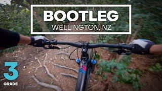
Bootleg has mainly been replaced by Jvenile creating a loop for the kids and newbies.
One section still exists instead of doing the dual slalom. Watch the tree drop just after the start on the first left hander

source: Bootleg
Access Info

The eastern end is on Nevay Road, just up hill of the last bus shelter before the prison.

The western end is to the right of the prison sign on Main Road, just outside where the road to the water tanks is obstructed by several concrete blocks. Head towards the water tanks to find the top of Jail Brake.

Local Trail Association

Recent Activity on Trail

Past Week
  • 2 rides
  • 13.0 km average
6 Months
  • 18 rides
  • 9.8 km avg distance
All
  • 320 rides
  • Last: Jun 3, 2026
c1c2c3c4
January
February
March
April
May
June
July
August
September
October
November
December
Status:
on May 28, 2026
Ideal
Avg: 3.89 (4 votes)
Your vote: 0

view (9,033)
close
3D
Trail Conditions
  • Unknown
  • Snow Groomed
  • Snow Packed
  • Snow Covered
  • Snow Cover Partial
  • Freeze/thaw Cycle
  • Icy
  • Prevalent Mud
  • Wet
  • Variable
  • Ideal
  • Dry
  • Very Dry
Trail Flow (Ridden Direction)
Trailforks scans users ridelogs to determine the most popular direction each trail is ridden. A good flowing trail network will have most trails flowing in a single direction according to their intension.
The colour categories are based on what percentage of riders are riding a trail in its intended direction.
  • > 96%
  • > 90%
  • > 80%
  • > 70%
  • > 50%
  • < 50%
  • bi-directional trail
  • no data
Trail Last Ridden
Trailforks scans ridelogs to determine the last time a trail was ridden.
  • < 2 days
  • < 1 week
  • < 2 weeks
  • < 1 month
  • < 6 months
  • > 6 months
Trail Ridden Direction
The intended direction a trail should be ridden.
  • Downhill Only
  • Downhill Primary
  • Both Directions
  • Uphill Primary
  • Uphill Only
  • One Direction
Contribute Details
Colors indicate trail is missing specified detail.
  • Description
  • Photos
  • Description & Photos
  • Videos
Trail Popularity ?
Trailforks scans ridelogs to determine which trails are ridden the most in the last 9 months. Trails are compared with nearby trails in the same city region with a possible 25 colour shades. Think of this as a heatmap, more rides = more kinetic energy = warmer colors.
  • most popular
  • popular
  • less popular
  • not popular
ATV/ORV/OHV Filter
Max Vehicle Width
inches
US Cell Coverage
Legend
cell carrier legend

Radar Time
Activity Recordings
Trailforks uses anonymized public activity data. ?
Activity Recordings
Trailforks uses anonymized public activity data. ?
Personal Heatmap
Activity Types
all / none
Options
2
Date range month
Winter Trails
Warning A routing network for winter maps does not exist. Selecting trails using the winter trails layer has been disabled.
Missing Trails
Most Popular
Least Popular
Trails are colored based on popularity. The more popular a trail is, the more red. Less popular trails trend towards green.
Jump Magnitude Heatmap
Heatmap of where riders jump on trails. Zoom in to see individual jumps, click circles to view jump details.
BC Backroad Status

Service Road Atlas is a free to use, community-driven service for viewing and creating reports on the numerous back-country service roads around B.C. and Alberta.

map legend
Slope Aspect
Direction the slope faces
Flat N NE E SE S SW W NW
Trails Deemphasized
Trails are shown in grey.
disable
Only show trails with no bike usage.
Enable
Suggested Layers
Based on selected activity type

    Save the current map location and zoom level as your default home location whenever this page is loaded.

    Save
        Directions to bootleg trailhead (-41.297610, 174.826640)

        Photos

        1 more »
        325 |
        Oct 6, 2015 @ 7:48pm
        Oct 6, 2015

        Videos

        3 more »
        youtuber INTRO TO TECH - Bootleg Mountain Bike Trail...
        0:55 | 371 | Sep 26, 2020 , Wellington
        BOOTLEG in MIRAMAR | MYRIDE WELLINGTON TRAILVIEW
        0:52 | 307 | May 5, 2020 , Wellington
        MTB Bootleg Feb 2011
        0:01 | 320 | Jul 15, 2018 , Wellington

        Routes with this trail

        1 mile 324 ft 4 Loop
        good quick loop in Miramar wellington

        Reviews / Comments

        No reviews yet, be the first to write a review or ask a question.
        Use trail reports to comment on trail conditions.


        We hope you've been enjoying Trailforks!

        Create a FREE account to view trail comments and much more.

        • By Wrattler & contributors
        • #18973 - 3,909 views

        Frequently Asked Questions About Bootleg

        Where is Bootleg located?
        Bootleg is located in Centennial Reserve, Wellington, New Zealand. It is part of the Centennial Reserve trail network. The trailhead is located at coordinates -41.29761, 174.82664.
        How hard is Bootleg?
        Bootleg is rated as Blue difficulty. The physical rating is Easy. The average grade is 11.579%. The climb difficulty is rated Blue.
        What is the elevation gain for Bootleg?
        The trail has 52 ft of elevation descent. The elevation ranges from 393 ft to 446 ft.
        Is Bootleg a point to point trail?
        Bootleg is not a point to point trail. The direction is Uphill Primary. The trail type is singletrack.

        Hit the Trail

        Open in App

        Get this trail on your phone instantly.
        open trail in app

        Download Trail

        Save to wishlist, Garmin & download.
        save the trail

        Find Related Routes

        Find routes and users activities that include this trail.
        find routes for this trail

        You must enter a description before submitting.