more stats
1,102 ft
Distance
20 ft
Climb
-54 ft
Descent
00:01:53
Avg time
-35 ft
Altitude change
321 ft
Altitude min
379 ft
Altitude max
357 ft
Altitude start
322 ft
Altitude end
-3.2%
Grade
-23.6%
Grade max
14.7%
Grade min
249 ft
Distance climb
827 ft
Distance down
26 ft
Distance flat
00:01:53
Avg time

Party Down Details

  • Activities
    • Mountain Bike
    • E-Bike
    • Winter Fat Bike
  • Riding Area
    Don Valley
    Toronto, Ontario
  • Difficulty Rating
  • Voted Difficulty
    Black Diamond (4 votes)
  • Local Popularity
    95 in Mountain Biking [+]
    • 95 in E-Biking
  • Global Ranking
    #9005 in Mountain Biking [+]
    • #17058 in E-Biking
  • Trail Type
    Singletrack
  • Bike Type
    AM, XC, Fat
  • Direction
    Downhill Only
    Popular Direction Shown
  • Trail Visibility
    Always easy to follow
  • Dogs Allowed
    Yes
  • eBike Allowed
  • TTFs on Trail
    Berm, Drop, Jump, Teeter Totter, Wallride
  • Land Owner
    City of Toronto / Toronto Region Conservation Authority

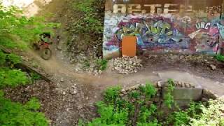
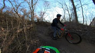
Downhill flowy goodness with some of the best berms in the city. A great way to cap off a run through Catalyst and Party Atmosphere.

The new name, supported by the builders of this trail, refers to this trail being the de-facto downhill ending of Party Atmosphere.

This trail is unsanctioned.

Recent Activity on Trail

Past Week
  • 0 rides
  •  
6 Months
  • 20 rides
  • 17 miles avg distance
All
  • 2,584 rides
  • Last: Jun 16, 2026
c1c2c3c4
January
February
March
April
May
June
July
August
September
October
November
December
update trails status or condition

Party Down Trail Reports

Status:
on Jun 7, 2026
Ideal
Avg: 4.3 (24 votes)
Your vote: 0

view (13,797)
close
3D
Trail Conditions
  • Unknown
  • Snow Groomed
  • Snow Packed
  • Snow Covered
  • Snow Cover Partial
  • Freeze/thaw Cycle
  • Icy
  • Prevalent Mud
  • Wet
  • Variable
  • Ideal
  • Dry
  • Very Dry
Trail Flow (Ridden Direction)
Trailforks scans users ridelogs to determine the most popular direction each trail is ridden. A good flowing trail network will have most trails flowing in a single direction according to their intension.
The colour categories are based on what percentage of riders are riding a trail in its intended direction.
  • > 96%
  • > 90%
  • > 80%
  • > 70%
  • > 50%
  • < 50%
  • bi-directional trail
  • no data
Trail Last Ridden
Trailforks scans ridelogs to determine the last time a trail was ridden.
  • < 2 days
  • < 1 week
  • < 2 weeks
  • < 1 month
  • < 6 months
  • > 6 months
Trail Ridden Direction
The intended direction a trail should be ridden.
  • Downhill Only
  • Downhill Primary
  • Both Directions
  • Uphill Primary
  • Uphill Only
  • One Direction
Contribute Details
Colors indicate trail is missing specified detail.
  • Description
  • Photos
  • Description & Photos
  • Videos
Trail Popularity ?
Trailforks scans ridelogs to determine which trails are ridden the most in the last 9 months. Trails are compared with nearby trails in the same city region with a possible 25 colour shades. Think of this as a heatmap, more rides = more kinetic energy = warmer colors.
  • most popular
  • popular
  • less popular
  • not popular
ATV/ORV/OHV Filter
Max Vehicle Width
inches
US Cell Coverage
Legend
cell carrier legend

Radar Time
Activity Recordings
Trailforks uses anonymized public activity data. ?
Activity Recordings
Trailforks uses anonymized public activity data. ?
Personal Heatmap
Activity Types
all / none
Options
2
Date range month
Winter Trails
Warning A routing network for winter maps does not exist. Selecting trails using the winter trails layer has been disabled.
Missing Trails
Most Popular
Least Popular
Trails are colored based on popularity. The more popular a trail is, the more red. Less popular trails trend towards green.
Jump Magnitude Heatmap
Heatmap of where riders jump on trails. Zoom in to see individual jumps, click circles to view jump details.
BC Backroad Status

Service Road Atlas is a free to use, community-driven service for viewing and creating reports on the numerous back-country service roads around B.C. and Alberta.

map legend
Slope Aspect
Direction the slope faces
Flat N NE E SE S SW W NW
Trails Deemphasized
Trails are shown in grey.
disable
Only show trails with no bike usage.
Enable
Suggested Layers
Based on selected activity type

    Save the current map location and zoom level as your default home location whenever this page is loaded.

    Save
        Directions to party-down trailhead (43.714800, -79.347390)

        Photos

        14 more »
        978 |
        Sep 9, 2017 @ 5:46pm
        Sep 9, 2017
        219 |
        Nov 6, 2021 @ 3:47pm
        Nov 6, 2021
        280 |
        Nov 6, 2021 @ 3:47pm
        Nov 6, 2021
        344 |
        Oct 31, 2020 @ 2:50pm
        Oct 31, 2020

        Videos

        3 more »
        youtuber Don Valley Mountain Bike Trail Riding: Party...
        2:40 | 1526 | Jun 8, 2020 , Toronto
        Don Valley - Rolling Topo to BOT with the...
        179 | May 23, 2022 , Toronto
        YouTube
        18:21 | 643 | Jun 15, 2020 , Toronto

        Trail Lists

        Routes with this trail

        5.0 59 miles 5,018 ft 111 Loop
        100k loop through the greater Valley, the route has almost no repeat sections. Consists mostly of...
        2.0 50 miles 3,912 ft 414 Loop
        An extremely physical loop connecting together every trail in the Valley Completionist Badge. A good and...
        18 miles 1,700 ft 41 Loop
        This is an around the Valley ride on as many of the harder/exciting trails. High level of fitness &...

        13 Reviews & Comments


        We hope you've been enjoying Trailforks!

        Create a FREE account to view trail comments and much more.

        Nearby Trails

        • #42382 - 9,917 views

        Frequently Asked Questions About Party Down

        Where is Party Down located?
        Party Down is located in Don Valley, Toronto, Ontario, Canada. It is part of the Don Valley trail network. The trailhead is located at coordinates 43.7148, -79.34739.
        How hard is Party Down?
        Party Down is rated as Double Black Diamond difficulty. The average grade is 3.2%.
        What is the elevation gain for Party Down?
        Party Down has 20 ft of elevation gain. The trail has 54 ft of elevation descent. The elevation ranges from 321 ft to 379 ft.
        Is Party Down a point to point trail?
        Yes, Party Down is a point to point trail. The direction is Downhill Only. The trail type is singletrack.

        Hit the Trail

        Open in App

        Get this trail on your phone instantly.
        open trail in app

        Download Trail

        Save to wishlist, Garmin & download.
        save the trail

        Find Related Routes

        Find routes and users activities that include this trail.
        find routes for this trail

        You must enter a description before submitting.