more stats
3,425 ft
Distance
11 ft
Climb
-185 ft
Descent
00:03:40
Avg time
-172 ft
Altitude change
2,019 ft
Altitude min
2,207 ft
Altitude max
2,206 ft
Altitude start
2,034 ft
Altitude end
-5%
Grade
-25.9%
Grade max
8.5%
Grade min
404 ft
Distance climb
2,388 ft
Distance down
591 ft
Distance flat
00:03:40
Avg time

Breakout Details

  • Activities
    • Mountain Bike
  • Riding Area
  • Difficulty Rating
  • Voted Difficulty
    Blue (1 vote)
  • Local Popularity
    85 in Mountain Biking
  • Global Ranking
    #433 in Mountain Biking
  • Trail Type
    Singletrack
  • Bike Type
    XC
  • Direction
    Downhill Only
    Popular Direction Shown
  • eBike Allowed
    Yes up to Class 1
  • Land Owner
    CMTEDD - National Arboretum Canberra/Stromlo Forest Park

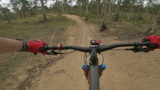
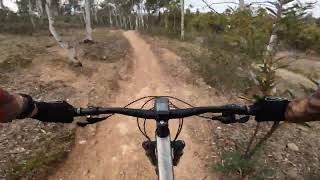
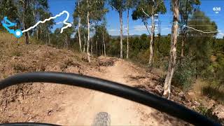
Except for the last few metres (after crossing the wooden bridge) Breakout is a descending trail. It is always a bit rough and loose with a mixture of banked and flat corners. Keep an eye out at the sides of the trail for optional jump features. A really fun trail to go fast on.

Trail Supporters

Bike Park

Local Trail Association
Traditionally Indigenous Territory

Recent Activity on Trail

Past Week
  • 9 rides
  • 10 miles average
6 Months
  • 352 rides
  • 13 miles avg distance
All
  • 3,268 rides
  • Last: Jun 24, 2026
c1c2c3c4
January
February
March
April
May
June
July
August
September
October
November
December
Status:
on May 26, 2026
Wet
Avg: 4.37 (10 votes)
Your vote: 0

view (25,358)
close
3D
Trail Conditions
  • Unknown
  • Snow Groomed
  • Snow Packed
  • Snow Covered
  • Snow Cover Partial
  • Freeze/thaw Cycle
  • Icy
  • Prevalent Mud
  • Wet
  • Variable
  • Ideal
  • Dry
  • Very Dry
Trail Flow (Ridden Direction)
Trailforks scans users ridelogs to determine the most popular direction each trail is ridden. A good flowing trail network will have most trails flowing in a single direction according to their intension.
The colour categories are based on what percentage of riders are riding a trail in its intended direction.
  • > 96%
  • > 90%
  • > 80%
  • > 70%
  • > 50%
  • < 50%
  • bi-directional trail
  • no data
Trail Last Ridden
Trailforks scans ridelogs to determine the last time a trail was ridden.
  • < 2 days
  • < 1 week
  • < 2 weeks
  • < 1 month
  • < 6 months
  • > 6 months
Trail Ridden Direction
The intended direction a trail should be ridden.
  • Downhill Only
  • Downhill Primary
  • Both Directions
  • Uphill Primary
  • Uphill Only
  • One Direction
Contribute Details
Colors indicate trail is missing specified detail.
  • Description
  • Photos
  • Description & Photos
  • Videos
Trail Popularity ?
Trailforks scans ridelogs to determine which trails are ridden the most in the last 9 months. Trails are compared with nearby trails in the same city region with a possible 25 colour shades. Think of this as a heatmap, more rides = more kinetic energy = warmer colors.
  • most popular
  • popular
  • less popular
  • not popular
ATV/ORV/OHV Filter
Max Vehicle Width
inches
US Cell Coverage
Legend
cell carrier legend

Radar Time
Activity Recordings
Trailforks uses anonymized public activity data. ?
Activity Recordings
Trailforks uses anonymized public activity data. ?
Personal Heatmap
Activity Types
all / none
Options
2
Date range month
Winter Trails
Warning A routing network for winter maps does not exist. Selecting trails using the winter trails layer has been disabled.
Missing Trails
Most Popular
Least Popular
Trails are colored based on popularity. The more popular a trail is, the more red. Less popular trails trend towards green.
Jump Magnitude Heatmap
Heatmap of where riders jump on trails. Zoom in to see individual jumps, click circles to view jump details.
BC Backroad Status

Service Road Atlas is a free to use, community-driven service for viewing and creating reports on the numerous back-country service roads around B.C. and Alberta.

map legend
Slope Aspect
Direction the slope faces
Flat N NE E SE S SW W NW
Trails Deemphasized
Trails are shown in grey.
disable
Only show trails with no bike usage.
Enable
Suggested Layers
Based on selected activity type

    Save the current map location and zoom level as your default home location whenever this page is loaded.

    Save
        Directions to breakout trailhead (-35.313480, 149.018260)

        Photos

        4 more »
        72 |
        Apr 18, 2022 @ 11:50pm
        Apr 18, 2022
        43 |
        Mar 29, 2022 @ 8:01pm
        Mar 29, 2022
        172 |
        Oct 11, 2016 @ 1:57am
        Oct 11, 2016
        281 |
        Oct 11, 2016 @ 1:57am
        Oct 11, 2016

        Videos

        5 more »
        Mount Stromlo MTB Park - Breakout
        3:09 | 144 | Aug 6, 2024 , Canberra
        Breakout // Mount Stromlo, Canberra // Australia
        2:24 | 111 | Jul 12, 2024 , Canberra
        Stromlo Bike Park  Breakout Canberra
        2:38 | 491 | May 5, 2021 , Canberra
        Stromlo Forrest - Breakout (Green)
        3:07 | 431 | Jan 9, 2021 , Canberra

        Trail Lists

        Routes with this trail

        4.7 11 miles 1,179 ft 36
        RATING – INTERMEDIATE TIME – 90 TO 120 MINUTES Loop 4 is a full lap of Stromlo Forest Park’s...
        17 miles 2,501 ft 33
        Shimano 30 Course length 27km. Climbing 800m per lap. Approximately 75% of the trails in Stromlo used or...
        1.5 12 miles 1,607 ft 27 Loop
        Longer loop with lots of fun bits. From the main carpark, take the main trunk trail to the summit before a...

        Reviews / Comments

        No reviews yet, be the first to write a review or ask a question.
        Use trail reports to comment on trail conditions.


        We hope you've been enjoying Trailforks!

        Create a FREE account to view trail comments and much more.

        • By Jake-HannahTF Pro MPTA & contributors
        • #21275 - 2,800 views

        Frequently Asked Questions About Breakout

        Where is Breakout located?
        Breakout is located in Stromlo Forest Park, Canberra, Australia. It is part of the Stromlo Forest Park trail network. The trailhead is located at coordinates -35.31348, 149.01826.
        How hard is Breakout?
        Breakout is rated as Green difficulty. The average grade is 5%.
        What is the elevation gain for Breakout?
        Breakout has 11 ft of elevation gain. The trail has 185 ft of elevation descent. The elevation ranges from 2,019 ft to 2,207 ft.
        Is Breakout a point to point trail?
        Yes, Breakout is a point to point trail. The direction is Downhill Only. The trail type is singletrack.

        Hit the Trail

        Open in App

        Get this trail on your phone instantly.
        open trail in app

        Download Trail

        Save to wishlist, Garmin & download.
        save the trail

        Find Related Routes

        Find routes and users activities that include this trail.
        find routes for this trail

        You must enter a description before submitting.