more stats
4,344 ft
Distance
4 ft
Climb
-193 ft
Descent
00:07:34
Avg time
-190 ft
Altitude change
971 ft
Altitude min
1,162 ft
Altitude max
1,162 ft
Altitude start
971 ft
Altitude end
-4.4%
Grade
-19.6%
Grade max
9.7%
Grade min
121 ft
Distance climb
3,058 ft
Distance down
1,165 ft
Distance flat
00:07:34
Avg time

Brinkmanship Details

  • Activities
    • Mountain Bike
    • E-Bike
    • Hike
    • Trail Running
    • Snowshoe
  • Riding Area
    Split Rock Wilds
    Beaver Bay, Minnesota
  • Difficulty Rating
  • Local Popularity
    45 in Mountain Biking [+]
    • 95 in E-Biking
    • 5 in Trail Running
    • 5 in Hiking
    • 5 in Snowshoeing
  • Global Ranking
    #38627 in Mountain Biking [+]
    • #68819 in E-Biking
    • #314922 in Trail Running
    • #325221 in Hiking
    • #5736 in Snowshoeing
  • Trail Type
    Singletrack
  • Bike Type
    AM, XC
  • Direction
    Both Directions
    Popular In Reverse
  • Climb Difficulty
    Blue
  • Physical Rating
    Hard
  • Trail Visibility
    Always easy to follow
  • Dogs Allowed
    Yes
  • eBike Allowed
  • TTFs on Trail
    Bridge, Rock Face, Rock Garden
  • Land Owner
    Lake County Forestry

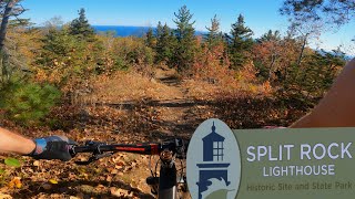
A creatively built two-way trail comprised of steeper rocky sections mixed with flatter sections of dirt allowing the rider to recover on the way up or down. Brinkmanship makes it easier to session Charlie Girl and Ope. It also allows riders to divide the trail system in half, opening up more route options. "if you are scared to go to the brink, you are lost"-JFD

Local Trail Association
Traditionally Indigenous Territory

Recent Activity on Trail

Past Week
  • 3 rides
  • 12 miles average
6 Months
  • 3 rides
  • 12 miles avg distance
All
  • 13 rides
  • Last: Jun 27, 2026
c1c2c3c4
January
February
March
April
May
June
July
August
September
October
November
December
update trails status or condition

Brinkmanship Trail Reports

Status:
on Jun 30, 2026
Wet
Avg: 4.13 (1 votes)
Your vote: 0

view (79)
close
3D
Trail Conditions
  • Unknown
  • Snow Groomed
  • Snow Packed
  • Snow Covered
  • Snow Cover Partial
  • Freeze/thaw Cycle
  • Icy
  • Prevalent Mud
  • Wet
  • Variable
  • Ideal
  • Dry
  • Very Dry
Trail Flow (Ridden Direction)
Trailforks scans users ridelogs to determine the most popular direction each trail is ridden. A good flowing trail network will have most trails flowing in a single direction according to their intension.
The colour categories are based on what percentage of riders are riding a trail in its intended direction.
  • > 96%
  • > 90%
  • > 80%
  • > 70%
  • > 50%
  • < 50%
  • bi-directional trail
  • no data
Trail Last Ridden
Trailforks scans ridelogs to determine the last time a trail was ridden.
  • < 2 days
  • < 1 week
  • < 2 weeks
  • < 1 month
  • < 6 months
  • > 6 months
Trail Ridden Direction
The intended direction a trail should be ridden.
  • Downhill Only
  • Downhill Primary
  • Both Directions
  • Uphill Primary
  • Uphill Only
  • One Direction
Contribute Details
Colors indicate trail is missing specified detail.
  • Description
  • Photos
  • Description & Photos
  • Videos
Trail Popularity ?
Trailforks scans ridelogs to determine which trails are ridden the most in the last 9 months. Trails are compared with nearby trails in the same city region with a possible 25 colour shades. Think of this as a heatmap, more rides = more kinetic energy = warmer colors.
  • most popular
  • popular
  • less popular
  • not popular
ATV/ORV/OHV Filter
Max Vehicle Width
inches
US Cell Coverage
Legend
cell carrier legend

Radar Time
Activity Recordings
Trailforks uses anonymized public activity data. ?
Activity Recordings
Trailforks uses anonymized public activity data. ?
Personal Heatmap
Activity Types
all / none
Options
2
Date range month
Winter Trails
Warning A routing network for winter maps does not exist. Selecting trails using the winter trails layer has been disabled.
Missing Trails
Most Popular
Least Popular
Trails are colored based on popularity. The more popular a trail is, the more red. Less popular trails trend towards green.
Jump Magnitude Heatmap
Heatmap of where riders jump on trails. Zoom in to see individual jumps, click circles to view jump details.
BC Backroad Status

Service Road Atlas is a free to use, community-driven service for viewing and creating reports on the numerous back-country service roads around B.C. and Alberta.

map legend
Slope Aspect
Direction the slope faces
Flat N NE E SE S SW W NW
Trails Deemphasized
Trails are shown in grey.
disable
Only show trails with no bike usage.
Enable
Suggested Layers
Based on selected activity type

    Save the current map location and zoom level as your default home location whenever this page is loaded.

    Save
        Directions to brinkmanship trailhead (47.239780, -91.353430)

        Photos

        No photos have been added for Brinkmanship yet, add a photo.

        Videos

        1 more »
        Split Rock Wilds - Best Midwestern Backcountry...
        25:43 | 64 | Aug 10, 2025 , Beaver Bay

        Routes with this trail

        27 miles 2,322 ft 13 Loop
        The route includes almost all of the technical climbs At Split Rock Wilds.
        20 miles 1,789 ft 14
        potential race route for a split rock wilds race
        16 miles 1,762 ft 22 Loop
        This route is an efficient way to ride all the descent trails on the north side of Split Rock Wilds.

        1 Review & Comments


        We hope you've been enjoying Trailforks!

        Create a FREE account to view trail comments and much more.

        • By TurgorTF Pro & contributors
        • #690389 - 363 views

        Frequently Asked Questions About Brinkmanship

        Where is Brinkmanship located?
        Brinkmanship is located in Split Rock Wilds, Beaver Bay, Minnesota, United States. It is part of the Split Rock Wilds trail network. The trailhead is located at coordinates 47.23978, -91.35343.
        How hard is Brinkmanship?
        Brinkmanship is rated as Blue difficulty. The physical rating is Hard. The average grade is 4.4%. The climb difficulty is rated Blue.
        What is the elevation gain for Brinkmanship?
        Brinkmanship has 4 ft of elevation gain. The trail has 193 ft of elevation descent. The elevation ranges from 971 ft to 1,162 ft.
        Is Brinkmanship a point to point trail?
        Brinkmanship is not a point to point trail. The direction is Both Directions. The trail type is singletrack.

        Hit the Trail

        Open in App

        Get this trail on your phone instantly.
        open trail in app

        Download Trail

        Save to wishlist, Garmin & download.
        save the trail

        Find Related Routes

        Find routes and users activities that include this trail.
        find routes for this trail

        You must enter a description before submitting.