2,621 ft
Distance
-343 ft
Descent
00:02:33
Avg time

Bromance Details

  • Activities
    • Mountain Bike
    • E-Bike
  • Riding Area
  • Ref Number
    #52
  • AKA
    La 52
  • Difficulty Rating
  • Voted Difficulty
    Black Diamond (2 votes)
  • Trail Type
    Machine Groomed
  • Bike Type
    DH, AM, Adaptive MTB
  • Direction
    Downhill Only
    Popular direction shown
  • Physical Rating
    Easy
  • Trail Visibility
    Always easy to follow
  • Season
    May - Oct
  • eBike Allowed
  • TTFs on Trail
    Berm, Bridge, Drop, Jump, Gap Jump, Rock Face
  • Global Ranking
    #8589 in Mountain Biking
  • Local Popularity
    85 in Mountain Biking [+]
    • 95 in E-Biking

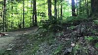
Fun trail with many small jumps and a big wooden table top that used to be Bromonts Iconic 30ft river gap.

Access Info

Access through the Banana Split #51, at the crossroads go left onto La Veuse (Bas) #57 until you get to the next crossroads and Bromance #52 is on the right of where La Veuse (Bas) #57 goes back into the trees at the top of the fire road

Adaptive Bike Info
aMTB Black Rating: Advanced obstacles exist, some trail obstructions.

You may or may not be able to ride this solo without a support rider, depending on the type of adaptive bike being ridden and the riders skill. But I would personally rate it an aMTB 3 (Black).

Bike Park

Traditionally Indigenous Territory
More Stats for Bromance mountain bike trail trail
  • Altitude change
    -343 ft
  • Altitude min
    845 ft
  • Altitude max
    1,188 ft
  • Altitude start
    1,188 ft
  • Altitude end
    846 ft
  • Grade
    -13.1%
  • Grade max
    -37%
  • Grade min
    -3.3%
  • Distance down
    2,621 ft
  • Avg time
    00:02:33
  • Avg reverse time
    00:06:16
  • view trail stats
Status:
on Nov 7, 2024
Avg: 4.04 (18 votes)
Your vote: 0

view (6,235)
close
3D
Trail Conditions
  • Unknown
  • Snow Groomed
  • Snow Packed
  • Snow Covered
  • Snow Cover Partial
  • Freeze/thaw Cycle
  • Icy
  • Prevalent Mud
  • Wet
  • Variable
  • Ideal
  • Dry
  • Very Dry
Trail Flow (Ridden Direction)
Trailforks scans users ridelogs to determine the most popular direction each trail is ridden. A good flowing trail network will have most trails flowing in a single direction according to their intension.
The colour categories are based on what percentage of riders are riding a trail in its intended direction.
  • > 96%
  • > 90%
  • > 80%
  • > 70%
  • > 50%
  • < 50%
  • bi-directional trail
  • no data
Trail Last Ridden
Trailforks scans ridelogs to determine the last time a trail was ridden.
  • < 2 days
  • < 1 week
  • < 2 weeks
  • < 1 month
  • < 6 months
  • > 6 months
Trail Ridden Direction
The intended direction a trail should be ridden.
  • Downhill Only
  • Downhill Primary
  • Both Directions
  • Uphill Primary
  • Uphill Only
  • One Direction
Contribute Details
Colors indicate trail is missing specified detail.
  • Description
  • Photos
  • Description & Photos
  • Videos
Trail Popularity ?
Trailforks scans ridelogs to determine which trails are ridden the most in the last 9 months. Trails are compared with nearby trails in the same city region with a possible 25 colour shades. Think of this as a heatmap, more rides = more kinetic energy = warmer colors.
  • most popular
  • popular
  • less popular
  • not popular
ATV/ORV/OHV Filter
Max Vehicle Width
inches
US Cell Coverage
Legend
cell carrier legend

Radar Time
x Activity Recordings
Trailforks users anonymized public ridelogs from the past 6 months.
  • mountain biking recent
  • mountain biking (>6 month)
  • hiking (1 year)
  • moto (1 year)
Activity Recordings
Trailforks users anonymized public skilogs from the past 12 months.
  • Downhill Ski
  • Backcountry Ski
  • Nordic Ski
  • Snowmobile
Winter Trails
Warning A routing network for winter maps does not exist. Selecting trails using the winter trails layer has been disabled.
x Missing Trails
Most Popular
Least Popular
Trails are colored based on popularity. The more popular a trail is, the more red. Less popular trails trend towards green.
Jump Magnitude Heatmap
Heatmap of where riders jump on trails. Zoom in to see individual jumps, click circles to view jump details.
Trails Deemphasized
Trails are shown in grey.
disable
Only show trails with NO bikes.
enable

Save the current map location and zoom level as your default home location whenever this page is loaded.

Save
      Directions to bromance trailhead (45.288290, -72.630560)
      update trails status or condition

      Bromance Trail Reports

      Recent Ridelog Activity on Trail

      Past Week
      • 0 rides
      •  
      6 Months
      • 1 rides
      • 20 miles avg distance
      All
      • 472 rides
      • Last: Sep 8, 2024

      Photos

      more »
      71 |
      Aug 28, 2021 @ 9:50am
      Aug 28, 2021
      72 |
      Aug 28, 2021 @ 9:50am
      Aug 28, 2021
      81 |
      Aug 28, 2021 @ 9:51am
      Aug 28, 2021
      475 |
      Nov 4, 2019 @ 5:15am
      Nov 4, 2019

      Trail Lists

      Routes with this trail

      titledistance
      Bromont mini enduro alternate10 miles

      1 Review & Comments


      We hope you've been enjoying Trailforks!

      Create a FREE account to view trail comments and much more.

      Videos

      more »
      52 - ZIGZAG | BROMONT | JUNE 2021
      0:36 | 341 | Jul 23, 2021 , Bromont
      youtuber BROMONT DOWNHILL CRASH Trail #52
      0:05 | 423 | Jul 16, 2018 , Bromont
      A stupid crash
      155 | May 15, 2022 , Bromont
      52 - ZIGZAG | BROMONT | JUNE 2021
      111 | Jul 24, 2021 , Bromont
      • By Mavrey & contributors
      • #7279 - 3,831 views

      You must enter a description before submitting.