

more stats
8.3 miles
Distance
1,453 ft
Climb
-1,403 ft
Descent
01:46:59
Avg time
50 ft
Altitude change
1,330 ft
Altitude min
1,934 ft
Altitude max
1,624 ft
Altitude start
1,673 ft
Altitude end
0.1%
Grade
-38%
Grade max
38.3%
Grade min
4 miles
Distance climb
4 miles
Distance down
5,020 ft
Distance flat
01:46:59
Avg time

Rogers Camp Loop Details

  • Activities
    • Mountain Bike
    • Hike
    • Trail Running
  • Riding Area
    Tillamook State Forest
    Tillamook, Oregon
  • Difficulty Rating
  • Local Popularity
    95 in Mountain Biking [+]
    • 95 in Trail Running
    • 65 in Hiking
  • Global Ranking
    #19537 in Mountain Biking [+]
    • #259 in Trail Running
    • #1886 in Hiking
  • Trail Type
    Singletrack
  • Bike Type
    AM, XC
  • Direction
    Both Directions
  • Climb Difficulty
    Blue
  • Physical Rating
    Moderate
  • Season
    Mainly late spring (April) to fall (early November), but can be ridden year round.
  • Dogs Allowed
    Yes
  • eBike Allowed
  • Land Owner
    Oregon Department of Forestry

This is an awesome cross country trail, with lots of roots and rocks and some faster downhill sections, along with a few steeper climbs. Punchy climbs await the most skilled.

It can be ridden in both directions, but most riders prefer a clockwise direction (if riding clockwise, there's a short climb out on a dirt road at the end that's no fun riding down). The loop follows the Wilson Wagon Trail (a historic trail) and the Gravelle Brothers Trail to make the loop.

Parts of the trail are a bit overgrown with vegetation, and its muddy after lots of rain and riders, but the drainage is much improved from what it was before 2010 (or so).

It's not a long nor tough ride, but for a longer ride this can be combined with a loop around Gale's Creek - the combined ride can be done as a figure 8, and thus avoids the dirt road that's part of the loop here. Adding the Storey Creek trail is another option.

Access Info

Access the trail head via by driving past Banks, Oregon on HWY6 heading west. Follow the signs to Brown's Camp. Once you turn off the highway and drive up, take the first left 80 yards from the highway and drive 150 yards to the kiosk on your right, trailhead is right behind the restroom/kiosk area. Very stealthy.

Traditionally Indigenous Territory

Recent Activity on Trail

Past Week
  • 1 rides
  • 9 miles average
6 Months
  • 45 rides
  • 9 miles avg distance
All
  • 331 rides
  • Last: Sep 20, 2026
c1c2c3c4
January
February
March
April
May
June
July
August
September
October
November
December
update trails status or condition

Rogers Camp Loop Trail Reports

statusdatedescription
Sep 20, 2026 @ 10:03pm (America/Los_Angeles)
Sep 20, 2026
One tree down between Beaver Dam Road and Wilson River. Log bridge over Wilson River at the end (going CW) has been removed. OK crossing...
Aug 23, 2026 @ 5:07pm (America/Los_Angeles)
Aug 23, 2026
Cleared this very annoying pair a few days ago. ( I was riding storey burn loop and included an out-and-back down rogers to get these). a few...
Jul 25, 2026 @ 3:26pm (America/Los_Angeles)
Jul 25, 2026
Riding well, but pretty overgrown in spots from roughly 6:00 to 10:00 on the loop. Also there was a stranded 4 wheeler on the singletrack at...
Jul 21, 2026 @ 5:25pm (America/Vancouver)
Jul 21, 2026
3 sets of downed trees. Prior is still there and two more joined the party. One is maybe 4" slightly uphill from Storey Burn.
Jul 5, 2026 @ 9:43am (America/Vancouver)
Jul 5, 2026
more »
Status:
on Sep 20, 2026
Dry
Avg: 4 (23 votes)
Your vote: 0

view (1,737)
close
      Directions to rogers-camp-loop trailhead (45.622750, -123.375430)

      Photos

      48 more »
      report
      mtb
      212 |
      Apr 10, 2024 @ 2:57pm
      Apr 10, 2024
      mtb
      444 |
      Apr 17, 2021 @ 8:56am
      Apr 17, 2021
      mtb
      365 |
      Apr 17, 2021 @ 8:56am
      Apr 17, 2021
      mtb
      491 |
      Nov 2, 2019 @ 6:22pm
      Nov 2, 2019

      Videos

      2 more »
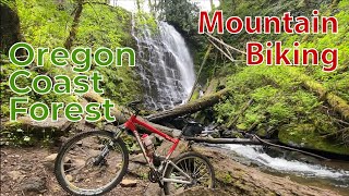
      Oregon Coast Mountain bike trail - Nels Rogers...
      mtb
      17:18 | 378 | Jul 5, 2024 , Tillamook
      DH Root Section on Browns Camp Loop Trail
      mtb
      0:12 | | Apr 12, 2020 , Tillamook

      Routes with this trail

      15 miles • 2,578 ft • 3 • Loop •
      Gales Creek trail, Rogers Camp trail, Storey Burn trail, Gales Creek back to Gales Creek Camp Ground.
      14 miles • 2,644 ft • 3 •
      Route can be started from Summit Trailhead or from Rogers Rd (entrance to Gales Creek Campground) Can be...
      ★ 4.0 • 28 miles • 5,623 ft • 12 •
      Linking all of the Gales Creek area trails together provides a legendary experience. Leave from Reeher's Camp.
      4.0 ★★★★★
      23 Ratings
      5 ★ 30%
      4 ★ 43%
      3 ★ 22%
      2 ★ 4%
      1 ★

      13 Reviews & Comments

      kWfDiU
      Trail is in great shape! A little muddy in the usual spots and a little frozen in spots but overall clear except for one log across near the restrooms/parking lot.
      ddocky
      New Gravelle Brothers trail at the end (of clockwise loop). The old stretch behind the ODOT lot has been decommissioned.
      ddocky
      Anyone notice the new trail being built? Going clockwise, It's on the uphill after the Storey Burn intersection, just where the single track tops out onto the old road to the gravel pit. No idea where the other end will be.

      We hope you've been enjoying Trailforks!

      Create a FREE account to view all trail reviews and much more.

      • By Qdavison & contributors
      • #42693 - 18,902 views

      Frequently Asked Questions

      ▼ Where is Rogers Camp Loop located?
      Rogers Camp Loop is located in Tillamook State Forest, Tillamook, Oregon, United States. It is part of the Tillamook State Forest trail network. The trailhead is located at coordinates 45.62275, -123.37543.
      ▼ How hard is Rogers Camp Loop?
      Rogers Camp Loop is rated as Blue difficulty. The physical rating is Moderate. The average grade is 0.1%. The climb difficulty is rated Blue.
      ▼ What is the elevation gain for Rogers Camp Loop?
      Rogers Camp Loop has 1,453 ft of elevation gain. The trail has 1,403 ft of elevation descent. The elevation ranges from 1,330 ft to 1,934 ft.
      ▼ Is Rogers Camp Loop a point to point trail?
      Rogers Camp Loop is not a point to point trail. The direction is Both Directions. The trail type is singletrack.
      ▼ How long is Rogers Camp Loop?
      Rogers Camp Loop is 8.3 miles long. The trail type is singletrack.
      ▼ Are dogs allowed on Rogers Camp Loop?
      Yes, dogs are allowed on Rogers Camp Loop. Please keep dogs on a leash where required and clean up after them.
      ▼ When is the best time of year to ride Rogers Camp Loop?
      Based on activity log data, the most popular months to ride Rogers Camp Loop are:
      • June (26 activities)
      • July (24 activities)
      • May (23 activities)
      Check the reports page for current trail conditions.
      ▼ How do I access Rogers Camp Loop? Where is the closest parking trailhead?
      The closest parking and trailhead locations to Rogers Camp Loop are: View all parking locations in the area.
      ▼ How long does it take to ride Rogers Camp Loop?
      Based on recorded activities, it takes an average of 1 hour 51 minutes to ride Rogers Camp Loop. The trail is 8.3 miles long. Actual times will vary based on fitness level, conditions, and pace. View recent activity logs for more details.
      ▼ How busy is Rogers Camp Loop?
      Rogers Camp Loop is a very popular trail. There have been 1,308 recorded activities on this trail. The trail has received 1,737 check-ins. View recent activity on this trail.

      Hit the Trail

      Open in App

      Get this trail on your phone instantly.

      open trail in app

      Download Trail

      Save to wishlist, Garmin & download.
      save the trail

      Find Related Routes

      Find routes and users activities that include this trail.
      find routes for this trail

      You must enter a description before submitting.



