more stats
2,005 ft
Distance
-259 ft
Descent
00:01:32
Avg time
-259 ft
Altitude change
637 ft
Altitude min
896 ft
Altitude max
896 ft
Altitude start
636 ft
Altitude end
-12.9%
Grade
-39.5%
Grade max
-3.1%
Grade min
2,005 ft
Distance down
00:01:32
Avg time

Cactus Details

  • Activities
    • Mountain Bike
    • Horse
    • Hike
    • Trail Running
  • Riding Area
    Santiago Oaks
    Orange, California
  • Difficulty Rating
  • Voted Difficulty
    Blue (3 votes)
  • Local Popularity
    100 in Mountain Biking [+]
    • 65 in Trail Running
    • 80 in Hiking
    • 5 in Horseback
  • Global Ranking
    #37334 in Mountain Biking [+]
    • #72084 in Trail Running
    • #61829 in Hiking
    • #1141 in Horseback
  • Trail Type
    Singletrack
  • Bike Type
    DH, AM, XC
  • Climb Difficulty
    Black Diamond
  • Physical Rating
    Moderate
  • Trail Visibility
    Always easy to follow
  • Season
    makes it nice and tacky during rain
  • Dogs Allowed
    Yes
  • eBike Allowed
  • TTFs on Trail
    Berm, Jump
  • Ride in Rain
    Yes

Starting June 1, 2021 this Trail is DH for all user groups as part of the OC Parks Trails Pilot Project

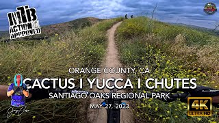
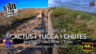
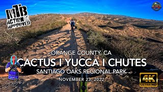
Short, flow trail that starts off of Barham Ridge. It is a relatively fast rolling trail with multiple berms. During the summer/dry it can be relatively loose. It is usually very good/fast after some moisture. It is typically ridden downhill from Barham Ridge to the small Valley in between Barharm Ridge and the 3 B's climb directly across. You can continue across to climb Bumblebee (which climbs to the middle of the B's), turn right to go up Coachwhip and back to Barham Ridge or left for a small connector to Mountain Goat. It is popular with bikes, however, can be busy with hikers, especially during cooler/busier days.

Access Info

Accessed from the top of Barham Ridge. The most popular way is to climb up Chutes Trail (New Chutes). There are two Chutes trail that follow roughly the same lines, however stay left to climb Chutes Trail. Old Chutes is downhill only. Take Roadrunner to the end, there is a info sign and a small, half-buried log ride. Head past the sign, cross the dry river bed area and stay to the lift to climb Chutes Trail.

Local Trail Association
Traditionally Indigenous Territory

Recent Activity on Trail

Past Week
  • 14 rides
  • 11 miles average
6 Months
  • 243 rides
  • 12 miles avg distance
All
  • 2,265 rides
  • Last: Jun 13, 2026
c1c2c3c4
January
February
March
April
May
June
July
August
September
October
November
December
update trails status or condition

Cactus Trail Reports

statusdatedescription
Apr 19, 2026 @ 11:07pm (America/Los_Angeles)
Apr 19, 2026
Rode on 4/17/26 slight overgrowth but not too bad
Feb 28, 2026 @ 6:42pm (America/Los_Angeles)
Feb 28, 2026
A good bit of ruts and breaking bumps, could use some work, not ideal rn
Oct 12, 2025 @ 8:09am (America/Los_Angeles)
Oct 12, 2025
Sep 7, 2025 @ 8:16am
Sep 7, 2025
Jun 15, 2025 @ 8:18am
Jun 15, 2025
Mustard has been mostly cleared.
more »
Status:
on Apr 19, 2026
Avg: 4.11 (20 votes)
Your vote: 0

view (24,551)
close
3D
Trail Conditions
  • Unknown
  • Snow Groomed
  • Snow Packed
  • Snow Covered
  • Snow Cover Partial
  • Freeze/thaw Cycle
  • Icy
  • Prevalent Mud
  • Wet
  • Variable
  • Ideal
  • Dry
  • Very Dry
Trail Flow (Ridden Direction)
Trailforks scans users ridelogs to determine the most popular direction each trail is ridden. A good flowing trail network will have most trails flowing in a single direction according to their intension.
The colour categories are based on what percentage of riders are riding a trail in its intended direction.
  • > 96%
  • > 90%
  • > 80%
  • > 70%
  • > 50%
  • < 50%
  • bi-directional trail
  • no data
Trail Last Ridden
Trailforks scans ridelogs to determine the last time a trail was ridden.
  • < 2 days
  • < 1 week
  • < 2 weeks
  • < 1 month
  • < 6 months
  • > 6 months
Trail Ridden Direction
The intended direction a trail should be ridden.
  • Downhill Only
  • Downhill Primary
  • Both Directions
  • Uphill Primary
  • Uphill Only
  • One Direction
Contribute Details
Colors indicate trail is missing specified detail.
  • Description
  • Photos
  • Description & Photos
  • Videos
Trail Popularity ?
Trailforks scans ridelogs to determine which trails are ridden the most in the last 9 months. Trails are compared with nearby trails in the same city region with a possible 25 colour shades. Think of this as a heatmap, more rides = more kinetic energy = warmer colors.
  • most popular
  • popular
  • less popular
  • not popular
ATV/ORV/OHV Filter
Max Vehicle Width
inches
US Cell Coverage
Legend
cell carrier legend

Radar Time
Activity Recordings
Trailforks uses anonymized public activity data. ?
Activity Recordings
Trailforks uses anonymized public activity data. ?
Personal Heatmap
Activity Types
all / none
Options
2
Date range month
Winter Trails
Warning A routing network for winter maps does not exist. Selecting trails using the winter trails layer has been disabled.
Missing Trails
Most Popular
Least Popular
Trails are colored based on popularity. The more popular a trail is, the more red. Less popular trails trend towards green.
Jump Magnitude Heatmap
Heatmap of where riders jump on trails. Zoom in to see individual jumps, click circles to view jump details.
BC Backroad Status

Service Road Atlas is a free to use, community-driven service for viewing and creating reports on the numerous back-country service roads around B.C. and Alberta.

map legend
Slope Aspect
Direction the slope faces
Flat N NE E SE S SW W NW
Trails Deemphasized
Trails are shown in grey.
disable
Only show trails with no bike usage.
Enable
Suggested Layers
Based on selected activity type

    Save the current map location and zoom level as your default home location whenever this page is loaded.

    Save
        Directions to cactus trailhead (33.818310, -117.758280)

        Photos

        15 more »
        109 |
        Aug 29, 2019 @ 9:56am
        Aug 29, 2019
        296 |
        Feb 7, 2017 @ 8:31pm
        Feb 7, 2017
        465 |
        Feb 7, 2017 @ 8:32pm
        Feb 7, 2017
        542 |
        Jun 6, 2016 @ 12:02pm
        Jun 6, 2016

        Videos

        39 more »
        youtuber Santiago Oaks Mountain Biking Trail Guide -...
        14:44 | 247 | Mar 28, 2021 , Orange
        youtuber MTB Riding The Oaks, May 27, 2023 #trending #viral
        14:51 | 141 | May 28, 2023 , Orange
        youtuber MTB Riding The Oaks Now and Then | A Trail...
        14:38 | 281 | May 30, 2023 , Orange
        youtuber MTB Riding The Oaks, November 23, 2022...
        14:38 | 127 | May 27, 2023 , Orange

        Routes with this trail

        5.0 8 miles 1,232 ft 35 Loop
        Santiago Oaks is a well-known trail network located in Orange County. The park has multiple options for...
        4.0 10 miles 1,817 ft 36 Loop
        Santiago Oaks is a well-known trail network located in Orange County. The park has multiple options for...
        4.0 5 miles 1,051 ft 25 Loop
        Santiago Oaks is a well-known trail network located in Orange County. The park has multiple options for...

        3 Reviews & Comments


        We hope you've been enjoying Trailforks!

        Create a FREE account to view trail comments and much more.

        • By zdrenduro67 & contributors
        • #7498 - 5,831 views

        Frequently Asked Questions About Cactus

        Where is Cactus located?
        Cactus is located in Santiago Oaks, Orange, California, United States. It is part of the Santiago Oaks trail network. The trailhead is located at coordinates 33.81831, -117.75828.
        How hard is Cactus?
        Cactus is rated as Blue difficulty. The physical rating is Moderate. The average grade is 12.9%. The climb difficulty is rated Black Diamond.
        What is the elevation gain for Cactus?
        The trail has 259 ft of elevation descent. The elevation ranges from 637 ft to 896 ft.
        How long is Cactus?
        Cactus is 2,005 ft long. The trail type is singletrack.

        Hit the Trail

        Open in App

        Get this trail on your phone instantly.
        open trail in app

        Download Trail

        Save to wishlist, Garmin & download.
        save the trail

        Find Related Routes

        Find routes and users activities that include this trail.
        find routes for this trail

        You must enter a description before submitting.