315 ft
Distance
-18 ft
Descent
00:01:58
Avg time

Cambria Details

  • Activities
    • Mountain Bike
    • Hike
    • Trail Running
    • Snowshoe
  • Riding Area
    Jefferson Forest
    Richmond Hill, Ontario
  • Difficulty Rating
  • Voted Difficulty
    Black Diamond (1 vote)
  • Trail Type
    Singletrack
  • Bike Type
    DH, AM, Fat
  • Direction
    Downhill Only
  • Climb Difficulty
    Double Black Diamond
  • Physical Rating
    Moderate
  • Trail Visibility
    Always easy to follow
  • Dogs Allowed
    Yes
  • eBike Allowed
  • TTFs on Trail
    Berm, Gap Jump, Log Ride
  • Global Ranking
    #14491 in Mountain Biking [+]
    • #46071 in Hiking
    • #1846 in Snowshoeing
  • Local Popularity
    50 in Mountain Biking [+]
    • 5 in Trail Running
    • 70 in Hiking
    • 5 in Snowshoeing
  • Land Owner
    Toronto Region Conservation Authority

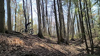
A technical downhill trail with roots, some rocks, steep switchbacks with berms. Connects to Sleeveless Trail or alternately can join into bottom half of Nugget trail that includes a small drop gap. Downhill only trail, please don't try riding up it

This trail is unsanctioned.

More Stats for Cambria mountain bike trail trail
  • Altitude change
    -18 ft
  • Altitude min
    980 ft
  • Altitude max
    998 ft
  • Altitude start
    998 ft
  • Altitude end
    981 ft
  • Grade
    -5.7%
  • Grade max
    -10.4%
  • Grade min
    -2.7%
  • Distance down
    240 ft
  • Distance flat
    75 ft
  • Avg time
    00:01:58
  • Avg reverse time
    00:01:40
  • view trail stats
Status:
on Aug 18, 2023
Ideal
Avg: 4.5 (2 votes)
Your vote: 0

view (1,336)
close
3D
Trail Conditions
  • Unknown
  • Snow Groomed
  • Snow Packed
  • Snow Covered
  • Snow Cover Inadequate
  • Freeze/thaw Cycle
  • Icy
  • Prevalent Mud
  • Wet
  • Variable
  • Ideal
  • Dry
  • Very Dry
Trail Flow (Ridden Direction)
Trailforks scans users ridelogs to determine the most popular direction each trail is ridden. A good flowing trail network will have most trails flowing in a single direction according to their intension.
The colour categories are based on what percentage of riders are riding a trail in its intended direction.
  • > 96%
  • > 90%
  • > 80%
  • > 70%
  • > 50%
  • < 50%
  • bi-directional trail
  • no data
Trail Last Ridden
Trailforks scans ridelogs to determine the last time a trail was ridden.
  • < 2 days
  • < 1 week
  • < 2 weeks
  • < 1 month
  • < 6 months
  • > 6 months
Trail Ridden Direction
The intended direction a trail should be ridden.
  • Downhill Only
  • Downhill Primary
  • Both Directions
  • Uphill Primary
  • Uphill Only
  • One Direction
Contribute Details
Colors indicate trail is missing specified detail.
  • Description
  • Photos
  • Description & Photos
  • Videos
Trail Popularity ?
Trailforks scans ridelogs to determine which trails are ridden the most in the last 9 months. Trails are compared with nearby trails in the same city region with a possible 25 colour shades. Think of this as a heatmap, more rides = more kinetic energy = warmer colors.
  • most popular
  • popular
  • less popular
  • not popular
ATV/ORV/OHV Filter
Max Vehicle Width
inches

Radar Time
x Activity Recordings
Trailforks users anonymized public ridelogs from the past 6 months.
  • mountain biking recent
  • mountain biking (>6 month)
  • hiking (1 year)
  • moto (1 year)
Activity Recordings
Trailforks users anonymized public skilogs from the past 12 months.
  • Downhill Ski
  • Backcountry Ski
  • Nordic Ski
  • Snowmobile
Winter Trails
Warning A routing network for winter maps does not exist. Selecting trails using the winter trails layer has been disabled.
x Missing Trails
Most Popular
Least Popular
Trails are colored based on popularity. The more popular a trail is, the more red. Less popular trails trend towards green.
Jump Magnitude Heatmap
Heatmap of where riders jump on trails. Zoom in to see individual jumps, click circles to view jump details.
Trails Deemphasized
Trails are shown in grey.
disable
Only show trails with NO bikes.
enable

Save the current map location and zoom level as your default home location whenever this page is loaded.

Save
      Directions to cambria trailhead (43.934870, -79.424720)
      update trails status or condition

      Cambria Trail Reports

      statusdatedescription
      Aug 18, 2023 @ 6:00am
      Aug 18, 2023
      All north ridge trails running great. Thanks to all the fairies that fixed them up.
      Apr 24, 2023 @ 7:34pm
      Apr 24, 2023
      Trail has been re-opened, all tree's cleared and trail has been raked along with bottom part of Nugget that can be accessed via Cambria trail....
      Jul 17, 2020 @ 12:09am
      Jul 17, 2020
      Lower portion of the trail is in disrepair. Logs/branches obstruct the path and it is unrideable.
      Apr 28, 2020 @ 11:40am
      Apr 28, 2020
      Jan 14, 2020 @ 3:42pm
      Jan 14, 2020
      view all reports »

      Recent Ridelog Activity on Trail

      Past Week
      • 2 rides
      • 8 miles avg distance
      6 Months
      • 35 rides
      • 11 miles avg distance
      All
      • 1,301 rides
      • Last: Sep 24, 2023

      Photos

      more »
      313 |
      May 28, 2017 @ 6:08am
      May 28, 2017
      343 |
      May 28, 2017 @ 6:08am
      May 28, 2017
      333 |
      May 28, 2017 @ 6:07am
      May 28, 2017
      282 |
      May 28, 2017 @ 6:07am
      May 28, 2017

      1 Review & Comments


      We hope you've been enjoying Trailforks!

      Create a FREE account to view trail comments and much more.

      Videos

      more »
      youtuber GTA Mountain Bike Trails - Jefferson Forest in...
      841 | Jul 27, 2017 , Richmond Hill
      Cambria
      71 | Apr 28, 2023 , Richmond Hill
      • #45023 - 2,359 views
      • subscribe
      • flag
      • login to download gpx or kml files.