
more stats
1.9 miles
Distance
388 ft
Climb
-398 ft
Descent
00:19:46
Avg time
-10 ft
Altitude change
27 ft
Altitude min
345 ft
Altitude max
37 ft
Altitude start
27 ft
Altitude end
-48.905%
Grade max
37.657%
Grade min
4,633 ft
Distance climb
3,417 ft
Distance down
1,899 ft
Distance flat
00:19:46
Avg time

Cameron Ridge Details

  • Activities
    • Mountain Bike
    • Hike
    • Trail Running
  • Riding Area
  • Difficulty Rating
  • Local Popularity
    55 in Mountain Biking heatmap [+]
    • 5 in Trail Running
    • 5 in Hiking
  • Global Ranking
    #108912 in Mountain Biking [+]
    • #335687 in Trail Running
    • #345556 in Hiking
  • National Ranking
    #2,476 in Mountain Biking · New Zealand [+]
    • #3,973 in Trail Running
    • #3,750 in Hiking
  • Trail Type
    Singletrack
  • Bike Type
    XC
  • Direction
    Both Directions
    Popular Direction Shown
  • Climb Difficulty
    Blue
  • Physical Rating
    Moderate
  • Dogs Allowed
    Yes

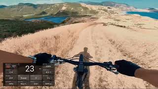
Traverses the ridge between Lake Kohangapiripiri and Lake Kohangatera.

A grassy track that climbs through farmland to the ridge between Lake Kohangapiripiri and Lake Kohangatera. With great views of the lakes, and beyond, this is a very picturesque area.

This track can be ridden either as a diversion from Baring Head, or as part of a loop around Lake Kohangapiripiri (the Lake Kohangatera loop track no longer exists due to the permanent removal of the Gollans Stream boardwalk). At a clearly sign posted major intersection, head north along Kohangapiripiri or drop down to the right for Kohangatera Lookout, which is now a dead end.

Access Info

This track can be ridden in either direction, though it is easiest to go along Baring Head past Lake Kohangapiripiri to immediately before the Lake Kohangatera outlet, where the track is initially a 4x4 road that goes up the hill. Follow that road, which soon becomes grassy, to the ridge.

At a sign posted intersection, turn left to go up a bit and then down a very steep descent to the eastern shore of Lake Kohangapiripiri and then back to Baring Head 1.1 km from where you started.

Tags
BoardwalkLakeRidgelineViews

Recent Activity on Trail

Past Week
  • 0 rides
  •  
6 Months
  • 0 rides
  •  
All
  • 13 rides
  • Last: Apr 11, 2026
c1c2c3c4
January
February
March
April
May
June
July
August
September
October
November
December
update trails status or condition

Cameron Ridge Trail Reports

Status:
on Oct 25, 2019
Dry
Avg: 3.84 (1 votes)
Your vote: 0

view (129)
close
      Directions to cameron-ridge trailhead (-41.374286, 174.863660)

      Photos

      5 more »
      mtb
      66 |
      Apr 30, 2025 @ 8:22pm
      Apr 30, 2025
      mtb
      574 |
      Feb 29, 2004 @ 7:43pm
      Feb 29, 2004
      mtb
      110 |
      Nov 23, 2018 @ 6:21pm
      Nov 23, 2018
      mtb
      136 |
      Nov 23, 2018 @ 6:21pm
      Nov 23, 2018

      Videos

      1 more »
      Cameron Ridge
      ebike
      10:16 | 289 | Feb 25, 2024 , My City
      3.0 ★★★★★
      1 Ratings
      5 ★
      4 ★
      3 ★ 100%
      2 ★
      1 ★

      2 Reviews & Comments

      rjhinde
      One of my favourite trails, if riding an analog bike ride in the northerly direction, if on ebike the opposite is better as you get spectacular views as you ride downhill and look out over Fitzroy Bay toward Baring Head.
      chickenlittleNZ chickenlittleNZ
      Nice track can be ridden in the rain, but as the descriptions says best to ride in a northerly direction, first is a 4x4 track which is a bit uneven but do-able, then it goes to a mainly grass covered track which seems to be regularly mowed...! so traction is good the last bit of the track back down to the other lake reserve is steepish which is the reason for decending here rather than ascending.... there are sheep around so plenty of fresh landmines to dodge....Still lovely scenery and not a technical track. I did it on touring/hybrid tyres and was fine, just dropped the pressure for excellent grip on the cut grass...would be an OK multi weather track.

      We hope you've been enjoying Trailforks!

      Create a FREE account to view all trail reviews and much more.

      • By YogiNZ & contributors
      • #32845 - 3,435 views

      Frequently Asked Questions

      ▼ Where is Cameron Ridge located?
      Cameron Ridge is located in Pencarrow Head, New Zealand. It is part of the Pencarrow Head trail network. The trailhead is located at coordinates -41.37429, 174.86366.
      ▼ How hard is Cameron Ridge?
      Cameron Ridge is rated as Blue difficulty. The physical rating is Moderate. The climb difficulty is rated Blue.
      ▼ What is the elevation gain for Cameron Ridge?
      Cameron Ridge has 388 ft of elevation gain. The trail has 398 ft of elevation descent. The elevation ranges from 27 ft to 345 ft.
      ▼ Is Cameron Ridge a point to point trail?
      Cameron Ridge is not a point to point trail. The direction is Both Directions. The trail type is singletrack.
      ▼ How long is Cameron Ridge?
      Cameron Ridge is 1.9 miles long. The trail type is singletrack.
      ▼ Are dogs allowed on Cameron Ridge?
      Yes, dogs are allowed on Cameron Ridge. Please keep dogs on a leash where required and clean up after them.
      ▼ How do I access Cameron Ridge? Where is the closest parking trailhead?
      The closest parking and trailhead locations to Cameron Ridge are: View all parking locations in the area.
      ▼ How long does it take to ride Cameron Ridge?
      Based on recorded activities, it takes an average of 20 minutes to ride Cameron Ridge. The trail is 1.9 miles long. Actual times will vary based on fitness level, conditions, and pace. View recent activity logs for more details.
      ▼ How busy is Cameron Ridge?
      Cameron Ridge is a moderately popular trail. There have been 134 recorded activities on this trail. The trail has received 129 check-ins. View recent activity on this trail.

      Hit the Trail

      Open in App

      Get this trail on your phone instantly.

      open trail in app

      Download Trail

      Save to wishlist, Garmin & download.
      save the trail

      Find Related Routes

      Find routes and users activities that include this trail.
      find routes for this trail

      You must enter a description before submitting.

